Skip to Content
Report an accessibility problem

Request for student proposals on conserving desert mountain parks

July 28, 2014

The goal of the Central Arizona Conservation Alliance Student Research Grants program is to support research that assists land managers in making informed decisions about natural and cultural resources of the City of Phoenix Desert Mountain Parks and Preserves, Maricopa County Regional Parks, and City of Scottsdale’s McDowell Sonoran Preserve.  To that end, we encourage applied and/or usable basic research that 1) fills gaps in the ecological, social, and cultural understanding of Preserve resources, and 2) addresses specific management issues.  Preference will be given to projects addressing human impact, developing indicators and standards for resource protection, local and regional benefits derived by preserve/open space park systems, assessing wildlife corridors/connectivity/linkages, climate change and/or urban heat island effects, and species inventories. Grants will be for up to $2,500 for individual research proposals or for up to $5,000 to support collaborative research projects.

For 2014 grants, the deadline for application is 9/2/2014. Awards will be announced by 9/15/2014.

Background

The Central Arizona Conservation Alliance (CAZCA) is a collaboration of land managers, scientists, educators, community members, and conservation-based non-profit organizations committed to focusing collective expertise on the ecological and recreational sustainability of the mountain parks/preserves in and around the Valley. The Alliance believes that community engagement in the study, restoration, and promotion of these preserves will be critical to its success.

Partners in the CAZCA are: Desert Botanical Garden (as coordinating institution); Maricopa County Parks and Recreation Department; City of Phoenix Parks and Recreation Department- Natural Resources Division; McDowell Sonoran Conservancy; Audubon Arizona; Phoenix Mountains Preservation Council; and Arizona State University’s Central Arizona Long-term Ecological research project (CAP LTER), School of Life Sciences, School of Community Resources and Development, and Center for Biodiversity Outcomes. The partnership’s focal preserves are City of Phoenix Desert Mountain Parks and Preserves, Maricopa County Regional Parks, and City of Scottsdale’s McDowell Sonoran Preserve.

The goal of the Student Research Grants program is to support research that assists land managers in making informed decisions about the natural and cultural resources of the Preserves. To that end, we encourage applied and/or usable basic scientific and scholarly research that 1) fills gaps in the ecological, social, and cultural understanding of Preserve resources, and 2) addresses specific management issues.  Grants will be for up to $2,500 for individual research proposals or for up to $5,000 to support collaborative research projects.

Eligibility

Grant recipients must be self-directed individuals whose work will contribute to the scientific knowledge of the natural and cultural resource of our local desert mountain preserves. CAZCA’s Research Grants support research in the biological, physical, social, and cultural sciences. We welcome proposals from across the study areas listed above, but 2014 priority will be given to research with opportunities for community engagement and which focus toward

  • human impact
  • developing indicators and standards for resource protection
  • local and regional benefits derived by preserve/open space park systems
  • wildlife corridors/connectivity/linkages
  • climate change and/or urban heat island effects
  • species inventories

CAZCA Grants are designed to support funding for graduate students, but may also be appropriate for undergraduate students. Researchers must have study sites on one or more of these preserves. Collaborative projects across two or more preserves/parks is encouraged.

Recipients must complete their work within one year of receiving grant funds, have some public outreach component to their work, and provide a final report and presentation to the partnership.

Allowable expenses

Funds may be used for a variety of purposes including but not limited to materials/supplies, local travel directly related to field work, and lab fees. Requests for permanent equipment are not encouraged, but will be considered. Any permanent equipment purchased with grant funds remains the property of the Central Arizona Conservation Alliance and will need to be returned at the end of the project. Funds may not be used for tuition, student fees, institutional overhead, course textbooks/materials, thesis preparation, publication of results, costs associated with attendance to professional meetings, or fringe benefits.

Provisional acceptance pending research permit

Grant funding is provisional until a research and collecting permit is approved and issued for each study site. Being awarded a grant is NOT A GUARANTEE that a research and collecting permit will be issued for work in a park/preserve as written in the proposal. Modification of methods or sites may be necessary. Grant recipients are encouraged to submit the application for a research and collecting permit for work in a park/preserve as soon as possible. Prior to issuing a permit, land management staff will review the project for compliance with policies and administrative concerns.

Requirements of award winners

Fulfill all conditions of the park/preserve research permit.

Awardees are required to provide the following to the Central Arizona Conservation Alliance Program Coordinator (Stacie Beute) within three months after the completion of field work.

  1. At least one public outreach product such as public participation in the research itself, a talk at a nature center, or a poster, fact sheet, classroom activity to share the research process and results. If a talk is given, please share plans for study, observations to date, and similar projects already completed. Please discuss tentative choice for public outreach with CAZCA’s program coordinator Stacie Beute.
  2. Provide electronic final report to include: intro, methods, results, discussion, relevance to management, literature cited, and acknowledgements or thesis/dissertation as appropriate.
  3. Send several digital photos of researcher/field work in progress with captions for photos in a separate word document

Application instructions

Applicants must submit the following documents via email to Central Arizona Conservation Alliance Program Coordinator Stacie Beute (sbeute@dbg.org) by 6pm Tuesday, September 2, 2014.

  1. An abstract of the proposed research endeavor and its relevance to Preserve land managers. The abstract should state the central research objective/question and methods to be employed. (250 word maximum)
  2. A research proposal (2 pages maximum, 12-point font, single spaced) to include the following sections, with headings:

  • Project title
  • An introductory section that briefly reviews current literature on the proposed topic to provide context for and importance of the research objective/question. Research objectives or question
  • A description of the research design including methods and data analysis
  • A discussion of expected results and/or predictions
  • A description of the significance of the proposed work to park management issues or resources (see review criteria #3 below)
  • Proposed research sites
  • Lists for logistical help in the park, i.e. camping in the backcountry, temporary work and/or storage space, access by private vehicle, etc

  1. Literature Cited (2 page maximum)
  2. Project budget and justification with detailed categories and narrative of justification. Categories:

  • Materials/supplies
  • Local travel
  • Laboratory fees
  • Equipment (if approved, see Allowable Expenses section)
  • Other (with details)

  1. A curriculum vitae or resume that lists research experience
  2. A letter of support from a faculty or academic advisor

 Review criteria

Proposals will be reviewed by a panel and award decisions will be made and communicated by 9/15/2014. The following criteria will be important in determining which projects are funded:

  1. Completeness of application
  2. Intellectual merit (overall quality of the science proposed and feasibility of the research)
  3. Significance of the project to preserve/park management issues or resources, i.e. does it help managers make decisions about critical issues? Does it provide missing resource information or help set targets or indicators of desired resource condition?
  4. Educational outreach component, i.e. does the applicant clearly suggest outreach component(s)? Is the outreach creative and useful to the preserve/park?


Contact Information

To ask questions, submit proposals, discuss logistics, or discuss public outreach components, contact:

Stacie Beute, Conservation Alliance Program Coordinator, Desert Botanical Garden

sbeute@dbg.org or 480.481.8187.

Satellite Study Reveals Parched U.S. West Using Up Underground Water

July 28, 2014

July 24, 2014 via NASA

A new study by NASA and University of California, Irvine, scientists finds more than 75 percent of the water loss in the drought-stricken Colorado River Basin since late 2004 came from underground resources. The extent of groundwater loss may pose a greater threat to the water supply of the western United States than previously thought.

This study is the first to quantify the amount that groundwater contributes to the water needs of western states. According to the U.S. Bureau of Reclamation, the federal water management agency, the basin has been suffering from prolonged, severe drought since 2000 and has experienced the driest 14-year period in the last hundred years.

The Colorado River Basin lost nearly 53 million acre feet of freshwater over the past nine years, according to a new study based on data from NASA’s GRACE mission. This is almost double the volume of the nation's largest reservoir, Nevada's Lake Mead. Image Credit: U.S. Bureau of Reclamation
The Colorado River Basin lost nearly 53 million acre feet of freshwater over the past nine years, according to a new study based on data from NASA’s GRACE mission. This is almost double the volume of the nation's largest reservoir, Nevada's Lake Mead.
Image Credit: U.S. Bureau of Reclamation
The research team used data from NASA's Gravity Recovery and Climate Experiment (GRACE) satellite mission to track changes in the mass of the Colorado River Basin, which are related to changes in water amount on and below the surface. Monthly measurements of the change in water mass from December 2004 to November 2013 revealed the basin lost nearly 53 million acre feet (65 cubic kilometers) of freshwater, almost double the volume of the nation's largest reservoir, Nevada's Lake Mead. More than three-quarters of the total -- about 41 million acre feet (50 cubic kilometers) -- was from groundwater.

"We don't know exactly how much groundwater we have left, so we don't know when we're going to run out," said Stephanie Castle, a water resources specialist at the University of California, Irvine, and the study's lead author. "This is a lot of water to lose. We thought that the picture could be pretty bad, but this was shocking."

Water above ground in the basin's rivers and lakes is managed by the U.S. Bureau of Reclamation, and its losses are documented. Pumping from underground aquifers is regulated by individual states and is often not well documented.

"There's only one way to put together a very large-area study like this, and that is with satellites," said senior author Jay Famiglietti, senior water cycle scientist at JPL on leave from UC Irvine, where he is an Earth system science professor. "There's just not enough information available from well data to put together a consistent, basin-wide picture."

Famiglietti said GRACE is like having a giant scale in the sky. Within a given region, the change in mass due to rising or falling water reserves influences the strength of the local gravitational attraction. By periodically measuring gravity regionally, GRACE reveals how much a region's water storage changes over time.

The Colorado River is the only major river in the southwestern United States. Its basin supplies water to about 40 million people in seven states, as well as irrigating roughly four million acres of farmland.

"The Colorado River Basin is the water lifeline of the western United States," said Famiglietti. "With Lake Mead at its lowest level ever, we wanted to explore whether the basin, like most other regions around the world, was relying on groundwater to make up for the limited surface-water supply. We found a surprisingly high and long-term reliance on groundwater to bridge the gap between supply and demand."

Famiglietti noted that the rapid depletion rate will compound the problem of short supply by leading to further declines in streamflow in the Colorado River.

"Combined with declining snowpack and population growth, this will likely threaten the long-term ability of the basin to meet its water allocation commitments to the seven basin states and to Mexico," Famiglietti said.

The study has been accepted for publication in the journal Geophysical Research Letters, which posted the manuscript online Thursday. Coauthors included other scientists from NASA's Goddard Space Flight Center, Greenbelt, Maryland, and the National Center for Atmospheric Research, Boulder, Colorado. The research was funded by NASA and the University of California.

Read the original article at NASA.

For more information on NASA's GRACE satellite mission, see:

http://www.nasa.gov/grace

and

http://www.csr.utexas.edu/grace

GRACE is a joint mission with the German Aerospace Center and the German Research Center for Geosciences, in partnership with the University of Texas at Austin. JPL developed the GRACE spacecraft and manages the mission for NASA's Science Mission Directorate, Washington.

NASA monitors Earth's vital signs from land, air and space with a fleet of satellites and ambitious airborne and ground-based observation campaigns. NASA develops new ways to observe and study Earth's interconnected natural systems with long-term data records and computer analysis tools to better see how our planet is changing. The agency shares this unique knowledge with the global community and works with institutions in the United States and around the world that contribute to understanding and protecting our home planet.

To learn more about NASA's Earth science activities in 2014, visit:

http://www.nasa.gov/earthrightnow

Steve Cole

Headquarters, Washington

202-358-0918

stephen.e.cole@nasa.gov

Alan Buis

Jet Propulsion Laboratory, Pasadena, Calif.

818-354-0474

Alan.Buis@jpl.nasa.gov

Janet Wilson

University of California, Irvine

949-824-3969

janet.wilson@uci.edu

Rick Heffernon: Thought Leader Series

July 25, 2014

IMG_0149Rick Heffernon, recently retired from the Julie Ann Wrigley Global Institute of Sustainability, has served as an Arizona Trail steward for over 15 years. In this Park and Recreation Month-inspired essay, he examines how trails sustain the physical, economic and emotional well-being of our communities.

Central Arizona Conservation Alliance announces RFP for 2014 research grants

July 24, 2014

The goal of the Research Grants program is to support research that assists land managers in making informed decisions about the natural and cultural resources of the partnership’s focal preserves: City of Phoenix Desert Mountain Parks and Preserves, Maricopa County Regional Parks, and City of Scottsdale’s McDowell Sonoran Preserve.

Grants will support applied and/or useable basic research that 1) fills gaps in the ecological, social, and cultural understanding of Preserve resources, and 2) addresses specific management issues.

More information: CAZCA RFP.2014 Research Grants

Program brings environmental education to disadvantaged children

View Source | July 24, 2014

Alexis Lauren homeward bound 1Ecology Explorers is a K-12 program run by Central Arizona - Phoenix Long-Term Ecological Research (CAPLTER) that focuses on environmental education outreach. By working with Homeward Bound, a residential community for families fleeing domestic abuse, Ecology Explorers provides educational enrichment to children that are not well-served by typical science, technology, engineering and mathematics (STEM) programs.

Over the past year, Ecology Explorers interns, student workers and graduate fellows designed and delivered lessons to groups of 10-15 children four times a semester. Fall lessons focused on urban ecology and microclimates, while the spring lessons ranged from understanding the water cycle to considering the effects of pollution on the environment. The lessons are intended to provide a foundation for future learning, as well as to help the children understand and appreciate the environment around them.

Sustainability board member to chair international economic council

View Source | July 22, 2014

Bill McDonoughWilliam McDonough, a world-renowned architect, educator and author as well as a member of the Board of Directors for Sustainability at ASU, has been appointed chair of the World Economic Forum’s Meta-Council on the Circular Economy. The meta-council represents the forum’s multi-sector initiative to accelerate business-driven innovation in order to scale the circular economy. Rooted in restorative principles, a circular economy is achieved using thoughtful design to implement renewable energy while minimizing both toxic chemicals and waste.

McDonough is known internationally for his revolutionary Cradle to Cradle framework, which relies on the sustainable design of products and systems. As chair of the meta-council, he will oversee the forum’s effort to demonstrate the real-world application of a circular economy's economic, social and environmental benefits. This will be done through targeted programs that aim to elevate the discussion to a global audience. With McDonough’s guidance and strategic insights, the Meta-Council on the Circular Economy will convene top-tier international companies, stakeholders, policymakers and other business influencers to identify systemic changes necessary for shifting to a sustainable global economy.

Make ASU's Campus Sustainable!

July 22, 2014

Jehn tour

ASU offers an exciting, new opportunity for students to apply for funding by proposing projects that make any of the ASU campuses more sustainable. ASU invests in convincing projects through the Sustainability Initiatives Revolving Fund (SIRF). The SIRF mission is to be a project showcase that proves that sustainability is good business—by investing in projects that have direct impact on expanding campus sustainability.

Continue Reading

City of Phoenix Cool Urban Spaces Project

July 21, 2014

City of Phoenix Cool Urban Spaces Project

Urban forestry and cool roofs: Assessment of heat mitigation strategies in Phoenix

Prepared by the Center for Integrated Solutions to Climate Challenges at Arizona State University in collaboration with the Climate Assessment for the Southwest (CLIMAS) at the University of Arizona and Decision Center for a Desert City (DCDC).

Executive Summary

The City of Phoenix’s Cool Urban Spaces Report (2014) investigated the impact of the Phoenix Cool Roofs and Tree and Shade Master Plan initiatives on the city. The study evaluated how these heat mitigation efforts affect microclimates and human thermal comfort in the Phoenix metropolitan area. These findings are especially relevant as rapid and extensive urbanization has led to an urban heat island (UHI) effect that has increased steadily at approximately 0.9°F per decade.

NOAA_PHX_UrbanSpaces_Rep_225The city’s questions guiding this research were:

  1. What are the cooling benefits achieved by increasing tree canopy from 10% (current) to 25% (2030 goal) and/or implementing cool roofs under existing conditions and projected warming?
  2. What is the diurnal thermal benefit of tree canopy shade for a typical heat wave day during premonsoon summer?

The impacts of cool roofs and trees on near-ground air temperatures were modeled through 54 scenarios for a typical residential neighborhood in Phoenix. We ran the model for a combination of three treeplanting scenarios (no trees, current canopy cover and 2030 canopy goal) and three landscaping scenarios (mesic, oasis and xeric) with regular roofs and cool roofs under current climate conditions and two climate change projections.

Two significant results of the tree and shade initiative are: (1)increasing tree canopy cover to 25% leads to an additional temperature reduction of 4.3°F, which is a total cooling benefit of 7.9°F as compared to a bare neighborhood, and 2) switching landscaping from xeric to oasis, i.e., adding grass patches to residential backyards, reduces average neighborhood temperatures by 0.4°F to 0.5°F.

The scenario with the lowest air temperatures is the residential neighborhood with mesic landscaping, 25% tree canopy cover and cool roofs under current climate conditions with an average neighborhood temperature of 99.5°F. In contrast, the xeric neighborhood with no tree cover and regular roofs under the high-emissions climate change scenario is the hottest. This indicates that the combination of increased tree canopy cover and cool roofs does lower temperatures as well as reduce the demand for air conditioning, thereby reducing anthropogenic heat. However, trees and cool roofs are only part of the solution and need to be included in a broader, more comprehensive mitigation and adaptation plan.

Across all climate and tree scenarios, the effect of cool roofs alone on local daytime temperatures is relatively low. Air temperature reduction only amounts to 0.5°F in the neighborhood. Regarding the city’s cool roofs initiative, results show little benefit for extending this project to commercial and residential properties based on its cooling impacts alone.

Our research thus far indicates that there is no simple solution to mitigating the UHI, but a complex balance of strategies will be necessary so that efforts to lower the daytime temperatures do not increase nighttime temperatures or shift UHI impacts to more vulnerable populations.

Introduction

The Center for Integrated Solutions to Climate Challenges and Decision Center for a Desert City (DCDC) at ASU, along with Climate Assessment for the Southwest (CLIMAS) at the University of Arizona, through a NOAA-funded grant, convened a workshop with urban managers and practitioners in October 2012. One goal of the workshop was to provide useful, state-of-the-art climate knowledge to encourage the use of climate science in longrange decision processes. Another was to provide opportunities for working with urban managers and planners to develop tangible products and/or processes that will enable the incorporation of this information into their unique planning documents and policies. Attendees were asked to develop project proposals for tractable, city-specific adaptation projects on behalf of their municipality. Three proposals were chosen for funding: Tucson, Flagstaff and Phoenix. The City of Phoenix asked for support in assessing the impact of their urban forestry and cool roofs initiatives on projected heat increases and the urban heat island (UHI).

In Phoenix, rapid and extensive urbanization has led to an UHI in the metropolitan area that has increased steadily at approximately 0.9°F (0.5°C) per decade. A time-trend analysis of Phoenix Sky Harbor air temperatures showed nighttime temperature differences between rural and urban areas of up to 11°F (6°C) in the summer (Brazel et al., 2000). Winter mobile transect observations in Phoenix found a UHI intensity of 14°F (8°C) (Sun et al., 2009), and a study in the spring observed an average UHI intensity of 17°F to 23°F (9.4°C to 12.9°C) (Hawkins et al., 2004). Discussions with Philip McNeely, the city’s Environmental Program Manager; Richard Adkins, Phoenix Parks and Recreation Department’s Forestry Supervisor; and a number of ASU researchers provided insight into the current activities being undertaken by the city to mitigate heat. Among these were their green building and urban forestry initiatives.

The stakeholder questions coming from the activities guiding this research were:

  1. What are the cooling benefits achieved by increasing tree canopy from 10% (current) to 25% (2030 goal) and/or implementing cool roofs, under existing conditions and projected warming?
  2. What is the diurnal thermal benefit of tree canopy shade for a typical heat wave day during premonsoon summer?

This study used micro-scale modeling, hourly meteorological observations and a research synthesis workshop with UHI experts from ASU to help inform the City of Phoenix’s green building and urban forestry initiatives. Initial results were presented to the City of Phoenix in late 2013.

Download the report.

Trail Magic: Why Trails Are Good for You, Your Economy, and Things that Matter

July 20, 2014

Rick Heffernon Arizona Trail SustainabilityA Thought Leader Series Piece

By Rick Heffernon

Note: July is Park and Recreation Month, created in 1985 to celebrate and encourage parks, recreation, and conservation efforts that enhance quality of life for all people. In this essay, Rick Heffernon discusses the quality-of-life benefits of trails like the Arizona Trail, for which he has served as a trail steward for more than 15 years.

People need trails. Seriously.

Work, home, kids, plans, commitments, life — they’re all stressful. Even happy events, like vacations, promotions, marriage, graduation, and success can provide a potent lump of stress. Trails, however, offer a cure.

Healthy Benefits of Trails

Take a quiet energizing walk down a rambling trail lined by majestic trees and nodding flowers and you immediately feel a therapeutic break from the everyday. Trail walks soothe our bodies from head to toe, both physically and mentally. They can pull us back from the brink and reinvigorate our spirits. Plus, trails make us smarter. Stuck on a difficult problem? Just take a long walk and you’ll likely find a solution.

Trails also provide a litany of other happy benefits. Among these are improved fitness, access to clean air, reduced traffic congestion, preservation of open space, protection of natural resources, and the simple joy of self-propulsion.

Continue Reading

New DCDC Publication

July 17, 2014

Assessing the sustainability of water governance systems: the sustainability wheel

Published online in the Journal of Environmental Planning and Management on July 11, 2014.

Authors

Flurina Schneider (a,b,e), Mariano Bonriposi (d), Olivier Graefe (c), Karl Herwega (a), Christine Homewood (c), Matthias Huss (c), Martina Kauzlaric (b), Hanspeter Liniger (a), Emmanuel Rey (b), Emmanuel Reynard (d), Stephan Rist (a), Bruno Schädler (b) & Rolf Weingartner (b)

Affiliations

a Centre for Development and Environment, University of Bern, Bern, Switzerland

b Department of Geography and Oeschger Center for Climate Change Research, University of Bern, Bern, Switzerland

c Geography Unit, Department of Geosciences, University of Fribourg, Fribourg, Switzerland

d Institute of Geography and Sustainability, University of Lausanne, Géopolis, Lausanne, Switzerland

e Decision Center for a Desert City, Julie Ann Wrigley Global Institute of Sustainability, Arizona State University, Tempe, AZ, USA

Flurina Schneider is a visiting scholar at Arizona State University, where she is affiliated with the School of FlurinaSchneiderSustainability and Decision Center for a Desert City of the Julie Ann Wrigley Global Institute of Sustainability. She holds a PhD in human geography from the University of Bern, Switzerland. Schneider has conducted research on sustainable governance of water and land in Switzerland, Germany and Chile, focusing on multiple stakeholders’ perspectives and values, processes of transdisciplinary knowledge, co-creation through social learning and network building, as well as on issues of power and social justice.

Dr. Schneider is currently the scientific coordinator of the MontanAqua project, which develops strategies for moving towards more sustainable management of water resources in the Alps (Swiss National Science Foundation, Sustainable water management (NRP61)). Within this program, she also has the lead role in two synthesis projects concerning the development of principles of sustainable water use in Switzerland as well as the analysis of potentials and limitations of transdisciplinary knowledge production in research projects of the NFP61.

Abstract

We present and test a conceptual and methodological approach for interdisciplinary sustainability assessments of water governance systems based on what we call the sustainability wheel. The approach combines transparent identification of sustainability principles, their regional contextualization through sub-principles (indicators), and the scoring of these indicators through deliberative dialogue within an interdisciplinary team of researchers, taking into account their various qualitative and quantitative research results. The approach was applied to a sustainability assessment of a complex water governance system in the Swiss Alps. We conclude that the applied approach is advantageous for structuring complex and heterogeneous knowledge, gaining a holistic and comprehensive perspective on water sustainability, and communicating this perspective to stakeholders.

Introduction

In Switzerland, as in many other parts of the world, there is increasing concern that water shortage problems might become more frequent. Consequently, many research and policy efforts focus on issues of more sustainable water governance. However, there are few holistic approaches, which evaluate the sustainability of water governance systems based on comprehensive, interdisciplinary assessments (Reed and Kasprzyk 2009; Wiek and Larson 2012). Most frameworks emphasize singular aspects such as quality and supply of freshwater resources (Kondratyev et al. 2002), infrastructure, adaptive capacity (Hill 2013), or social learning (Pahl-Wostl 2006; Pahl-Wostl et al. 2007). Moreover, studies that investigate the sustainability of water governance systems from holistic perspectives (Larson, Wiek, and Withycombe Keeler 2013) primarily focus on the present situation without in-depth assessments of possible future developments.

A holistic framework for the analysis of sustainable water governance systems is proposed by Wiek and Larson (2012). Their framework combines a systemic understanding of the water governance system and its evaluation through a set of sustainability principles. They stress the importance of justifying the normative claims in the system analysis with a transparent set of value laden sustainability principles.

Another approach that is commonly chosen to evaluate water governance sustainability from an interdisciplinary perspective is the application of indicators (Sullivan and Meigh 2007; Valenzuela Montes and Matarán Ruiz 2008; Ioris, Hunter, and Walker 2008; Babel et al. 2011; Lachavanne and Juge 2009 ). The great advantage of indicators is that they provide a reasonably simple tool to combine biophysical and socioeconomic information (Sullivan and Meigh 2007), and allow the reflection and communication of complex ideas by condensing their multifaceted nature into a manageable amount of meaningful information (Babel et al. 2011), yielding good learning opportunities (Ioris, Hunter, and Walker 2008). However, they also have limitations; quantitative indicators often require (over)simplifying complex and dynamic water governance systems (Ioris, Hunter, and Walker 2008). Consequently, aspects that are hard to measure, or hard to quantify, such as informal governance practices, are neglected (e.g. Lachavanne and Juge 2009 ). Furthermore, gaps in data often limit the applicability and information value for different case study areas.

Schneider_Fig3_
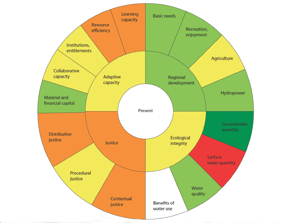
Against this background, our goal is to present a conceptual and methodological approach for an interdisciplinary sustainability assessment for water governance systems – based on what we call the sustainability wheel – and its application in the Crans-Montana-Sierre region of Switzerland, the case study area of the MontanAqua project (Weingartner et al. 2010). For this purpose, we took the basic ideas of the two approaches described above and combined them in a way that would allow the evaluation of the water governance system through a comprehensive, interdisciplinary assessment.

In this article, we use the term water governance system in a broad sense. Water governance systems are understood to include social practices and institutions, as well as biophysical aspects and processes. When using the term water resource systems, we only refer to the biophysical aspects and processes.

Download the entire article.

Weighing the benefits and costs of gene-modifying technology

View Source | July 17, 2014

James CollinsJames Collins, a senior sustainability scientist and evolutionary ecologist at ASU, leads an interdisciplinary team of researchers studying the role of host-pathogen interactions in species decline and extinction.  Through a paper published in the journal Science, the team aims to initiate a conversation about the scientific, ethical and regulatory issues that could arise from the use of a genetic engineering technology called gene drives.

Using a new genome-editing tool, scientists can, in principle, accurately insert, replace, delete or regulate genes in many different bisexual species. The technology could be used to eliminate insect-borne diseases like malaria, eradicate invasive species and reverse pesticide and herbicide resistance. Nonetheless, there are concerns regarding unexpected and possibly harmful side effects.

Collins' paper proposes instituting safety measures to control these possible effects. It suggests that gene drives be evaluated on a case-by-case basis, taking into account the trait, species and ecosystem in question. Controlled testing in laboratories located in areas where target species can’t survive and reproduce, or development of an alteration-reversing version for every single gene drive are additional examples of precautionary actions.

Bringing environmental education to children in low-income communities

July 16, 2014

Undergraduates Alexis Roeckner and Lauren Gault present interactive environmental education lessons at Homeward Bound
Undergraduates Alexis Roeckner and Lauren Gault present interactive environmental education lessons at Homeward Bound.


In Fall 2013 CAP's Ecology Explorers program began a partnership with Homeward Bound, an organization that provides transitional housing, employment services, and other forms of support to low-income families with children that are homeless, recently evicted, or fleeing a domestic violence situation. Under the direction of CAP education coordinator, Gina Hupton, undergraduate and graduate students have been designing and delivering environmental education lessons to pre-school and lower elementary level students through Homeward Bound's after school program. More ...


Scientist discusses wearable sensors at sustainable health forum

View Source | July 11, 2014

Lee HartwellLee Hartwell, distinguished sustainability scientist and chief scientist for the Center for Sustainable Health, was among the speakers at the Forum for Sustainable Health, an annual event hosted by ASU’s Center for Sustainable Health. This year, the forum served as a formal kick-off the Center's new “Project HoneyBee,” an endeavor to develop wearable sensors that improve patient outcomes while reducing costs.

According to Hartwell, who underscored the current technological challenges of the wearable sensors market, the task of will not be easy. “Within 10 years, every patient will be monitored by devices,” he says. “While there are lots of new discoveries, the translation into the clinic for utility is nearly zero. We need to create a process to make this technology reliable and useful, with new capabilities, to find out the best application that will have the greatest impact on medicine, and give patients control of their own health.”

ASU-led study represents first step toward artificial photosynthesis

View Source | July 9, 2014

photosynthesisDepartment of Chemistry and Biochemistry Professor Petra Fromme and two distinguished sustainability scientists, Tom and Ana Moore, are among the authors of a study recently published in Nature. Through snapshots obtained using the world's most powerful X-ray laser, the study presents the photosynthetic process as water is split into protons, electrons and oxygen.

This study represents a significant first step toward the development of artificial systems that not only mimic, but surpass the efficiency of natural systems. By revealing the mechanism of the water splitting process, researchers are closer to reaching one of the major goals of the ASU Center for Bio-Inspired Solar Fuel Production: the creation of an artificial leaf.

This work builds on Fromme’s earlier work, which used the same X-ray laser to determine the structure of a protein. Named by Science Magazine as one of the Top 10 Breakthroughs of 2012, researchers used 178,875 individual laser pulses to generate a diffraction pattern that helped them to decipher the protein’s structure.

Lake Mead Levels to Drop to Historic Lows

July 9, 2014

July 9, 2014

Listen to DCDC director, Dave White, discuss the regional impact of the drop in Lake Mead's water level in his interview with KJZZ's Here and Now.

July 8, 2014

via Bureau of Reclamation by Rose Davis, 702-293-8421

shutterstock_1692138LakeMead_296
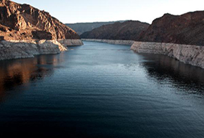
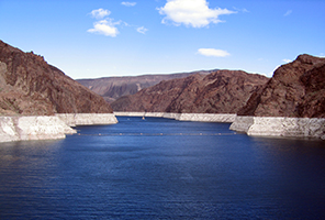
BOULDER CITY, Nev. – Lake Mead, the reservoir created by Hoover Dam, is anticipated this week to reach its lowest water level since the lake’s initial filling in the 1930s. The Bureau of Reclamation’s Boulder Canyon Operations Office is projecting the elevation to drop to 1,081.75 feet above sea level during the week of July 7 and to continue to drop, reaching approximately 1,080 feet in November of this year.

Reclamation’s Lower Colorado Region annually delivers about 9 million acre-feet (MAF) to homes, businesses, farms, Native American tribes and communities, and Mexico.

"We will meet our water orders this year and we are not projecting a shortage condition in 2015," said Lower Colorado Regional Director Terry Fulp. "We continue to closely monitor the projections of declining lake levels and are working with stakeholders throughout the Lower Basin to keep as much water in Lake Mead as we can through various storage and conservation efforts."

Annual releases from Lake Powell and Lake Mead are determined in accordance with the 2007 Colorado River Interim Guidelines for Lower Basin Shortages and Coordinated Operations for Lake Powell and Lake Mead (Guidelines). Only if Lake Mead is projected to reach elevation 1,075 feet on January 1 of each year would the Secretary of the Interior determine a shortage condition and reduce water deliveries in the Lower Basin.

Lake Mead’s elevation is currently projected to be at approximately 1,083 feet on January 1, 2015.

In Water Year 2014 (ending on September 30, 2014), Lake Powell will have released a record low amount of water, 7.48 MAF into Lake Mead in accordance with the Guidelines. As of July 1, 2014, the forecasted inflow into Lake Powell is 95 percent of average for the water year. In Water Year 2015, Lake Powell’s release to Lake Mead is currently projected to be between 8.23 MAF and 9.0 MAF.