SAN DIEGO — Officials in the seven states that depend on the drought-beset Colorado River expressed a cautious willingness Tuesday to join the federal government in a complex, possibly contentious effort to step up conservation.
At a meeting in San Diego, officials of the Department of the Interior and the Bureau of Reclamation announced the establishment of three inter-state committees to devise plans for conservation, possibly including water reuse, desalination, water banking and the sale of water from farms to cities.
“While the solutions won’t be easy for anyone involved, the consequences of failure are too dire to ignore,” said Patricia Mulroy, general manager of the Southern Nevada Water Authority.
The committees have been ordered to have their recommendations ready by year’s end — virtually lightning speed for water-sharing issues that regularly take years, often decades, to resolve, if they can be resolved at all.
One committee will be composed of major municipal and industrial water users, one of agricultural interests, and one will have representatives from environmental groups. Also, the federal government is pledging to work on conservation projects with 10 American Indian tribes that have rights to the Colorado River and its tributaries.
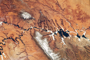
On one point, there appears to be no disagreement: The hour is late and shortages loom as demand threatens to outstrip supply. Last year was the fifth driest on record; this year is headed to be the fourth driest.
By Oct. 1, the river’s two reservoirs, Lake Mead and Lake Powell, could be at less than half of their capacity, according to the Bureau of Reclamation.
“The time for action is now,” said Jennifer Pitt, head of the Environmental Defense Fund’s Colorado River Project. “Communities that depend on the Colorado River — for water supply or as the foundation of a $26-billion recreation economy — cannot afford to wait.”
via The New York Times
By MICHAEL WINES
Published: May 19, 2013
Source: U.S. Geological Survey and The New York Times
HASKELL COUNTY, Kan. — Forty-nine years ago, Ashley Yost’s grandfather sank a well deep into a half-mile square of rich Kansas farmland. He struck an artery of water so prodigious that he could pump 1,600 gallons to the surface every minute.¶ Last year, Mr. Yost was coaxing just 300 gallons from the earth, and pumping up sand in order to do it. By harvest time, the grit had robbed him of $20,000 worth of pumps and any hope of returning to the bumper harvests of years past.
“That’s prime land,” he said not long ago, gesturing from his pickup at the stubby remains of last year’s crop. “I’ve raised 294 bushels of corn an acre there before, with water and the Lord’s help.” Now, he said, “it’s over.”
The land, known as Section 35, sits atop the High Plains Aquifer, a waterlogged jumble of sand, clay and gravel that begins beneath Wyoming and South Dakota and stretches clear to the Texas Panhandle. The aquifer’s northern reaches still hold enough water in many places to last hundreds of years. But as one heads south, it is increasingly tapped out, drained by ever more intensive farming and, lately, by drought.
Vast stretches of Texas farmland lying over the aquifer no longer support irrigation. In west-central Kansas, up to a fifth of the irrigated farmland along a 100-mile swath of the aquifer has already gone dry. In many other places, there no longer is enough water to supply farmers’ peak needs during Kansas’ scorching summers.
And when the groundwater runs out, it is gone for good. Refilling the aquifer would require hundreds, if not thousands, of years of rains.
Portions of the High Plains Aquifer are rapidly being depleted by farmers who are pumping too much water to irrigate their crops, particularly in the southern half in Kansas, Oklahoma and Texas. Levels have declined up to 242 feet in some areas, from predevelopment — before substantial groundwater irrigation began — to 2011.
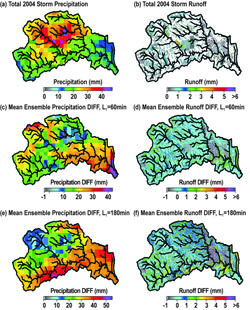
Figure 10. Spatial distribution of total (a) rainfall and (b) runoff at LTHOM during Storm 2004, 2 using QPE forcing; mean ensemble difference of precipitation for (c) 60-min and (e) 180-min 3 lead times; and mean ensemble differences of runoff for (d) 60-min and (f) 180-min lead times.Flood forecasting in mountain basins remains a challenge given the difficulty in accurately predicting rainfall and in representing hydrologic processes in complex terrain. This study identifies flood predictability patterns in mountain areas using quantitative precipitation forecasts for two summer events from radar nowcasting and a distributed hydrologic model. We focus on eleven mountain watersheds in the Colorado Front Range (CFR) for two warm-season convective periods in 2004 and 2006. The effects of rainfall distribution, forecast lead time and basin area on flood forecasting skill are quantified by means of regional verification of precipitation fields and analyses of the integrated and distributed basin responses. We postulate that rainfall and watershed characteristics are responsible for patterns that determine flood predictability at different catchment scales. Coupled simulations reveal that the largest decrease in precipitation forecast skill occurs between 15 and 45-min lead times that coincide with rapid development and movements of convective systems. Consistent with this, flood forecasting skill decreases with nowcasting lead time, but the functional relation depends on the interactions between watershed properties and rainfall characteristics. Across the majority of the basins, flood forecasting skill is reduced noticeably for nowcasting lead times greater than 30-min. We identified that intermediate basin areas (~2 to 20 km2) exhibit the largest flood forecast errors with the largest differences across nowcasting ensemble members. The typical size of summer convective storms is found to coincide well with these maximum errors, while basin properties dictate the shape of the scale dependency of flood predictability for different lead times.
(1) School of Sustainable Engineering and the Built Environment, Arizona State University, Tempe, AZ 85287
(2) Decision Center for a Desert City, Global Institute of Sustainability, Arizona State University, Tempe, AZ 85287
(3) School of Earth and Space Exploration, Arizona State University, Tempe, AZ 85287
(4) National Center for Atmospheric Research, Boulder, CO
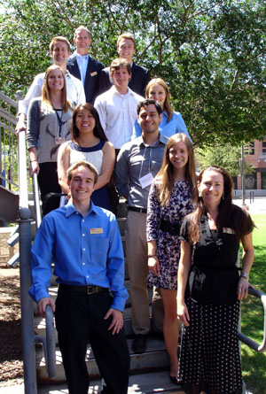
On May 1, 2013, students engaged in DCDC education programs participated in our annual poster symposium. Graduate students from the Community of Graduate Scholars program, undergraduate interns from the Internship for Science-Practice Integration program, and undergraduates working with faculty researchers as Research Experiences for Undergraduates (REU’s) presented their research results.
CGS Posters
Farmers’ Resilience to Socio-Ecological Change in Central Arizona[poster]
– Julia C. Bausch (CGS), Cathy Rubiños, Hallie Eakin, Abigail York, and Rimjhim Aggarwal
Quenching our Thirst: Future Scenarios of Water in Phoenix[poster]
– Lauren Withycombe Keeler (CGS), Arnim Wiek, Dave White, Ray Quay, David Sampson, and John Quinn
Fostering Perspective-Taking in Collaborative Decision Making through an Interactive Computer Simulation[poster]
– Rashmi Krishnamurthy (CGS), Erik W. Johnston, Manikandan Vijayakumar (CGS), and Ajay Vinze
Actual vs. Perceived Amounts of De facto Wastewater Reuse in the Continental United States[poster]
– Jacelyn Rice (CGS) and Paul Westerhoff
Cross-cultural Perspectives on Uncertainty in Climate Science: Preliminary Results from DCDC and the Global Ethnohydrology Study[poster]
– Jose Rosales Chavez (CGS), Amber Wutich, Dave White, Kelli Larson, and Alexandra Brewis
Uncertainty Frames in Water Policy Debates[poster]
– Dave White and V. Kelly Turner (CGS)
Sustainability, Collaboration and Uncertainty: A Scenario Based Evaluation of Water Issues for Desert Cities Using Computer Simulation[poster]
– Manikandan Vijayakumar (CGS), Erik Johnston, Rashmi Krishnamurthy (CGS), and Ajay Vinze
Using Structured Discussions to Explore Cross-Cutting Themes in Research at the Decision Center for a Desert City – Community of Graduate Scholars Group Poster [poster]
– Julia C. Bausch, Jacelyn Rice, Jose Rosales Chavez, Lauren Withycombe Keeler, Rashmi Krishnamurthy, Rebecca Neel, Jorge Cazáres Rodriguez, V. Kelly Turner, and Manikandan Vijayakumar
ISPI Posters
Residential Landscaping Decisions and Water Usage in the City of Phoenix[poster]
– Emily Allen, ISPI Intern with the City of Phoenix
– Doug Frost, Mentor, City of Phoenix
– Elizabeth Wentz, ASU Faculty Mentor
Analysis of Water Consumption Trends in the City of Goodyear[poster]
– Christopher Berg, ISPI Intern with the City of Goodyear
– Mark Holmes, Mentor, City of Goodyear
– Ray Quay, ASU Faculty Mentor
Implementation of Low Impact Development Paving Strategies in Central Arizona[poster]
– Erin Brechbiel, ISPI Intern with the University of Arizona Cooperative Extension
– Summer Waters, Mentor, U of A Cooperative Extension
– Abigail York, ASU Faculty Mentor
Potential Attributes of Water Use Variation in Mixed Use Residential Landscapes[poster]
– Joseph Hennessy, ISPI Intern with the City of Phoenix
– Douglas Frost and Adam Miller, Mentors, City of Phoenix
– Dave White, ASU Faculty Mentor
Modeling Well Specific Pumping at the Provider Level[poster]
– Taylor Ketchum, ISPI Intern with Arizona Department of Water Resources
– Dale Mason and Frank Corkhill, Mentors, Arizona Department of Water Resources
– David Sampson, ASU Faculty Mentor
Criteria-Based Risk Assessment for Sustainable Water Quality in Municipal Wells[poster]
– Samantha Kohlwey, ISPI Intern with the City of Mesa
– Brian Draper and Colette Moore, Mentors, City of Mesa
– Ray Quay, ASU Faculty Mentor
Complexities of Analyzing the Water/Energy Nexus in Small Hillside Water Distribution Systems[poster]
– Winnie (Ching Yan) Lau, ISPI Intern with the City of Phoenix
– Andy Terrey, Mentor, City of Phoenix
– Benjamin Ruddell, ASU Faculty Mentor
Effective Engagements at the Rio Salado Habitat Restoration Area[poster]
– Martin Montes de Oca, ISPI Intern with the University of Arizona Cooperative Extension
– Summer Waters, Mentor, University of Arizona Cooperative Extension
– Monica Elser, ASU Faculty Mentor
Effectiveness of the Modified Field Trip Curriculum: Teaching the Importance of Good Conservation Habits[poster]
– Andrew Wittig, ISPI Intern with Audubon Arizona
– Lyana Guevara, Mentor, Audubon Arizona
– Joni Adamson and Monica Elser, ASU Faculty Mentors
REU Posters
When Scientists Disagree: How We Frame Uncertainty Influences Public Trust of Science[poster]
– Rebecca Neel, Nicholas Murtha (REU), Susan Ledlow, Steven Neuberg, and Douglas Kenrick
The Future of Water in the Desert: Convergence and Divergence between Decision Makers and Students[poster]
– John Quinn (REU), Dave White, Lauren Withycombe Keeler, Arnim Wiek, and Kelli Larson
The Upside of Flip-Flopping: How Former Skeptics Can Shift Public Opinion on Climate Change[poster]
– Megan Ringel (REU), Rebecca Neel, Jaimie Krems, and Steven Neuberg
 SAN DIEGO — Officials in the seven states that depend on the drought-beset Colorado River expressed a cautious willingness Tuesday to join the federal government in a complex, possibly contentious effort to step up conservation.
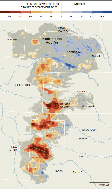
 Criteria-Based Risk Assessment for Sustainable Water Quality in Municipal Wells