by Nikki Cassis via ASU News
 Droughts are more than simply climate phenomena. They can have profound social, environmental and economic impacts, and can also be a major threat to food security throughout the world. Though much progress has been made in monitoring droughts and understanding their causes, there is still a strong need for better precision in both the monitoring and forecasting of droughts.
A team led by Arizona State University researchers seeks to enable the move from a reactive to a more proactive approach to droughts, by developing new capabilities to conduct global drought monitoring using satellite detection of water stress and hydrologic models applied at regional scales.
Under the direction of ASU hydrologist and DCDC researcher Enrique Vivoni, a contingent of ASU researchers is leading a group from NASA Ames, California State University at Monterey Bay, and a nonprofit research and development organization, known as Planetary Skin Institute (PSI), in integrating multi-resolution, remote sensing-based drought indices into an online, cloud computing-based visualization platform.
Vivoni’s research group was selected for a NASA project in the Earth Science Applications: Water Resources competition, which specifically sought projects able to leverage NASA capabilities to advance their skill to monitor, identify, assess, predict and respond to water resource deficits. The NASA project led by the ASU team will build on a concept prototype seeded by PSI.
“ASU’s portfolio of earth and space research has enabled us to compete at NASA for new efforts in the application of hydrologic remote sensing and informatics,” explains Vivoni, an associate professor in ASU’s School of Earth and Space Exploration. “We are really excited to be leading a multi-institutional project to develop drought monitoring tools. These will have applications in semiarid regions with large agricultural regions across the world, including in Arizona.
“We have selected to use a water stress index to conduct drought monitoring specifically in drought-prone areas of northwest Mexico and northeast Brazil given their critical importance,” adds Vivoni. “To do so, we will expand the capabilities of a cloud-based geospatial platform to incorporate drought products using remote sensing data and hydrologic model outputs. We hypothesize that the cloud-based platform will be a game-changing approach for drought monitoring, assessment and prediction at a range of scales.”
Teji Abraham, chief development officer for PSI, considers “the drought products from this project very complementary and important for the Open Innovation program that PSI is partnering with Brazil’s Ministry of Science, Technology, & Innovation – especially for timely risk management given the propensity of drought in northeast Brazil. In collaboration with this group of partners, PSI also intends to extend this new approach in the future to other countries in Asia and Africa that are particularly susceptible to drought.”
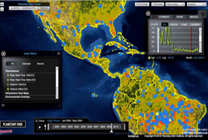
Drought products
The drought products will be spatial maps provided approximately every two weeks that will show drought severity over the two countries of interest (Brazil and Mexico) at high resolution (4 to 8 kilometers) and over the globe at lower resolution (16 to 32 km). The drought maps will be derived from satellite remote sensing observations, specifically the Moderate Resolution Imaging Spectroradiometer (MODIS) sensor on board the Earth Observing System Aqua and Terra satellites. These will be complemented with auxiliary data such as irrigation sectors, river basins, stream networks, reservoirs, political boundaries, temperature and precipitation, among others.
This data will be integrated into a cloud-based platform, called Drought ALERTS (short for Automated Land change Evaluation, Reporting and Tracking System). This global visualization system will overlay standard maps with scientific products related to natural resources management for near real-time global detection of water stress at multiple resolutions.
Targeted at national water managers, irrigation districts, policymakers and scientific communities, Drought ALERTS is designed to engage stakeholders and decision-makers in local to regional problems concerned with natural resources and risk management and will provide timely detection of drought events on a global basis with a high degree of accuracy.
“This innovative platform will utilize remote sensing products from low-Earth orbiting satellites to produce drought indices. It will help form the basis for resource allocation decisions and it will be refined over time as we find ways to make it better reflect the needs of decision-makers and others who use the information,” says Vivoni.
“PSI sees this as an important step forward in globally scaling drought monitoring capabilities. In partnership with PSI’s regional partners, we expect this project to help bridge the gap between scientists and decision makers by integrating drought data products into a decision planning environment that enables the data to be analyzed in context for making holistic decisions,” adds Abraham.
Current drought monitors, such as the US drought monitor, rely on assembling precipitation data from rain gauges throughout a region about once every week. The US drought monitor is a great resource that has improved US-based efforts with respect to what was available even five years ago; however, this can lead to large errors in developing countries as instrument networks there are sparse or inconsistent. Remote sensing products provide an alternative view of drought by making inferences based on vegetation status and land surface temperature.
Drought ALERTS, and similar products, could serve as the backbone of national drought monitoring in many developing countries to improve drought detection, awareness and decision-making capabilities. For example, the study areas in northwest Mexico and northeast Brazil are currently undergoing severe multi-year droughts affecting agricultural production. These advances can yield significant cost savings through reduced risks across several water demand sectors including food production and security, hydropower generation, and natural ecosystem services.
End users
The end users will range from local- to country-level decision-makers that are involved in water, land and natural resources management. Vivoni and his collaborators have partnered with a large irrigation district in Mexico and a federal emergency management agency in Brazil that are interested in drought forecasts.
“The Yaqui Valley Irrigation District in Sonora, Mexico is a major producer of wheat. The Center for Monitoring of Natural Disasters in Brazil is a new agency in charge of nation-wide alerts. Both of these institutions – and others that will join as the program develops – will have access to tailored scientific products related to drought,” explains Vivoni.
Users will be able to query, visualize and plot metrics that explore the different dimensions of drought, including the precipitation and temperature forcing and the vegetation response. Summary statistics, such as drought duration and intensity, will be provided to help them gauge the level of the threat.
Drought monitoring is but the first step in a larger vision. Vivoni intends to expand this drought effort into a hydrological risk monitoring platform that also deals with floods, landslides, erosion potential, etc. to provide a more complete picture of global water excess and water limitations.
“Eventually, the drought monitor will also help our undergraduate and graduate students interact, query and explore real-time remote sensing data that describe changes in the hydrological cycle over their regions of interest. By bringing research products into classroom activities, our student learning experiences will be enriched,” adds Vivoni.
 This year marked several significant milestones in leadership and administration for Decision Center for a Desert City (DCDC). In a planned transition phased in over the past year and a half, Dave White assumes the role of Principal Investigator and Director. Dave has been with DCDC since its inception; first as senior project personnel in DCDC I, then as co-PI and Associate Director for DCDC II.