City: Seattle Country / US State / US Territory: Washington Type of Solution: Vacant Properties and Lots Climate Impact: Extreme Precipitation and Flooding Social Value Created: recreation; public gathering space; social cohesion; connectivity; employment; benefits vulnerable communities
The City of Seattle recently redeveloped undertook a nine-acre redevelopment project to repurpose an underutilized parking lot and the surrounding area. The Thornton Creek restoration is one component of the restoration project. Thornton Creek was previously been forced below the surface as the urban area developed.
The restoration project aimed to restore the creek to manage stormwater runoff from 680 acres. Impervious surfaces were also reduced by 78%, improving ground water infiltration and thereby reducing runoff. Native species were used for 85% of the project’s landscaping, reducing water consumption for landscaping and reducing maintenance needs. The project design also improves stormwater filtration to remove pollutants from stormwater runoff, removing 40-80% of total suspended solids from 91% of runoff in the 680 acre drainage basin.
Thornton Place is a combined residential and commercial space created in the redevelopment. The project added 530 units of mixed-income housing and 50,000 square feet of retail space, including 143 units of assisted-living housing for seniors. Thornton Place also includes a 14-screen cinema and a plaza area for public gatherings. Additionally, pedestrian links were created to link adjacent commercial and residential neighborhoods, improving walkability. Transit access was also improve by the design, increasing mobility and diversity of transportation.
City: Cleveland Country / US State / US Territory: Ohio Type of Solution: Vacant Properties and Lots Climate Impact: Extreme Temperatures and Urban Heat Island Effect; Air Quality; Extreme Precipitation and Flooding Social Value Created: Food Security and Nutrition; Educational and Employment Opportunities; Equitable and Affordable Services; Property Values
In an effort to counteract climate impacts, such as extreme temperatures, air quality issues, and heavy precipitation flooding, Cleveland, Ohio is working on improving its urban tree canopy and urban agriculture in low-income neighborhoods. Cleveland has placed a priority on socially equitable climate adaptation solutions, seeking to have a variety of socioeconomic benefits, such as improving food security and nutrition, increasing property values, reducing energy and health costs, and promoting economic development and employment opportunities.
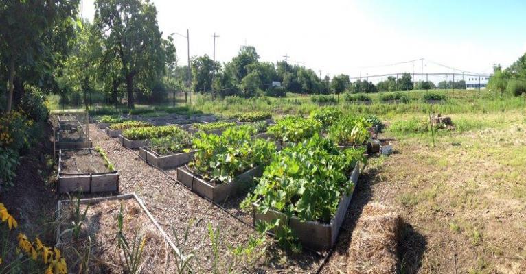
The City has already developed 300 community gardens and urban farms, many of which are located on repurposed vacant lots. One example of a vacant lot project is the 26.5 acre Urban Agriculture Innovation Zone in the Kinsman Neighborhood that includes a number of initiatives, such as the Kinsman Farm and Rid-All Green Partnership.
Kinsman Farm is a 6-acre incubator farm that was established in 2010 as part a $1.1 million dollar grant from the USDA’s as part of the Beginner Farm and Rancher Development Program. Kinsman Farm provides new urban farmers seeking to start agricultural businesses with assets such as land, infrastructure, and education. New farmers gain valuable experience and learn how to successfully grow their operations before investing in a large-scale commercial farm.
The initiative is supported by Ohio State University (OSU) Extension, West Creek Conservancy, the City of Cleveland, and Burten, Bell, Carr Development Corporation. OSU Extension provides technical support and educates farmers on best practices, West Creek Conservancy leases the property and promotes sustainable agricultural practices, and Burten, Bell, Carr Development Corporation focuses on improving residents’ quality of life through initiatives to increase access to health food.
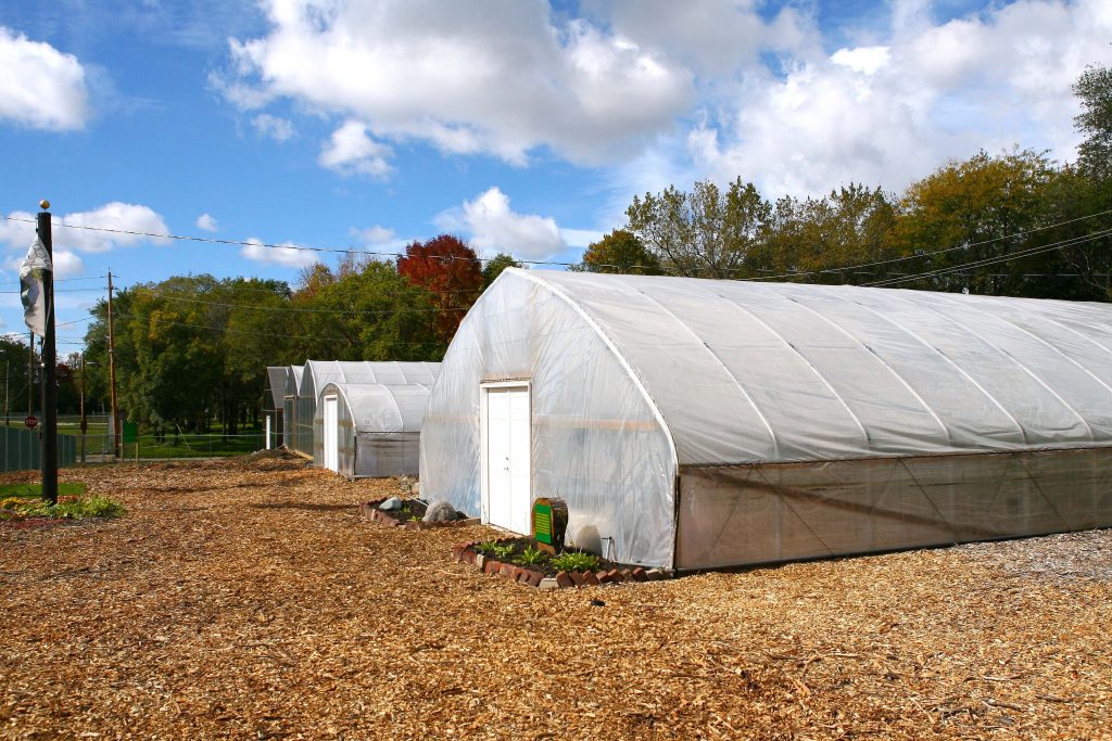
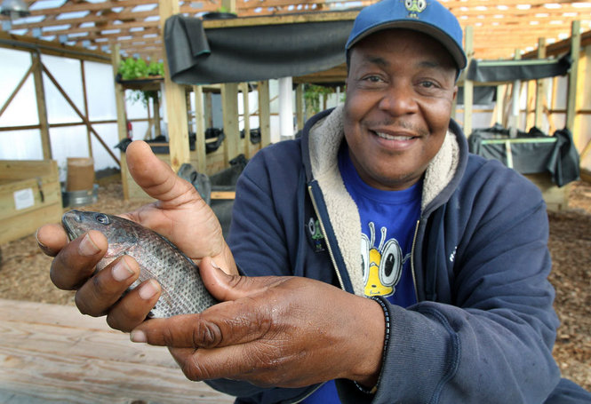
The Rid-All Green Partnership is another urban farm that occupies 1.5 acres in the Urban Agriculture Innovation Zone. The farm features two greenhouses, four hoop houses, a 40,000 square foot Aquaponics fishery, and a compost program. The compost program collects food waste from the Cleveland Food Bank, wood chips from the Cleveland Forestry Department, coffee grounds from local coffee shops, and excess hops from the Little Mountain Brewery and Black Box Brewery. In 2012, the Partnership produced 14,000 pounds of produce, raised 350 pounds of tilapia, and produced 1,200 cubic yards of compost.
The Partnership seeks to improve food security and nutrition in the local community. Additionally, the Partnership has a strong focus on community education, educating both the adult and youth population. There are a variety of education programs, including the Five Month Training Program, Weekend Workshops, Victory Garden Initiative, Ohio Apprenticeship Program, and Youth Educational Program.
Fig: Kinsman Farm. (Photo retrieved from https://cuyahoga.osu.edu/program-areas/agriculture-and-natural-resources/market-gardening-and-urban-farming/kinsman-farm – No longer an active link) Fig: Rid-All Green Partnership urban farm (Photo retrieved from https://www.greennghetto.org/?page_id=89) Fig: Man holding Tilapia raised by the Rid-All Green Partnership (Photo retrieved from https://www.greennghetto.org/?attachment_id=184).
OSU Extension. (n.d.). Kinsman Farm. Retrieved from https://cuyahoga.osu.edu/program-areas/agriculture-and-natural-resources/market-gardening-and-urban-farming/kinsman-farm. No longer an active link
City: Atlanta Country / US State / US Territory: Georgia Type of Solution: Vacant Commercial Properties and Lots Climate Impact: Extreme Temperatures and Urban Heat Island Effect; Air Quality; Extreme Precipitation and Flooding Social Value Created: Social Cohesion; Quality of Life; Public Health and Safety; Diverse Transportation; Historic Preservation; Public Spaces; Active Living and Playspaces
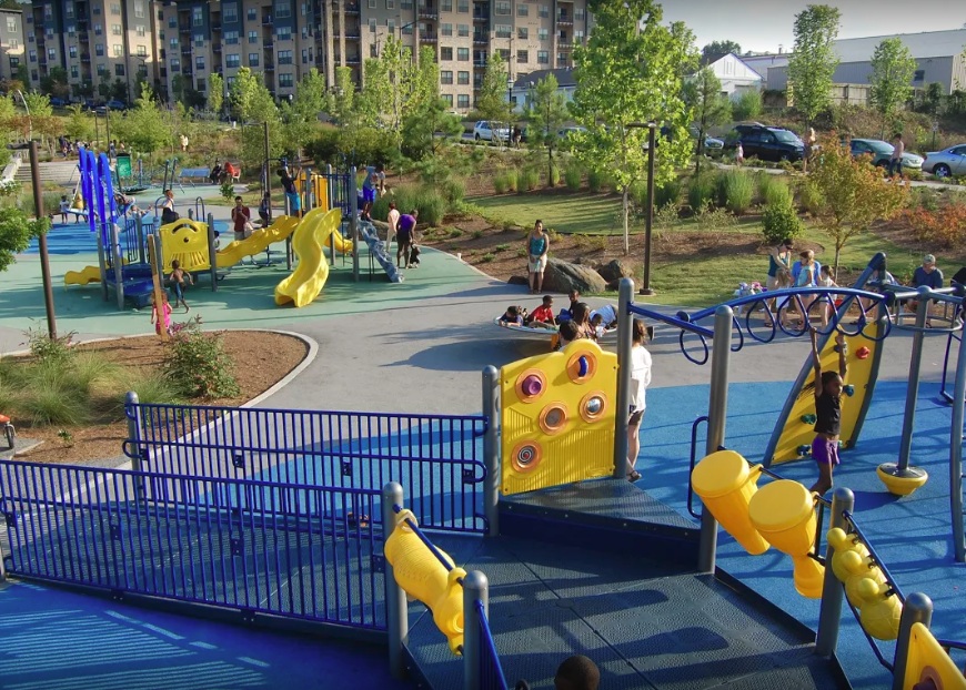
A former industrial and commercial property has been revitalized to become a 17-acre urban park, Historic Fourth Ward Park. The park is adjacent to the Atlanta BeltLine project, a rails to trails project that is restoring 22 miles of abandoned railway beds into recreational trails and a streetcar line. The $ project was completed in 2011, and the use of green infrastructure opposed to traditional gray infrastructure drainage system the city is estimated to have saved $15 million.
The park is located in an area that historically has experienced flooding and sewer overflows during storms. The green infrastructure system, consisting of bioretention, underground cisterns, and pervious surfaces, will help to improve stormwater management, with the capacity to capture runoff for a 100-year storm. Preventing sewer overflows helps to counteract the spread of waterborne diseases, contributing to public health.
One of the park’s features is a two-acre stormwater detention pond, Clear Creek Basin, which has already helped to reduce flooding in the surrounding neighborhoods. The Basin not only reduces flooding, but it also acts as a water reserve providing 425 gallons per minute even during a drought. The Basin was designed to use plantings and landscaping strategies used in wetlands.
Additionally, the greenspace improves air quality and contributes to urban cooling, mitigating extreme temperatures and the urban heat island effect. Trees and play structures increase shade, improving the comfort of community members and their overall quality of life.
In addition to improved stormwater management, a previously underutilized space is now creating social value for the community. The park provides community gathering space, contributing to social cohesion. In the park there is a playground and splash pad for children to play, which helps to keep children physically active, improving children’s health. The park also provides recreational paths for biking and walking, contributing to diversity of transportation.
Sources:
The Environmental Protection Agency. (2017). Green infrastructure in parks: a guide to collaboration, funding, and community engagement. Retrieved from http://www.adaptationclearinghouse.org/resources/green-infrastructure-in-parks-a-guide-to-collaboration-funding-and-community-engagement.html