Valdivia, Chile: Parque Urbano Catrico

City: Valdivia
Country / US State / US Territory: Chile
Type of Solution:
Climate Impact: Extreme Precipitation and Flooding
Social Value Created: Public Spaces; Public Education and Awareness; Social Justice and Equity; Public Health and Safety

In Valdivia, wetland areas have been an issue for residents. Many low-income communities are located adjacent to wetland areas, which are generally sites for illicit activities and dumping. Additionally, many residents do not have accessible areas of greenspace.

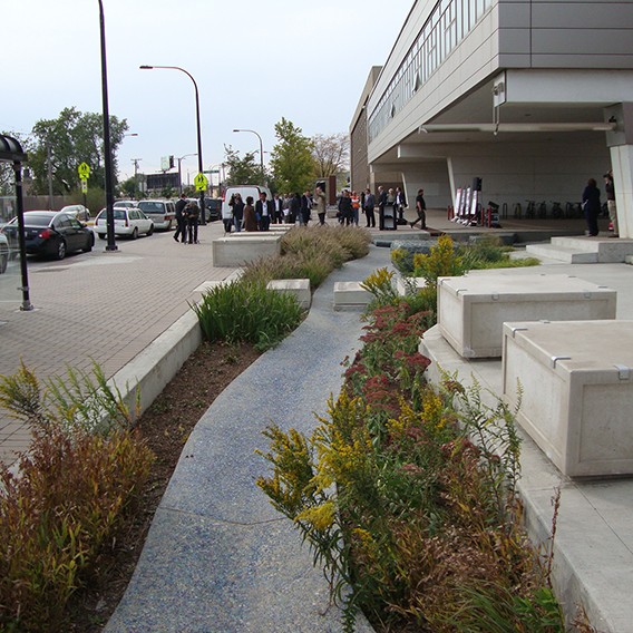
Valdivia is undertaking projects to convert these wetland areas into parks that are more accessible and are better illuminated, which help to protect a valuable stormwater management asset. Converting these areas mitigates illicit activities and illegal dumping in these vulnerable communities.

One example of a park developed in a wetland area is Parque Urbano Catrico. The park is surrounded by low-income communities, and these communities are the first to have problems during extreme events. Thus, these communities are the first people engaged in the process. In the Parque Urban Catrico project, many residents are requesting grey infrastructure. However, the architects designing the process are working on educating residents on the benefits of green infrastructure, helping to improve public education and awareness.

San Juan, Puerto Rico: Canyo Martin Pena and Enlace

City: San Juan
Country / US State / US Territory: Puerto Rico
Type of Solution: Community Group
Climate Impact: Extreme Precipitation and Flooding
Social Value Created: Public Education and Awareness; Safe and Affordable Housing; Public Health and Safety

Canyo Martin Pena and Enlace is an informational project established by the community to help mobilize community members to address mismanaged land. The community has experience flooding problems and water quality issues.

Dredging the canal would help to address flooding, community health issues, and improve water quality. Additionally, the community faces issues around land rights and the area is facing climate gentrification. Canyo Martina Pena and Enlace are also working to address these issues around housing, equity, and land titles as they work to address climate impacts.

Miami, Florida: King Tide Outreach Program

City: Miami
Country / US State / US Territory: Florida
Type of Solution: Awareness Campaign
Climate Impact: Sea level rise and inundation, extreme precipitation and flooding, hurricanes and storm surge
Social Value Created: Public Education and Awareness; Community Engagement; Social Justice and Equity for Vulnerable Communities

Many coastal areas are currently privately owned. Miami is low lying, so both coastal and non-coastal areas will flood due to sea level rise, heavy precipitation events, and hurricanes and storm surge. The King Tide Outreach Program is an awareness campaign launched by the City of Miami. Community non-profits partnered with the City of Miami to hold the campaign.

Last fall, the King Tide Outreach Program focused on educating Shore Crest, a mixed income and diverse neighborhood. Many residents are renters and are unaware of the causes of flooding. Residents have had issues with being able to go to work during flooding events.

The campaign engaged in a number of outreach activities, including social media, door to door messaging, and distribution of digital flyers. The City of Miami used Facebook and Twitter messages to communicate information to followers. The Facebook page has 6,423 followers, and the Twitter page has 111,000 followers. A Youtube video titled, “City of Miami – King Tides in Shorecrest,” was created as another educational communication during a Citizen Science collection day. The video has received 1,325 views thus far.

Prior to each King Tide event, messages were posted on New Door to directly reach City of Miami residents. An estimated 15,500 residents were reached for Citywide King Tide messages, and an estimated 125 residents were reached in the targeted Shorecrest/Haynsworth Village messages.

The Upper Eastside NET office served as an outreach post for Shorecrest residents, providing King Tide information and resources. Between 10 to 15 residents contacted the NET Offices for more information about the King Tides. Additionally, four community meetings were held and seven variable message signs were placed around the city to warn of King Tides.

Fig: Example of digital flyer distributed via Twitter, showing safety information on the front (left) and a map of affected areas on the back (left) (Image retrieved from https://twitter.com/CityofMiami/status/926777359327547392)

Sources

*Note: This case was documented from an interview with a city practitioner.

Miami, Florida: CLEAR Miami

City: Miami
Country / US State / US Territory: Florida
Type of Solution: Volunteer / Community Group Program
Climate Impact: Seal Level Rise; Hurricanes and Storm Surge; Extreme Heat and Urban Heat Island Effect; Infectious Disease
Social Value Created: Public education and awareness, community engagement, social cohesion, benefits vulnerable communities

Catalyst Miami is a community organization that has conventionally focused on providing social services, such as health coaching and financial planning. Recently, the group has begun to engage vulnerable communities in local climate initiatives.

In 2016, Catalyst Miami launched its CLEAR Miami (Community Leadership on the Environment, Advocacy, and Resilience) program. CLEAR Miami is a 12 week program that teaches residents how to participate in the climate planning process, including the basics of climate change science, types of adaptation strategies, communication skills for public speaking, and how to create an asset map for their neighborhoods.

Community members learn about the risk of Seal Level Rise and Inundation, hurricanes and storm surge, extreme heat and the urban heat island effect, and the spread of infectious disease. The program focuses on financially vulnerable populations given their disproportionate level of risks to climate impacts. Those who participate in the program are provided dinner and childcare for free.

The Southeast Florida Climate Compact is working on updating an adaptation plan and developing a mitigation plan. Catalyst Miami is working on engaging residents in this planning process to ensure equitable solutions are chosen.

Fig: The first CLEAR Miami graduates (Photo retrieved from https://catalystmiami.org/climate-resilience-local-engagement/)

Fig: CLEAR Miami Youth graduates talking about why they advocate for climate change (Photo retrieved from https://catalystmiami.org/climate-resilience-local-engagement/)

Sources: Delahunty, M. (2016). Catalyst Miami launches pioneering climate resilience training in South Florida. Catalyst Miami. Retrieved from

United States Water Alliance. (2017). An equitable water future: a national briefing paper. Retrieved from http://uswateralliance.org/sites/uswateralliance.org/files/publications/uswa_waterequity_FINAL.pdf

*Note: This case was documented from an interview with a city practitioner.

Los Angeles, California: Green Alley

City: Los Angeles
Country / US State / US Territory: California
Type of Solution: Alleyway
Climate Impact: Extreme Temperatures and Urban Heat Island Effect; Air Quality; Extreme Precipitation and Flooding
Social Value Created: Connectivity; Diverse Transportation; Public Health and Safety; Community Engagement; Social Cohesion; Arts and Culture; Public Education and Awareness

Los Angeles has over 900 of miles of alleys that are often used for dumping and experience high instances of crime. The Trust for Public Land Climate Smart Cities program is a national program for assisting cities in projects to mitigate and adapt to climate change. The Avalon Green Alley Demonstration project repurposed a mile of underutilized alleyways in South Los Angeles into green alleys.

The Trust for Public Land Climate Smart Cities collaborated with the City of Los Angeles, UCLA, and Arizona State University to create green alleys in South Los Angeles. These green alleys improve air quality and contribute to urban cooling, mitigating extreme temperatures and the urban heat island effect.

The green alley also helps to filter pollutants from stormwater runoff and control stormwater, mitigating flooding and recharging the groundwater. Additionally, the repurposed alleyways provide recreational space and improve the walkability and bikeability of the area. The green alley creates a safe passageway between various key destinations in the area, including a grocery store and nearby schools. The safe passageway improves community connectivity.

A volunteer group, Equipo Verde (Green Team), manages the green alley, organizing volunteer days, picking up garbage, and landscaping and planting trees. The group improves community engagement and educates the local community on the importance of managing these alleyways.

Fig: The Green Alley Demonstration Project completed by The Trust for Public Land (Retrieved from https://www.tpl.org/green-alleys#sm.0000ca4mkgzx8en8zd02b2m3nuov7)

Fig: Members of Equipo Verde working on the landscaping in the green alley (Retrieved from https://www.tpl.org/verde#sm.0000ca4mkgzx8en8zd02b2m3nuov7)

Sources: The Trust for Public Land. (March 17, 2016). Meet the Equipo Verde: allies for alleys. Retrieved from https://www.tpl.org/verde#sm.0000ca4mkgzx8en8zd02b2m3nuov7.

The Trust for Public Land. (n.d.). Green alleys. Retrieved from https://www.tpl.org/green-alleys#sm.0000ca4mkgzx8en8zd02b2m3nuov7.

Hermosillo, Mexico: Community Monitoring System for Heat Waves

City: Hermosillo
Country / US State / US Territory: Mexico
Type of Solution: Community Group
Climate Impact: Extreme Heat and Urban Heat Island Effect
Social Value Created: Public Education and Awareness; Community Engagement

The City of Hermosillo has begun to make improvements to accessibility of weather data. Weather data is now available once a day with weather predictions for the following day. However, the data provided to residents is minimal and are inadequate in alerting residents of dangerous heat waves.

A citizen monitoring program was in summer 2018 to empower local citizens to create their own early warning system. The city was divided into nine sectors, and mothers, the head of the households, were recruited to help develop a map of thermal exposure around the city and understand when and how long heat waves are occurring. The mothers help to collect and interpret data for air temperature and pollution. When a heat wave occurs, the mothers act as the early warning system in their neighborhoods, sharing the information with family, friends, and neighbors.

The program will be supported next summer and will provide participants with monitoring devices and cellphones to check the temperature and inform others. The goal of the program is the empower the community members to protect themselves through improved public education and awareness.

Chicago, Illinois: Urban Forest Initiative

City: Chicago
Country / US State / US Territory: Illinois
Type of Solution: Streets and Parking Lots
Climate Impact: Extreme Temperatures and Urban Heat Island Effect; Air Quality; Extreme Precipitation and Flooding; Invasive Species and Pests
Social Value Created: Public Education and Awareness; Community Engagement

The Chicago Regional Trees Initiative is working to increase the tree canopy in the city area. Increasing the tree canopy will help to mitigate extreme temperatures and the urban heat island (UHI) effect, as well as to improve stormwater management to prevent flooding during heavy precipitation events.

Additionally, pest resistant species are being selected to reduce vulnerability to invasive species, such as the Emerald Ash Borer. The city has lost 13 million ash trees already from the Emerald Ash Borer. Members of the initiative help to teach communities how to plan and care for trees, increasing community education and engaging community members.

Further, the initiative is working on incorporating vulnerability into its plans for tree plantings. The Urban Forestry Climate Change Response Framework vulnerability assessment is referenced by the initiative. The framework examines social factors of adaptive capacity, examining aspects such as the value of trees to residents, volunteer base size, and presence of incentives to increase public participation and interest. This framework also recommends a community vulnerability workshop to assist in evaluating vulnerability, educating community members and engaging them in the project.

Fig: Chicago Regional Trees Initiative members teaching residents how to properly plant and care for trees

Sources:
Brandt, L.; Scott, L.; Derby Lewis, A.; Darling, L.; Fahey R. 2016. Lessons learned from the
Urban Forestry Climate Change Response Framework. Houghton, MI: Northern Institute of Applied Climate Science. 36 pp.

U.S. Climate Resilience Toolkit. (n.d.). Fortifying Chicago’s urban forest. Retrieved from https://toolkit.climate.gov/case-studies/fortifying-chicagos-urban-forest.

Chicago, Illinois: Pilsen Sustainable Streets

City: Chicago
Country / US State / US Territory: Illinois
Type of Solution: Streets and Parking Lots
Climate Impact: Extreme Temperatures and Urban Heat Island Effect; Extreme Precipitation and Flooding
Social Value Created: Public Health and Safety; Water Security and Quality; Diverse Transportation; Public Education; Public Education and Awareness; Community Wellbeing and Quality of Life

The Chicago Department of Transportation (CDOT) implemented the Pilsen Sustainable Streets project in 2012. The project uses permeable pavement and green infrastructure, such as bioswales and rain gardens, manage projected increases in heavy precipitation and flooding. Stormwater filtration helps to remove pollutants, improving water quality. The City of Chicago has a combined sewer system, making the ability to effectively manage stormwater essential to protecting public health.

Additionally, green infrastructure contributes to improved air quality and urban cooling, counteracting extreme temperatures and the urban heat island effect. The area of vegetative landscapes and tree canopy were increased by 131%, providing more shaded areas, lowering the temperature, and increasing stormwater filtration. Increased shade and lowered temperatures improves comfort of community members and improves public health.

The project also resulted in creation of social value. A pedestrian refuge island was installed in Cermak Road and curb-corner extensions were created to improve pedestrian safety. Community outreach and education is another key feature of the project. Educational kiosks, a walking tour brochure, and a guidebook are available for community members to learn about the sustainable best practices employed by the project. These kiosks are powered by solar and wind energy.

Fig: Example of green infrastructure used in Pilsen Sustainable Streets project (Retrieved from https://www.wightco.com/work/pilsen-sustainable-street/)

Fig: LED light pole and educational kiosk (Retrieved from https://iitbuildingscience.wordpress.com/2013/09/09/greenest-sustainable-street-in-america/)

Fig: Walking tour educational brochure (Retrieved from https://www.wightco.com/projects/cermak-road-streetscape)

Sources: The Adaptation Clearinghouse. (May 13, 2016). Pilsen Sustainable Streets (Chicago, Illinois Department of Transportation. Retrieved from http://www.adaptationclearinghouse.org/resources/pilsen-sustainable-streets-chicago-illinois-department-of-transporation.html

The City of Chicago. (October 9, 2012). Transportation: City Unveils “Greenest Street in America” in Pilsen Neighborhood. Retrieved from https://www.cityofchicago.org/city/en/depts/cdot/provdrs/conservation_outreachgreenprograms/news/2012/oct/cdot_opens_the_pilsensustainablestreet.html.

Rotenberk, L. (October 8, 2012). The greenest mile: Chicago pushes the limits on sustainable streets. Grist Magazine. Retrieved from https://grist.org/cities/the-greenest-mile-chicago-pushes-the-limits-on-sustainable-streets/

Chicago, Illinois: Cooling and Warming Centers

City: Chicago
Country / US State / US Territory: Illinois
Type of Solution: Cooling and Warming Centers
Climate Impact: Extreme Temperatures and Urban Heat Island Effect
Social Value Created: Public Education and Awareness; Social Justice and Equity for Vulnerable Communities
Cost: $500,000

Extreme heat preparedness is a major focus of climate adaptation in Chicago, Illinois. In 1995, there was an extreme heat event in Chicago that killed several hundred people. As climate change progresses, extreme heat will become an even more prominent issue.

Centers have been opened to help counteract extreme temperature events. During summer months these centers act as cooling centers, and in the winter months these centers act as warming centers. The program focuses on outreach to populations vulnerable to extreme temperatures, such as the elderly.

The City partnered with the Field Museum to develop an outreach program to educate vulnerable populations on extreme temperature risks and how to prepare for extreme temperature events.

Fig: Graphic of projected urban heat island effect as a result of climate change (Image retrieved from https://www.epa.gov/arc-x/chicago-il-adapts-improve-extreme-heat-preparedness)

Fig: A woman entering a Chicago Cooling Center (Photo retrieved from https://www.the-atlas.com/project?id=239)

Sources: Atlas. (n.d.). Chicago Cooling Centers. Retrieved from https://www.the-atlas.com/project?id=239.

United States Environmental Protection Agency. (November 13, 2017). Chicago, IL adapts to improve extreme heat preparedness. Retrieved from https://www.epa.gov/arc-x/chicago-il-adapts-improve-extreme-heat-preparedness.