City: San Diego Country / US State / US Territory: California Type of Solution: Awareness Campaign / Community Outreach and Education Program Climate Impact: Extreme Temperatures and Urban Heat Island Effect; Air Quality; Extreme Precipitation and Flooding Social Value Created: Community Engagement; Public Education; Public Health and Safety; Equitable Services and Access; Social Justice and Equity for Vulnerable Communities
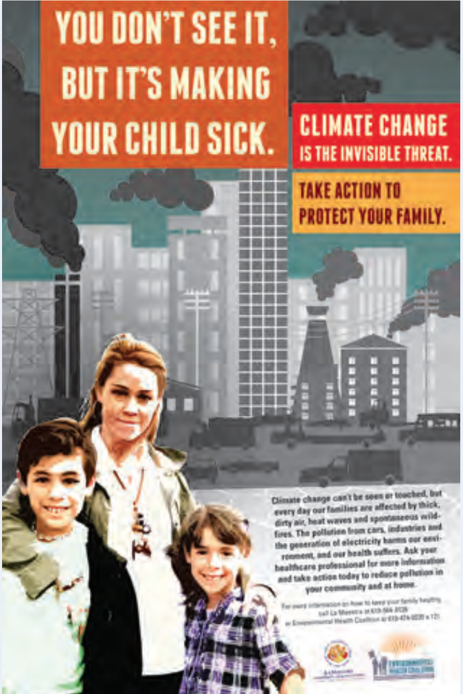
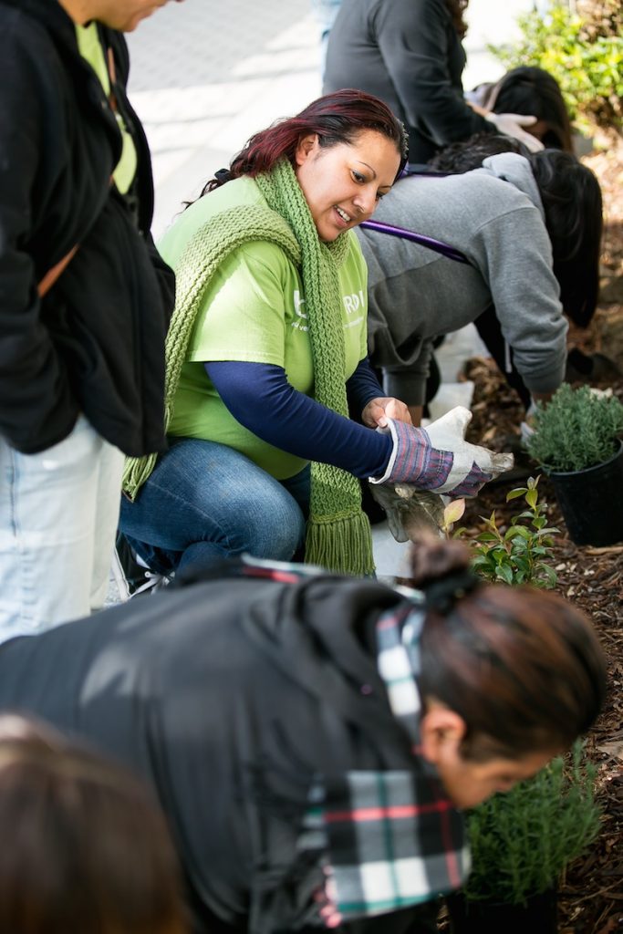
The Environmental Health Coalition is a community-based organization focusing on bringing climate justice to low-income communities of immigrants and refugees in San Diego, California. The program has developed bilingual education materials, such as brochures, posters, and promotoras, about air pollution, climate change, and climate impacts. These materials focus on solutions community members can implement that will also save money.
EHC has also facilitated the development of a climate action plan for these communities, focusing on transportation justice, energy justice, good jobs, climate change resilience, and bold goals, state, and local climate laws.
Fig: Example of a sign used to communicate the health risks of climate change
City: Portland Country / US State / US Territory: Portland Type of Solution: N/A Climate Impact: Extreme Precipitation and Flooding, Air Quality Social Value Created: Public Spaces; recreation, arts and culture; active living; transportation diversity
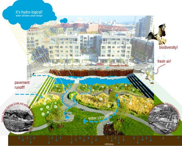
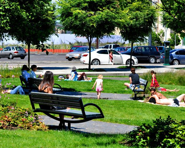
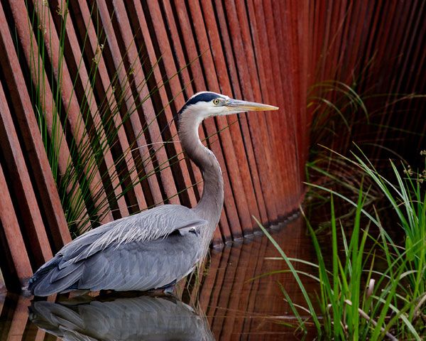
Tanner Springs Park is a park located in Portland, Oregon. The park mimics a wetland that captures and filters stormwater, reducing flooding during extreme precipitation events and improving water quality. Additionally, the wetland helps to improve air quality. The wetland design helps to promote biodiversity, as well.
The project also provides the community with accessible public space and has a number of social benefits for the community. Tanner Springs Park features a boardwalk and art installation on the east side of the park, and there is a recreational path running through the central area of the park. The art installation contributes to the community’s arts and culture. Recreational trails contribute to active lifestyles, as well as improve walkability and bikeability that contributes to diversity of transportation.
Community members were also engaged in the design process through surveys and planning charrettes in order to provide socially valuable features for that particular community.
City: Phoenix Country / US State / US Territory: Arizona Type of Solution: Volunteer / Community Group Climate Impact: Extreme Temperatures and Urban Heat Island Effect; Air Quality; Extreme Precipitation and Flooding Social Value Created: Social Justice and Equity for Vulnerable Communities; Community Engagement; Public Education; Diverse Transportation; Public Health and Safety; Urban Beautification; Community Wellbeing and Quality of Life
The City of Phoenix is participating in the national Resilience AmeriCorps program. The local program is called Resilient PHX. Volunteers assist low-income communities with projects to build community capacity. Resilient PHX has already completed a number of projects, such as Grandview Message Boards, Grand Avenue Curb Cut/Rain Garden, and Triangle Tree Planting.
Three message boards were installed in the Grandview Neighborhood to improve communication of climate risks, such as the risks of extreme heat in vulnerable communities, specifically low-income residents, elderly residents, and renters.
Another project was the Grand Avenue Curb Cut/Rain Garden. The curb cut/rain garden improves stormwater management to prevent flooding risks during heavy precipitation events. In addition to improved stormwater management, the project created more greenspace for residents and improved aesthetics, walkability, and shade coverage.
Lastly, the Triangle Tree Planting project was a community outreach program that engaged residents in tree planting and taught residents tree maintenance in an effort to mitigate extreme heat and the heat island effect. Trees increase shade coverage, which also contributes the the walkability of the area.
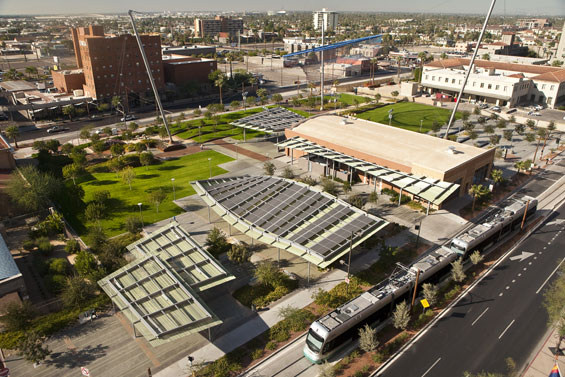
City: Phoenix Country / US State / US Territory: Arizona Type of Solution: Park Climate Impact: Extreme Temperatures and Urban Heat Island Effect; Air Quality; Extreme Precipitation and Flooding Social Value Created: Public Space; Social Cohesion; Diverse Transportation; Connectivity; Active Living and Recreation; Arts and Culture
Phoenix, Arizona is a classic example of urban sprawl. The city is already facing issues with extreme temperatures, which is further amplified by the urban heat island effect. Civic Space Park is a 2.7 acre park located in Phoenix that includes green space with trees to mitigate extreme temperatures and provide shade for residents. Solar panels producing 75 kilowatts of renewable energy provide additional shade. Also, the green infrastructure improves stormwater management, which is helpful during monsoon season.
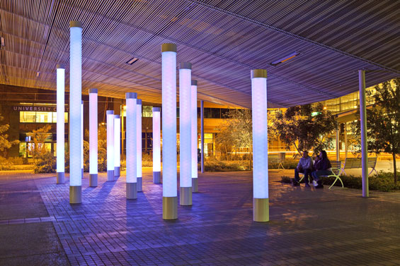
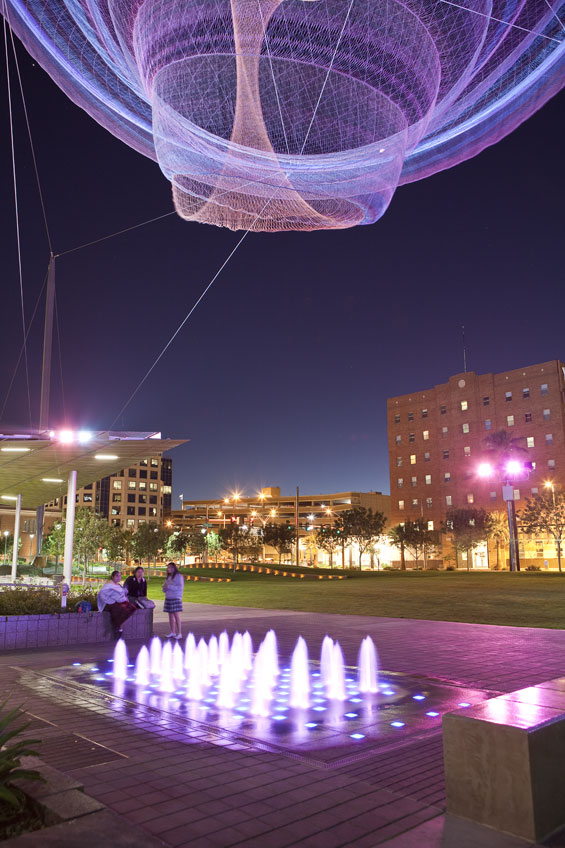
Not only is the park helpful in managing climate risks, but the park is a public space contributing the social cohesion and providing a number of other social benefits. The park features a number of artistic featurings, including a nighttime lighting show simulating lightning during a monsoon and an art installation, titled, “Her Secret is Patience.” This title arose from a phase used by Ralph Waldo Emerson that was inspired by elements of Arizona nature. There is also an interactive water feature, providing a playspace for children and adults.
The park promotes recreation and leisure, providing a turf landscape in the southwest corner of the park with pedestrian-scale retaining walls, game tables, benches, and densely spaced shade trees. The site is also located adjacent to the METRO Light Rail, increasing access to the park through improved connectivity and promoting diverse transportation.
City: Los Angeles Country / US State / US Territory: California Type of Solution: Alleyway Climate Impact: Extreme Temperatures and Urban Heat Island Effect; Air Quality; Extreme Precipitation and Flooding Social Value Created: Connectivity; Diverse Transportation; Public Health and Safety; Community Engagement; Social Cohesion; Arts and Culture; Public Education and Awareness
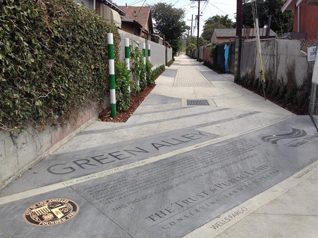
Los Angeles has over 900 of miles of alleys that are often used for dumping and experience high instances of crime. The Trust for Public Land Climate Smart Cities program is a national program for assisting cities in projects to mitigate and adapt to climate change. The Avalon Green Alley Demonstration project repurposed a mile of underutilized alleyways in South Los Angeles into green alleys.
The Trust for Public Land Climate Smart Cities collaborated with the City of Los Angeles, UCLA, and Arizona State University to create green alleys in South Los Angeles. These green alleys improve air quality and contribute to urban cooling, mitigating extreme temperatures and the urban heat island effect.
The green alley also helps to filter pollutants from stormwater runoff and control stormwater, mitigating flooding and recharging the groundwater. Additionally, the repurposed alleyways provide recreational space and improve the walkability and bikeability of the area. The green alley creates a safe passageway between various key destinations in the area, including a grocery store and nearby schools. The safe passageway improves community connectivity.
A volunteer group, Equipo Verde (Green Team), manages the green alley, organizing volunteer days, picking up garbage, and landscaping and planting trees. The group improves community engagement and educates the local community on the importance of managing these alleyways.
City: Houston Country / US State / US Territory: Texas Type of Solution: Streets and Parking Lots Climate Impact: Hurricanes and Storm Surge; Extreme Precipitation and Flooding; Air Quality Social Value Created: Diverse Transportation; Urban Beautification; Public Health and Safety; Water Security and Quality Cost: $9.6 million
Funding:
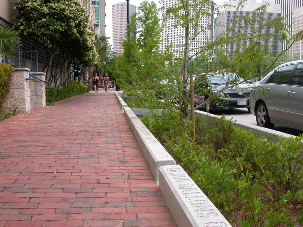
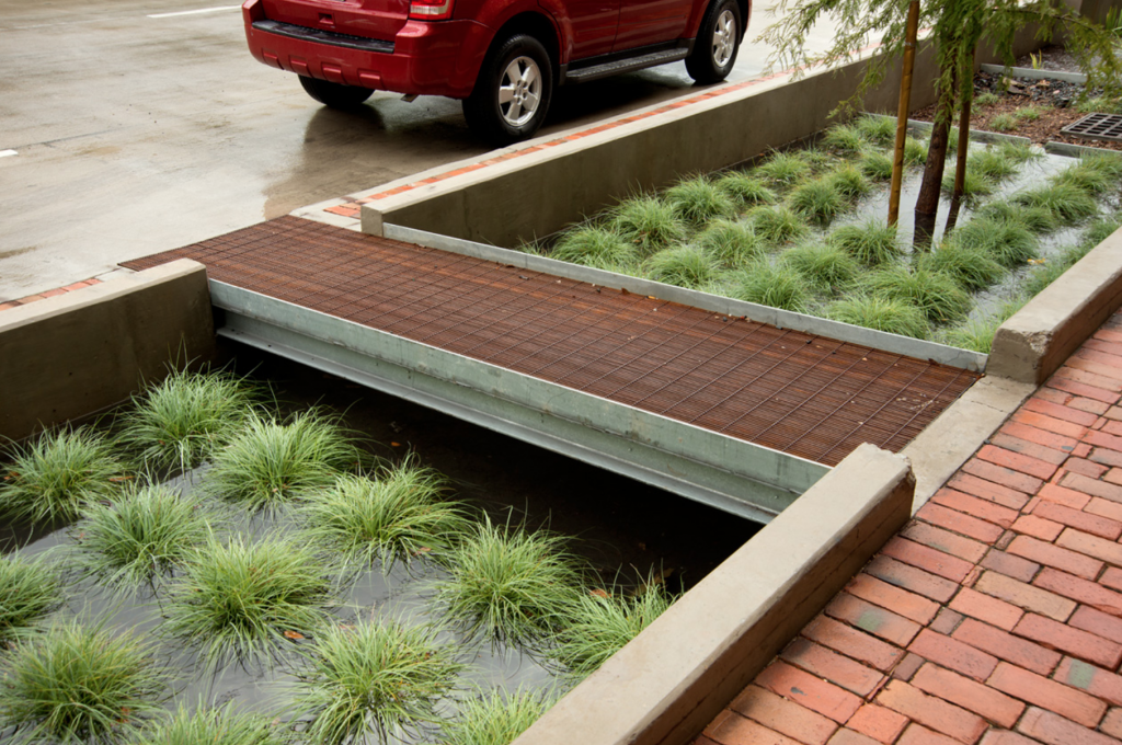
Bagby Street, a ten-block corridor in a dense, urban neighborhood underwent a redevelopment project. The project improved stormwater management to reduce flooding risks during hurricanes and severe storms. Green infrastructure systems were used to store and filter runoff, reducing flooding risk and improving water quality. The system has a smaller footprint than typical biofiltration systems, requiring only 1/20th of the space. 33% of stormwater runoff is captured by the system, removing 75% bacteria, 73% phosphorous, 93% oil and grease, 43% nitrogen, and 85% total suspended solids. Trees were also planted to aid with stormwater management, increasing the number of trees by 165%.
Additionally, the project improved traffic congestion and walkability, as well as the overall aesthetic appeal of the road, contributing to diverse transportation, public health and safety, and urban beautification. The smaller footprint design was essential for managing stormwater given the limited space available for green infrastructure. Private development also increased as a result of the project, totaling to $25 million in new development.
Sources: Atlas. (n.d.). Lower footprint biofiltration to increase efficiency in right of way stormwater capture. Retrieved from https://www.the-atlas.com/project?id=341#.
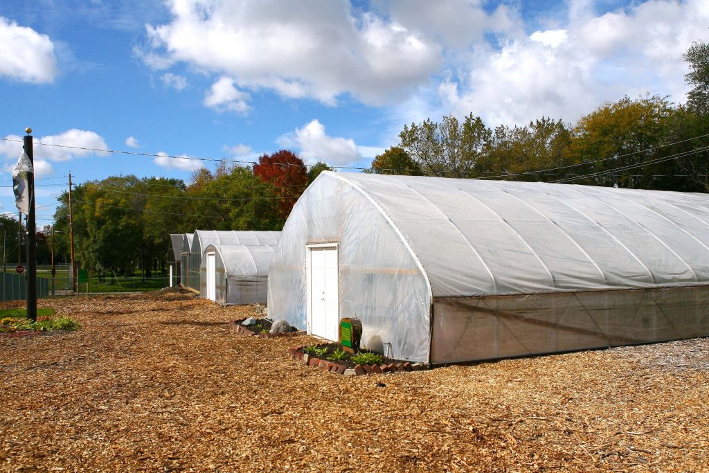
City: Cleveland Country / US State / US Territory: Ohio Type of Solution: Vacant Properties and Lots Climate Impact: Extreme Temperatures and Urban Heat Island Effect; Air Quality; Extreme Precipitation and Flooding Social Value Created: Food Security and Nutrition; Educational and Employment Opportunities; Equitable and Affordable Services; Property Values
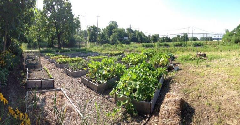
In an effort to counteract climate impacts, such as extreme temperatures, air quality issues, and heavy precipitation flooding, Cleveland, Ohio is working on improving its urban tree canopy and urban agriculture in low-income neighborhoods. Cleveland has placed a priority on socially equitable climate adaptation solutions, seeking to have a variety of socioeconomic benefits, such as improving food security and nutrition, increasing property values, reducing energy and health costs, and promoting economic development and employment opportunities.
The City has already developed 300 community gardens and urban farms, many of which are located on repurposed vacant lots. One example of a vacant lot project is the 26.5 acre Urban Agriculture Innovation Zone in the Kinsman Neighborhood that includes a number of initiatives, such as the Kinsman Farm and Rid-All Green Partnership.
Kinsman Farm is a 6-acre incubator farm that was established in 2010 as part a $1.1 million dollar grant from the USDA’s as part of the Beginner Farm and Rancher Development Program. Kinsman Farm provides new urban farmers seeking to start agricultural businesses with assets such as land, infrastructure, and education. New farmers gain valuable experience and learn how to successfully grow their operations before investing in a large-scale commercial farm.
The initiative is supported by Ohio State University (OSU) Extension, West Creek Conservancy, the City of Cleveland, and Burten, Bell, Carr Development Corporation. OSU Extension provides technical support and educates farmers on best practices, West Creek Conservancy leases the property and promotes sustainable agricultural practices, and Burten, Bell, Carr Development Corporation focuses on improving residents’ quality of life through initiatives to increase access to health food.
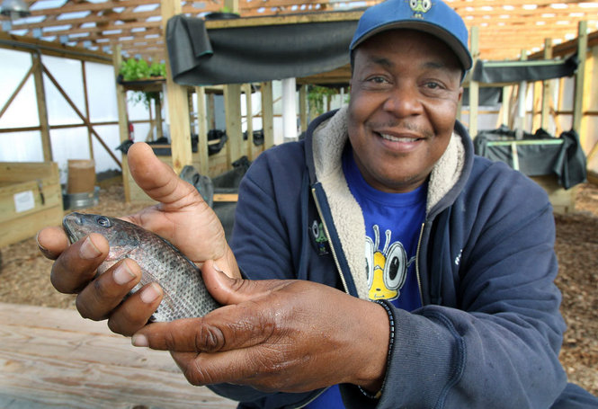
The Rid-All Green Partnership is another urban farm that occupies 1.5 acres in the Urban Agriculture Innovation Zone. The farm features two greenhouses, four hoop houses, a 40,000 square foot Aquaponics fishery, and a compost program. The compost program collects food waste from the Cleveland Food Bank, wood chips from the Cleveland Forestry Department, coffee grounds from local coffee shops, and excess hops from the Little Mountain Brewery and Black Box Brewery. In 2012, the Partnership produced 14,000 pounds of produce, raised 350 pounds of tilapia, and produced 1,200 cubic yards of compost.
The Partnership seeks to improve food security and nutrition in the local community. Additionally, the Partnership has a strong focus on community education, educating both the adult and youth population. There are a variety of education programs, including the Five Month Training Program, Weekend Workshops, Victory Garden Initiative, Ohio Apprenticeship Program, and Youth Educational Program.
Fig: Kinsman Farm. (Photo retrieved from https://cuyahoga.osu.edu/program-areas/agriculture-and-natural-resources/market-gardening-and-urban-farming/kinsman-farm – No longer an active link) Fig: Rid-All Green Partnership urban farm (Photo retrieved from https://www.greennghetto.org/?page_id=89) Fig: Man holding Tilapia raised by the Rid-All Green Partnership (Photo retrieved from https://www.greennghetto.org/?attachment_id=184).
OSU Extension. (n.d.). Kinsman Farm. Retrieved from https://cuyahoga.osu.edu/program-areas/agriculture-and-natural-resources/market-gardening-and-urban-farming/kinsman-farm. No longer an active link
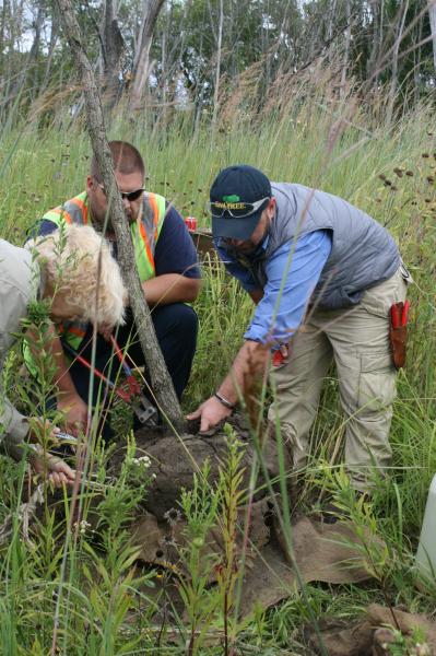
City: Chicago Country / US State / US Territory: Illinois Type of Solution: Streets and Parking Lots Climate Impact: Extreme Temperatures and Urban Heat Island Effect; Air Quality; Extreme Precipitation and Flooding; Invasive Species and Pests Social Value Created: Public Education and Awareness; Community Engagement
The Chicago Regional Trees Initiative is working to increase the tree canopy in the city area. Increasing the tree canopy will help to mitigate extreme temperatures and the urban heat island (UHI) effect, as well as to improve stormwater management to prevent flooding during heavy precipitation events.
Additionally, pest resistant species are being selected to reduce vulnerability to invasive species, such as the Emerald Ash Borer. The city has lost 13 million ash trees already from the Emerald Ash Borer. Members of the initiative help to teach communities how to plan and care for trees, increasing community education and engaging community members.
Further, the initiative is working on incorporating vulnerability into its plans for tree plantings. The Urban Forestry Climate Change Response Framework vulnerability assessment is referenced by the initiative. The framework examines social factors of adaptive capacity, examining aspects such as the value of trees to residents, volunteer base size, and presence of incentives to increase public participation and interest. This framework also recommends a community vulnerability workshop to assist in evaluating vulnerability, educating community members and engaging them in the project.
Fig: Chicago Regional Trees Initiative members teaching residents how to properly plant and care for trees
Sources:
Brandt, L.; Scott, L.; Derby Lewis, A.; Darling, L.; Fahey R. 2016. Lessons learned from the
Urban Forestry Climate Change Response Framework. Houghton, MI: Northern Institute of Applied Climate Science. 36 pp.
U.S. Climate Resilience Toolkit. (n.d.). Fortifying Chicago’s urban forest. Retrieved from https://toolkit.climate.gov/case-studies/fortifying-chicagos-urban-forest.
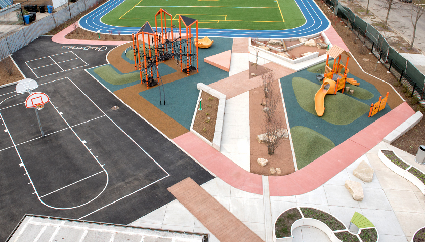
City: Chicago Country / US State / US Territory: Illinois Type of Solution: Streets Climate Impact: Extreme Temperatures and Urban Heat Island Effect; Air Quality; Extreme Precipitation and Flooding Social Value Created: Social Justice and Equity for Vulnerable Communities; Social Cohesion; Public Health and Safety; Active Living; Food Security and Nutrition; Public Spaces and Playspaces
The Space to Grow program was started in 2013 to redevelop asphalt school lots into green infrastructure playgrounds for stormwater management. The playgrounds are designed to manage a 100-year storm lasting 24 hours. Additionally, green infrastructure filers air, improving air quality, and contributes to urban cooling, counteracting extreme temperatures and the urban heat island effect. As of 2016, six playgrounds have been completed and 28 more are planned for completion by 2019.
The playgrounds are also designed to create other social benefits. 90% of students serviced by the playgrounds are from low-income families, improving social resilience of vulnerable communities. Further, the playgrounds are intended to be educational and provide space for community gatherings, increasing social cohesion.
Grissom Elementary School is one school that participated in the Space to Grow program. The school redesigned a schoolyard to include outdoor classroom areas, community vegetable gardens, a jogging track, and green infrastructure for stormwater management. Community vegetable gardens improve access to nutritional food and increase social cohesion, and athletic facilities promote physical activity. Both increase access nutrition and engagement in physical activity helping to counteract childhood obesity, a growing crisis in the United States.
James Wadsworth Elementary School is a STEM school that also participated in the Space to Grow program. An unsafe, deterioration playground and basketball court were redesigned with the help of the students. The new design features a playground, basketball court, turf field, jogging track, two half-court basketball courts, and outdoor classroom areas. There are rain gardens that help manage stormwater runoff, and a decorative water feature that uses stormwater runoff captured from the roof.
City: Boston Country / US State / US Territory: Massachusetts Type of Solution: Streets and Parking Lots Climate Impact: Extreme Temperatures and Urban Heat Island Effect; Air Quality; Extreme Precipitation and Flooding Social Value Created: Water Security and Quality; Public Spaces; Community Engagement; Public Education; Urban Beautification
The Everett Street Pilot demonstration project was completed as part of the Blue Cities Initiative. The project transformed an asphalt parking lot adjacent to the German International School of Boston into a valuable public space. Green infrastructure filters the air, improving air quality, mitigates extreme temperatures and the urban heat island effect, and helps to slow and capture runoff, preventing flooding.
The parking lot incorporated two rain gardens, permeable pavement, and a stormwater tree pit. Trees produce more shade, reducing health risks from the extreme temperatures and improving resident comfort. The landscape is also more aesthetically appealing, contributing to urban beautification, and provides more greenspace for the community to access.
The Charles River Watershed Association (CRWA) coordinated student and community member volunteers to help with landscaping and planting trees for the project, engaging community members and educating them on the connection between green infrastructure, stormwater management, and water quality.