Miami, Florida: Wagner Creek Restoration

City: Miami
Country / US State / US Territory: Florida
Type of Solution: Habitat Restoration
Climate Impact: Seal level rise; Hurricanes and Storm Surge; Extreme Precipitation and Flooding
Social Value Created: Public Education; Community Engagement; Community Wellbeing and Quality of Life; Urban Beautification
Cost: $18.4 million
Funding Source: Public Space Challenge grant

The Nature Conservancy (TNC) partnered with Greater Miami and the Beaches on a project to revitalize Wagner Creek. Over the years, Wagner Creek has been a site of illegal dumping, leaking pipe systems, and stormwater runoff from nearby auto-repair shops, making it one of the most polluted water bodies in Florida. The project will use green infrastructure improve stormwater management in response to flooding from heavy precipitation events and storm surge, as well as to remove pollutants and improve water quality.

Green infrastructure also provides shade, helping to cool the urban environment and mitigate extreme temperatures and the urban heat island effect. Additionally, the project aims to improve community well-being and contribute to urban beautification.

During the design phase of the project, TNC held a public visioning workshop that engaged stakeholders with various backgrounds. Stakeholders identified different services the project could provide and were given stickers to prioritize these services, such as larger/smaller parking lots, parks, tree plantings, and improve water quality for recreation. Then, the University of Miami Landscape Architecture department assisted with developing designs that could be implemented, incorporating climate change projections and other datasets, contributing to the advancement of education. A number of parks are planned as part of the project, and these parks will serve an estimated 100,000 people that live and work in the area.
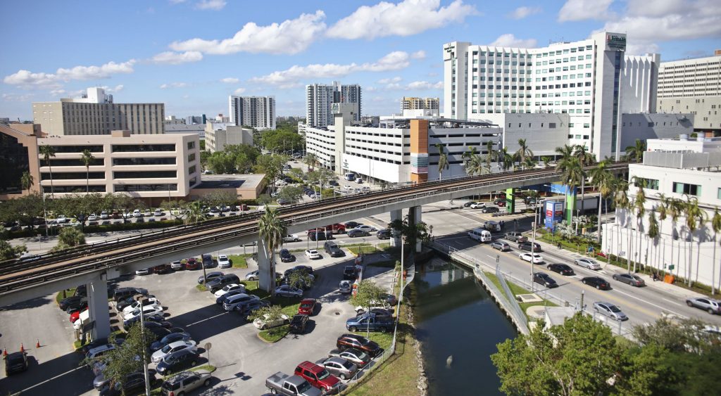
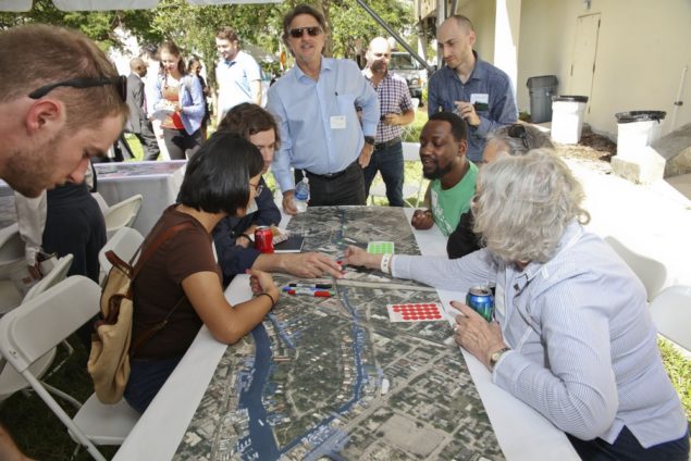
Fig: Wagner Creek (Photo retrieved from https://www.nature.org/ourinitiatives/regions/northamerica/unitedstates/florida/explore/florida-wagner-creek-restoration.xml)

Fig: Residents prioritizing services during vision workshop (Photo retrieved from https://communitynewspapers.com/brickell/the-nature-conservancy-launches-effort-to-revitalize-the-banks-of-wagner-creek/)

Sources:

Heffernan, J. (November 25, 2017). The Nature Conservancy launches effort to revitalize the banks of Wagner Creek. Miami’s Community Newspapers. Retrieved from https://communitynewspapers.com/brickell/the-nature-conservancy-launches-effort-to-revitalize-the-banks-of-wagner-creek/.

The Nature Conservancy. (November 8, 2017). The Nature Conservancy to revitalize Wagner Creek. Retrieved from https://www.nature.org/ourinitiatives/regions/northamerica/unitedstates/florida/newsroom/florida-revitalizing-miamis-wagner-creek.xml.

The Nature Conservancy. (n.d.). The greening of Wagner Creek. Retrieved from https://www.nature.org/ourinitiatives/regions/northamerica/unitedstates/florida/explore/florida-wagner-creek-restoration.xml.

*Note: This case was documented from an interview with a city practitioner.

Miami, Florida: Citizen Science Sampling Campaign for King Tides

City: Miami
Country / US State / US Territory: Florida
Type of Solution: Awareness Campaign
Climate Impact: Sea Level Rise
Social Value Created: Public Education; Community Engagement; Social Justice and Equity for Vulnerable Communities; Public Health and Safety

During King Tides, groundwater rises and seeps up into low-lying communities. While currently these events only occur a few times a year, they could occur as frequently as 30 to 40 times a year by 2030. Florida International University (FIU) is leading a volunteer program to help map and collect data on these King Tides, helping to inform adaptation solutions.

Local community members volunteer for a few hours during these King Tides to take and record measurements in a phone application, recording the depth, length, and location of the King Tide. This method improve community awareness and helps to engage community members in solution development.

One of these sampling events, Sea Level Solutions Day, occurred on November 4, 2017. Over 75 citizen scientists volunteered, assisting in sampling in six different Miami neighborhoods. Samples were taken for traces of fecal coliform and other indicators of contamination.

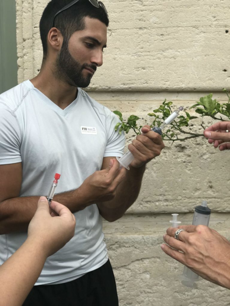
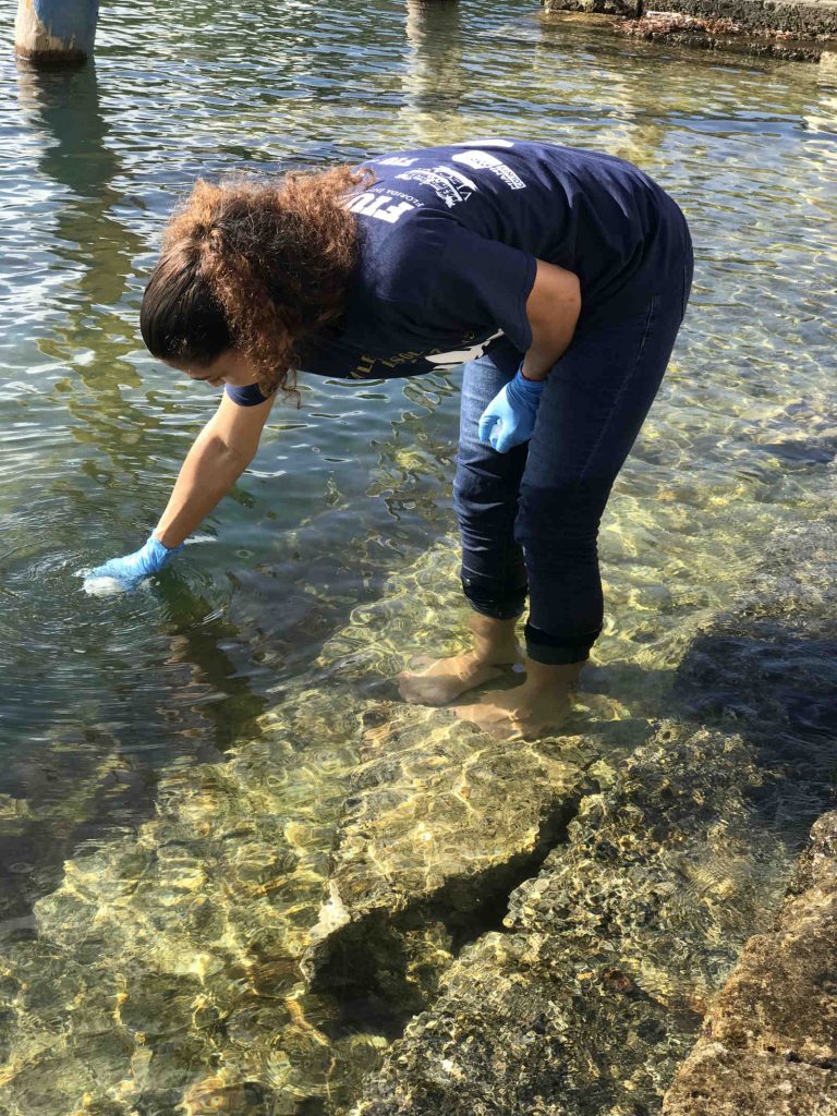
Fig: Citizen scientist, Lesly Abreu, collecting flood water samples at Vizcaya Museum and Gardens for Sea Level Solutions (Photo retrieved from https://slsc.fiu.edu/solutions/outreach-and-engagement/citizen-science/sea-level-solutions-day/index.html)

Fig: Citizen scientist, Bryan Palacio, testing flood water samples for bacterial content (Photo retrieved from https://slsc.fiu.edu/solutions/outreach-and-engagement/citizen-science/sea-level-solutions-day/index.html)

Sources

Florida International University Sea Level Solutions Center. (n.d.). Citizen Science. Retrieved from https://slsc.fiu.edu/solutions/outreach-and-engagement/citizen-science/index.html.

Florida International University Sea Level Solutions Center. (n.d.). Sea Level Solutions Day. Retrieved from https://slsc.fiu.edu/solutions/outreach-and-engagement/citizen-science/sea-level-solutions-day/index.html.

New Delhi Times Bureau. (December 9, 2017). Miami citizens become scientists to study rising seas. Retrieved from https://www.newdelhitimes.com/miami-citizens-become-scientists-to-study-rising-seas/.

*Note: This case was documented from an interview with a city practitioner.

San Francisco, California: Public Utilities Commission Green Infrastructure Projects

City: San Francisco
Country / US State / US Territory: California
Type of Solution: Green Infrastructure, Streets
Climate Impact: N/A
Social Value Created: Diverse Transportation; Public Health and Safety; Active Living and Recreation; Public Education; Urban Beautification; Social Cohesion; Public Spaces

The San Francisco Public Utilities Commission (SFPUC) is implementing various green infrastructure projects to improve stormwater management as part of its Urban Watershed Assessment. San Francisco has a combined sewer system, posing an increased risk to public health during heavy precipitation events if sewers overflow.

In addition to stormwater management, social value has been co-created by many of the projects. Many projects improve walkability and bikeability of streets, traffic calming and reduced congestion, and provide more spaces for community gatherings, which contributes to urban beautification and increased social cohesion.

Thus far, SFPUC has completed six green infrastructure projects. Eight additional projects are currently underway. These projects were identified in a participatory planning workshop held by SFPUC in 2007.

Cesar Chavez Streetscape Improvement is a demonstration project for the Better Streets Plan that was completed in the Mission neighborhood. 18 rain gardens were constructed along a half mile portion of a street. Trees and drought-tolerant landscaping were also planted to help manage stormwater. Additionally, traffic-calming bulb-outs were constructed and a bike lane was created to improve pedestrian and bicycle safe.

Newcomb Avenue Green Street is another green infrastructure project that has been completed to improve stormwater management. This project focused on creation of community gathering spaces and urban beautification in addition to traffic calming improvements. Additionally, the project helped to improve property values for residents.

Sources:
City and County of San Francisco Planning Department. (n.d.). Newcomb Avenue model block streetscape improvement project. Retrieved from http://sf-planning.org/newcomb-avenue-model-block-streetscape-improvement-project.

The Adaptation Clearinghouse. (2016). San Francisco Public Utilities Commission green infrastructure projects. Retrieved from http://www.adaptationclearinghouse.org/resources/san-francisco-public-utilities-commission-green-infrastructure-projects.html.

San Diego, California: Water Conservation Home Makeover at Chollas Creek

City: San Diego
Country / US State / US Territory: California
Type of Solution: Buildings and Housing
Climate Impact: Drought
Social Value Created: Community Engagement; Public Education; Public Health and Safety; Food Security and Nutrition; Water Security and Quality; Social Justice and Equity for Vulnerable Communities
Cost: $524,000

The Water Conservation Home Markover is a pilot project that helped neighborhoods facing issues with water and food security, many of which were Spanish speaking residents, with water conservation renovations. These renovations helped to reduce water consumption, as well as improve stormwater management. Homes were retrofitted with gray water systems, low-flow fixtures, and sink aerators. Additionally, rail barrels were installed and residents were provided with a pallet of drought tolerant landscaping plants and a low-water fruit tree, providing additional access to fresh, healthy foods.

The project also support community education. Participating residents are quarterly sent reports detailing the amount of water saved, energy saved, and carbon sequestration resulting from the project. Additionally, local schools feature the project in classroom lessons and take field trips to see the projects. An outdoor climate action center was also donated to the Millennial Tech Middle School by local landscape architects, providing a space for students to learn about drought tolerant landscaping.

Sources:
Atlas. (n.d.). Water Conservation Home Makeover at Chollas Creek. Retrieved from https://www.the-atlas.com/project?id=350.

San Diego, California: Environmental Health Coalition

City: San Diego
Country / US State / US Territory: California
Type of Solution: Awareness Campaign / Community Outreach and Education Program
Climate Impact: Extreme Temperatures and Urban Heat Island Effect; Air Quality; Extreme Precipitation and Flooding
Social Value Created: Community Engagement; Public Education; Public Health and Safety; Equitable Services and Access; Social Justice and Equity for Vulnerable Communities

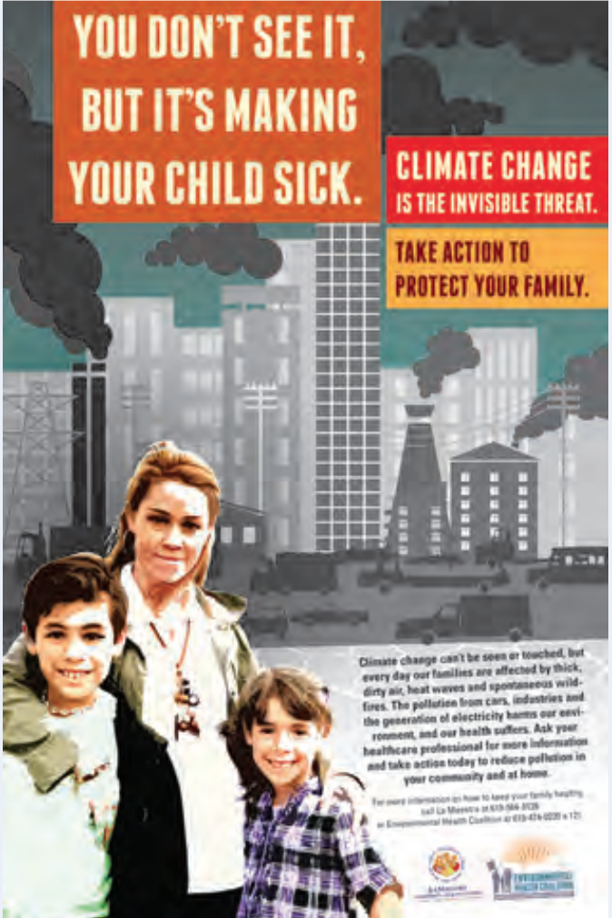
The Environmental Health Coalition is a community-based organization focusing on bringing climate justice to low-income communities of immigrants and refugees in San Diego, California. The program has developed bilingual education materials, such as brochures, posters, and promotoras, about air pollution, climate change, and climate impacts. These materials focus on solutions community members can implement that will also save money.

EHC has also facilitated the development of a climate action plan for these communities, focusing on transportation justice, energy justice, good jobs, climate change resilience, and bold goals, state, and local climate laws.

Fig: Example of a sign used to communicate the health risks of climate change

Sources

Rudolph, L. Gould, S., & Berko, J. (2015). Climate change, health and equity: opportunities for action. Public Health Institute, Oakland, CA. Retrieved from http://www.phi.org/uploads/application/files/h7fjouo1i38v3tu427p9s9kcmhs3oxsi7tsg1fovh3yesd5hxu.pdf.

Phoenix, Arizona: Resilience AmeriCorps

City: Phoenix
Country / US State / US Territory: Arizona
Type of Solution: Volunteer / Community Group
Climate Impact: Extreme Temperatures and Urban Heat Island Effect; Air Quality; Extreme Precipitation and Flooding
Social Value Created: Social Justice and Equity for Vulnerable Communities; Community Engagement; Public Education; Diverse Transportation; Public Health and Safety; Urban Beautification; Community Wellbeing and Quality of Life

The City of Phoenix is participating in the national Resilience AmeriCorps program. The local program is called Resilient PHX. Volunteers assist low-income communities with projects to build community capacity. Resilient PHX has already completed a number of projects, such as Grandview Message Boards, Grand Avenue Curb Cut/Rain Garden, and Triangle Tree Planting.

Three message boards were installed in the Grandview Neighborhood to improve communication of climate risks, such as the risks of extreme heat in vulnerable communities, specifically low-income residents, elderly residents, and renters.

Another project was the Grand Avenue Curb Cut/Rain Garden. The curb cut/rain garden improves stormwater management to prevent flooding risks during heavy precipitation events. In addition to improved stormwater management, the project created more greenspace for residents and improved aesthetics, walkability, and shade coverage.

Lastly, the Triangle Tree Planting project was a community outreach program that engaged residents in tree planting and taught residents tree maintenance in an effort to mitigate extreme heat and the heat island effect. Trees increase shade coverage, which also contributes the the walkability of the area.

Sources: City of Phoenix. (n.d.). Resilient PHX. Retrieved from https://www.phoenix.gov/volunteer/resilient-phx.

Miami, Florida: Eyes on the Rise Toolkit

City: Miami
Country / US State / US Territory: Florida
Type of Solution: Awareness Campaign / Community Outreach and Education Program
Climate Impact: Seal Level Rise; Hurricanes and Storm Surge; Extreme Precipitation and Flooding
Social Value Created: Public Education; Community Engagement; Social Justice and Equity for Vulnerable Communities

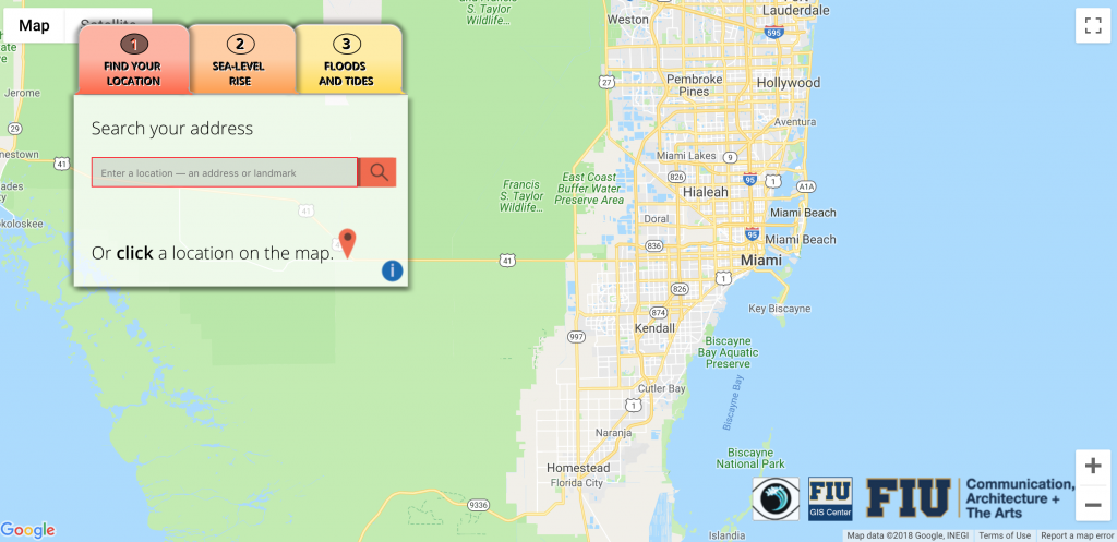
The Eyes on the Rise Toolkit is a Florida International University project that is aimed at informing citizens of South Florida about the potential impact of sea level rise in their neighborhoods. The Toolkit is an application that allows citizens to enter their location to see a sea level rise simulation and show elevation data.

Citizens are also provided with data and resources, including flooding reports, flood insurance data, tide measurement, elevation, and groundwater levels. Citizens can also use the application to report a flood. The Toolkit is aimed to help improve community knowledge systems, increasing community awareness and engage vulnerable communities in sea level rise adaptation.

Fig: Eyes on the Rise Toolkit application interface (Photo retrieved from http://citizeneyes.org/app/)

Sources: Eyes on the Rise. (n.d.). About the app. Retrieved from http://www.eyesontherise.org/about-the-app/.

*Note: This case was documented from an interview with a city practitioner.
Chicago, Illinois: Pilsen Sustainable Streets

City: Chicago
Country / US State / US Territory: Illinois
Type of Solution: Streets and Parking Lots
Climate Impact: Extreme Temperatures and Urban Heat Island Effect; Extreme Precipitation and Flooding
Social Value Created: Public Health and Safety; Water Security and Quality; Diverse Transportation; Public Education; Public Education and Awareness; Community Wellbeing and Quality of Life

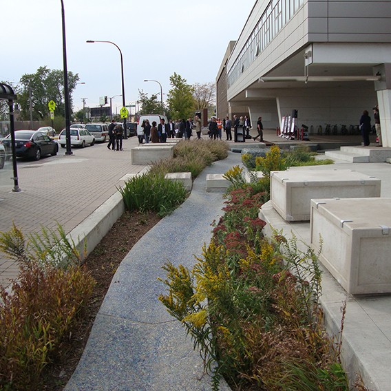
The Chicago Department of Transportation (CDOT) implemented the Pilsen Sustainable Streets project in 2012. The project uses permeable pavement and green infrastructure, such as bioswales and rain gardens, manage projected increases in heavy precipitation and flooding. Stormwater filtration helps to remove pollutants, improving water quality. The City of Chicago has a combined sewer system, making the ability to effectively manage stormwater essential to protecting public health.

Additionally, green infrastructure contributes to improved air quality and urban cooling, counteracting extreme temperatures and the urban heat island effect. The area of vegetative landscapes and tree canopy were increased by 131%, providing more shaded areas, lowering the temperature, and increasing stormwater filtration. Increased shade and lowered temperatures improves comfort of community members and improves public health.

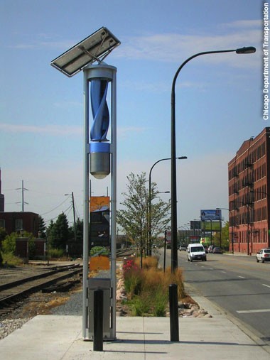
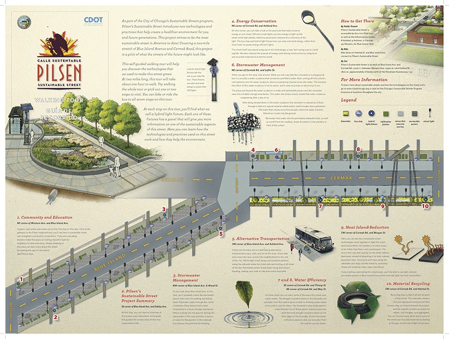
The project also resulted in creation of social value. A pedestrian refuge island was installed in Cermak Road and curb-corner extensions were created to improve pedestrian safety. Community outreach and education is another key feature of the project. Educational kiosks, a walking tour brochure, and a guidebook are available for community members to learn about the sustainable best practices employed by the project. These kiosks are powered by solar and wind energy.

Fig: Example of green infrastructure used in Pilsen Sustainable Streets project (Retrieved from https://www.wightco.com/work/pilsen-sustainable-street/)

Fig: LED light pole and educational kiosk (Retrieved from https://iitbuildingscience.wordpress.com/2013/09/09/greenest-sustainable-street-in-america/)

Fig: Walking tour educational brochure (Retrieved from https://www.wightco.com/projects/cermak-road-streetscape)

Sources: The Adaptation Clearinghouse. (May 13, 2016). Pilsen Sustainable Streets (Chicago, Illinois Department of Transportation. Retrieved from http://www.adaptationclearinghouse.org/resources/pilsen-sustainable-streets-chicago-illinois-department-of-transporation.html

The City of Chicago. (October 9, 2012). Transportation: City Unveils “Greenest Street in America” in Pilsen Neighborhood. Retrieved from https://www.cityofchicago.org/city/en/depts/cdot/provdrs/conservation_outreachgreenprograms/news/2012/oct/cdot_opens_the_pilsensustainablestreet.html.

Rotenberk, L. (October 8, 2012). The greenest mile: Chicago pushes the limits on sustainable streets. Grist Magazine. Retrieved from https://grist.org/cities/the-greenest-mile-chicago-pushes-the-limits-on-sustainable-streets/

Boston, Massachusetts: Everett Street Pilot Demonstration Project

City: Boston
Country / US State / US Territory: Massachusetts
Type of Solution: Streets and Parking Lots
Climate Impact: Extreme Temperatures and Urban Heat Island Effect; Air Quality; Extreme Precipitation and Flooding
Social Value Created: Water Security and Quality; Public Spaces; Community Engagement; Public Education; Urban Beautification

The Everett Street Pilot demonstration project was completed as part of the Blue Cities Initiative. The project transformed an asphalt parking lot adjacent to the German International School of Boston into a valuable public space. Green infrastructure filters the air, improving air quality, mitigates extreme temperatures and the urban heat island effect, and helps to slow and capture runoff, preventing flooding.

The parking lot incorporated two rain gardens, permeable pavement, and a stormwater tree pit. Trees produce more shade, reducing health risks from the extreme temperatures and improving resident comfort. The landscape is also more aesthetically appealing, contributing to urban beautification, and provides more greenspace for the community to access.

The Charles River Watershed Association (CRWA) coordinated student and community member volunteers to help with landscaping and planting trees for the project, engaging community members and educating them on the connection between green infrastructure, stormwater management, and water quality.

Fig: Green infrastructure along Everett Street. Source: https://www.crwa.org/blue-cities/demonstration-projects/everett-street-pilot