City: Valdivia Country / US State / US Territory: Chile Type of Solution: Climate Impact: Extreme Precipitation and Flooding Social Value Created: Public Spaces; Public Education and Awareness; Social Justice and Equity; Public Health and Safety
In Valdivia, wetland areas have been an issue for residents. Many low-income communities are located adjacent to wetland areas, which are generally sites for illicit activities and dumping. Additionally, many residents do not have accessible areas of greenspace.
Valdivia is undertaking projects to convert these wetland areas into parks that are more accessible and are better illuminated, which help to protect a valuable stormwater management asset. Converting these areas mitigates illicit activities and illegal dumping in these vulnerable communities.
One example of a park developed in a wetland area is Parque Urbano Catrico. The park is surrounded by low-income communities, and these communities are the first to have problems during extreme events. Thus, these communities are the first people engaged in the process. In the Parque Urban Catrico project, many residents are requesting grey infrastructure. However, the architects designing the process are working on educating residents on the benefits of green infrastructure, helping to improve public education and awareness.
City: San Francisco Country / US State / US Territory: California Type of Solution: Green Infrastructure, Streets Climate Impact: N/A Social Value Created: Diverse Transportation; Public Health and Safety; Active Living and Recreation; Public Education; Urban Beautification; Social Cohesion; Public Spaces
The San Francisco Public Utilities Commission (SFPUC) is implementing various green infrastructure projects to improve stormwater management as part of its Urban Watershed Assessment. San Francisco has a combined sewer system, posing an increased risk to public health during heavy precipitation events if sewers overflow.
In addition to stormwater management, social value has been co-created by many of the projects. Many projects improve walkability and bikeability of streets, traffic calming and reduced congestion, and provide more spaces for community gatherings, which contributes to urban beautification and increased social cohesion.
Thus far, SFPUC has completed six green infrastructure projects. Eight additional projects are currently underway. These projects were identified in a participatory planning workshop held by SFPUC in 2007.
Cesar Chavez Streetscape Improvement is a demonstration project for the Better Streets Plan that was completed in the Mission neighborhood. 18 rain gardens were constructed along a half mile portion of a street. Trees and drought-tolerant landscaping were also planted to help manage stormwater. Additionally, traffic-calming bulb-outs were constructed and a bike lane was created to improve pedestrian and bicycle safe.
Newcomb Avenue Green Street is another green infrastructure project that has been completed to improve stormwater management. This project focused on creation of community gathering spaces and urban beautification in addition to traffic calming improvements. Additionally, the project helped to improve property values for residents.
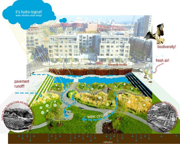
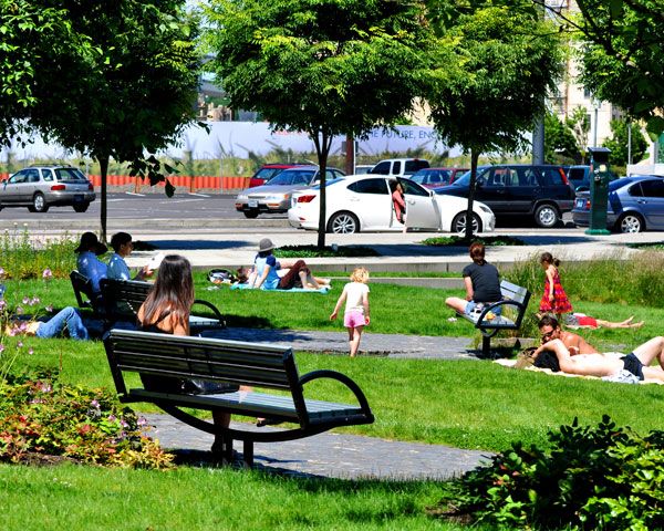
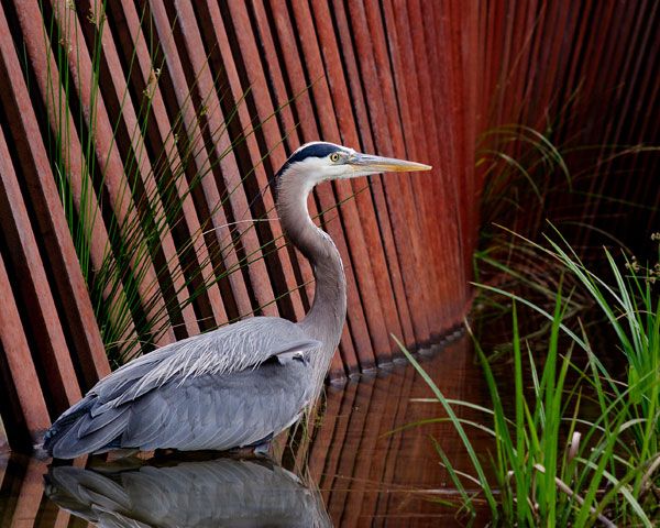
City: Portland Country / US State / US Territory: Portland Type of Solution: N/A Climate Impact: Extreme Precipitation and Flooding, Air Quality Social Value Created: Public Spaces; recreation, arts and culture; active living; transportation diversity
Tanner Springs Park is a park located in Portland, Oregon. The park mimics a wetland that captures and filters stormwater, reducing flooding during extreme precipitation events and improving water quality. Additionally, the wetland helps to improve air quality. The wetland design helps to promote biodiversity, as well.
The project also provides the community with accessible public space and has a number of social benefits for the community. Tanner Springs Park features a boardwalk and art installation on the east side of the park, and there is a recreational path running through the central area of the park. The art installation contributes to the community’s arts and culture. Recreational trails contribute to active lifestyles, as well as improve walkability and bikeability that contributes to diversity of transportation.
Community members were also engaged in the design process through surveys and planning charrettes in order to provide socially valuable features for that particular community.
City: Boston Country / US State / US Territory: Massachusetts Type of Solution: Streets and Parking Lots Climate Impact: Extreme Temperatures and Urban Heat Island Effect; Air Quality; Extreme Precipitation and Flooding Social Value Created: Water Security and Quality; Public Spaces; Community Engagement; Public Education; Urban Beautification
The Everett Street Pilot demonstration project was completed as part of the Blue Cities Initiative. The project transformed an asphalt parking lot adjacent to the German International School of Boston into a valuable public space. Green infrastructure filters the air, improving air quality, mitigates extreme temperatures and the urban heat island effect, and helps to slow and capture runoff, preventing flooding.
The parking lot incorporated two rain gardens, permeable pavement, and a stormwater tree pit. Trees produce more shade, reducing health risks from the extreme temperatures and improving resident comfort. The landscape is also more aesthetically appealing, contributing to urban beautification, and provides more greenspace for the community to access.
The Charles River Watershed Association (CRWA) coordinated student and community member volunteers to help with landscaping and planting trees for the project, engaging community members and educating them on the connection between green infrastructure, stormwater management, and water quality.
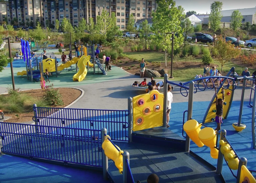
City: Atlanta Country / US State / US Territory: Georgia Type of Solution: Vacant Commercial Properties and Lots Climate Impact: Extreme Temperatures and Urban Heat Island Effect; Air Quality; Extreme Precipitation and Flooding Social Value Created: Social Cohesion; Quality of Life; Public Health and Safety; Diverse Transportation; Historic Preservation; Public Spaces; Active Living and Playspaces
A former industrial and commercial property has been revitalized to become a 17-acre urban park, Historic Fourth Ward Park. The park is adjacent to the Atlanta BeltLine project, a rails to trails project that is restoring 22 miles of abandoned railway beds into recreational trails and a streetcar line. The $ project was completed in 2011, and the use of green infrastructure opposed to traditional gray infrastructure drainage system the city is estimated to have saved $15 million.
The park is located in an area that historically has experienced flooding and sewer overflows during storms. The green infrastructure system, consisting of bioretention, underground cisterns, and pervious surfaces, will help to improve stormwater management, with the capacity to capture runoff for a 100-year storm. Preventing sewer overflows helps to counteract the spread of waterborne diseases, contributing to public health.
One of the park’s features is a two-acre stormwater detention pond, Clear Creek Basin, which has already helped to reduce flooding in the surrounding neighborhoods. The Basin not only reduces flooding, but it also acts as a water reserve providing 425 gallons per minute even during a drought. The Basin was designed to use plantings and landscaping strategies used in wetlands.
Additionally, the greenspace improves air quality and contributes to urban cooling, mitigating extreme temperatures and the urban heat island effect. Trees and play structures increase shade, improving the comfort of community members and their overall quality of life.
In addition to improved stormwater management, a previously underutilized space is now creating social value for the community. The park provides community gathering space, contributing to social cohesion. In the park there is a playground and splash pad for children to play, which helps to keep children physically active, improving children’s health. The park also provides recreational paths for biking and walking, contributing to diversity of transportation.
Sources:
The Environmental Protection Agency. (2017). Green infrastructure in parks: a guide to collaboration, funding, and community engagement. Retrieved from http://www.adaptationclearinghouse.org/resources/green-infrastructure-in-parks-a-guide-to-collaboration-funding-and-community-engagement.html