New York, New York: Gowanus Canal Sponge Park

City: New York
Country / US State / US Territory: New York
Type of Solution: Canal
Climate Impact: Extreme Precipitation and Flooding
Social Value Created: Water Security and Quality; Public Health and Safety; Public Space; Active Living and Recreation
Cost: $1.5 million
Funding Source: Public health; access to public space; water quality; recreation; redevelopment and brownfields

In 2010, the canal was named an EPA Superfund site, and the Sponge Park project emerged as a solution that would not only remediate the site and prevent future pollution but also improve access to a number of public spaces. Currently, the NYC area does not meet federal water quality standards for swimming, fishing, and wildlife habitats due to its inability to prevent pollution, particularly sewer overflows during heavy rain events. The water quality poses a health hazard to community members.

Gowanus Canal Sponge Park was built to manage stormwater, helping to slow, absorb, and filter polluted surface water runoff. Street runoff is captured and stored in underground tanks, which are then filtered by artificial wetlands and then released into the canal. The park is estimated to capture and treat 1 million gallons of storm water annually. This project will help to improve water quality in the surrounding waterways for recreational use and protect wildlife habitat.

The New York City Department of Environmental Protection (DEP) and Department of Design and Construction also built 70 curbside rain gardens in South Brooklyn. These additional rain gardens can manage 133,000 gallons of stormwater runoff and will capture an estimated 6 million gallons of stormwater runoff annually. Long-term, the project aims to create 11.4 acres of revitalized canal space, 7.9 acres of public spaces and 3.5 acres of remediated wetland basins.

Fig: Gowanus Canal Sponge Park (Photo retrieved from https://www.the-atlas.com/project?id=249#)

Sources

Atlas. (n.d.). Gowanus Canal Sponge Park. Retrieved from https://www.the-atlas.com/project?id=249#.

San Francisco, California: Baylands Restoration

City: San Francisco
Country / US State / US Territory: California
Type of Solution: Habitat Restoration
Climate Impact: Seal Level Rise; Hurricanes and Storm Surge; Extreme Precipitation and Flooding
Social Value Created: Community Engagement; Employment Opportunities; Water Security and Quality; Property Values; Active Living and Recreation; Urban Beautification

San Francisco has set a goal to restore 100,000 acres of the bay’s tidal marshes. A 2015 study projects that most of the existing marshes will be damaged or destroyed by 2100. The City has identified restoration of marshes as a strategy for managing sea level rise, as it provides the community with other socially value co-benefits unlike other sea level rise solutions.

Through restoration initiatives and innovative strategies, marshes can be restored and enhanced to prepare for sea level rise and coastal flooding. Additionally, the marshes help to filter pollutants out of runoff to improve water quality, and they provide habitat for many at-risk species and species critical to the economy, such as Dungeness crab and salmon. Further, restoration projects help to control coastal erosion of water front properties.

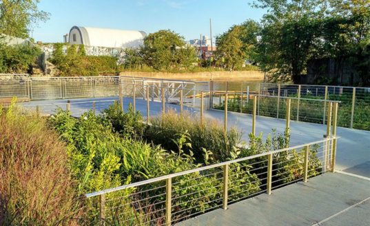
Sonoma Land Trust acquired 1,000 acres of tidal marshes in the Sears Point Wetland along the northern shore of San Francisco Bay. For the project, 285 feet of an existing levee was breached to restore previous marsh land, creating a “habitat” levee using marsh mounds, or raise “islands”. 500 marsh mounds were constructed, each of which are 6 feet tall and 50-75 feet wide, using reclaimed sediment. These mounds support marsh accretion and provide cover for nesting birds from the rising tides and waves during storms. The “habitat” levee both protects the adjacent a nearby highway and railroad and provides additional wildlife habitat.

The project also includes the development of a 2.5 mile section of the Bay Trail, a recreational trail running through the marshes. This addition will provide users with views of Mt. Tamalpais, Mt. Diablo, and the San Francisco skyline, as well as include new benches, interpretive signs, and parking.

South Bay Salt Pond Restoration Project is another project underway, seeking to restore 15,100 acres of former commercial salt ponds to functional tidal marshes. The Project is will manage coastal flooding, as well as improve wildlife habitat and increase public recreational access. A 400 foot berm will be constructed to help control flooding. 16 islands, each 15,000 square feet, will also be constructed. Levees will also be lowered and breeched to restore 130 acres of tidal pools.

In addition to flooding control measures, public recreational trails will be realigned and resurfaced to improve public access, and two overlooks and four interpretive panels will be installed.

Environmental Protection Agency. (n.d.). South Bay Salt Pond Tidal Marsh Restoration at Pond A17 Project. Retrieved from https://www.epa.gov/sfbay-delta/south-bay-salt-pond-tidal-marsh-restoration-pond-a17-project.

Small-Lorenz, S. L., Stein, B. A., Schrass, K., Holstein, D. N., & Mehta, A. V. (2016). Natural defenses in action: harnessing nature to protect our communities. National Wildlife Foundation, Washington, D.C. Retrieved from https://www.nwf.org/~/media/PDFs/Global-Warming/Reports/NWF_Natural-Defenses-in-Action_Report.pdf.

Sonoma Land Trust. (June 6, 2014). Sonoma Land Trust and Ducks Unlimited kick off construction of Sears Point 960-Acre Wetland Restoration Project on San Pablo Bay. Retrieved from https://www.sonomalandtrust.org/news_room/press_releases/1406-sears-point.html.

Sonoma Land Trust. (n.d.). Seas Point Wetland Restoration Project groundbreaking FAQs. Retrieved from https://sonomalandtrust.org/news-room/jenner-information-kit/faq/.

South Bay Salt Pond Restoration Project. (n.d.). Project description. Retrieved from http://www.southbayrestoration.org/Project_Description.html.

Wood, J., Pitkin, M., Meisler, J., DiPietro, D., Graffis, A., & Fris, R. (January 17, 2018). Saving tidal marshes in the San Francisco Bay. U.S. Climate Resilience Toolkit. Retrieved from https://toolkit.climate.gov/case-studies/saving-tidal-marshes-san-francisco-bay.

San Diego, California: Water Conservation Home Makeover at Chollas Creek

City: San Diego
Country / US State / US Territory: California
Type of Solution: Buildings and Housing
Climate Impact: Drought
Social Value Created: Community Engagement; Public Education; Public Health and Safety; Food Security and Nutrition; Water Security and Quality; Social Justice and Equity for Vulnerable Communities
Cost: $524,000

The Water Conservation Home Markover is a pilot project that helped neighborhoods facing issues with water and food security, many of which were Spanish speaking residents, with water conservation renovations. These renovations helped to reduce water consumption, as well as improve stormwater management. Homes were retrofitted with gray water systems, low-flow fixtures, and sink aerators. Additionally, rail barrels were installed and residents were provided with a pallet of drought tolerant landscaping plants and a low-water fruit tree, providing additional access to fresh, healthy foods.

The project also support community education. Participating residents are quarterly sent reports detailing the amount of water saved, energy saved, and carbon sequestration resulting from the project. Additionally, local schools feature the project in classroom lessons and take field trips to see the projects. An outdoor climate action center was also donated to the Millennial Tech Middle School by local landscape architects, providing a space for students to learn about drought tolerant landscaping.

Sources:
Atlas. (n.d.). Water Conservation Home Makeover at Chollas Creek. Retrieved from https://www.the-atlas.com/project?id=350.

Houston, Texas: Lower Footprint Biofiltration

City: Houston
Country / US State / US Territory: Texas
Type of Solution: Streets and Parking Lots
Climate Impact: Hurricanes and Storm Surge; Extreme Precipitation and Flooding; Air Quality
Social Value Created: Diverse Transportation; Urban Beautification; Public Health and Safety; Water Security and Quality
Cost: $9.6 million
Funding:

Bagby Street, a ten-block corridor in a dense, urban neighborhood underwent a redevelopment project. The project improved stormwater management to reduce flooding risks during hurricanes and severe storms. Green infrastructure systems were used to store and filter runoff, reducing flooding risk and improving water quality. The system has a smaller footprint than typical biofiltration systems, requiring only 1/20th of the space. 33% of stormwater runoff is captured by the system, removing 75% bacteria, 73% phosphorous, 93% oil and grease, 43% nitrogen, and 85% total suspended solids. Trees were also planted to aid with stormwater management, increasing the number of trees by 165%.

Additionally, the project improved traffic congestion and walkability, as well as the overall aesthetic appeal of the road, contributing to diverse transportation, public health and safety, and urban beautification. The smaller footprint design was essential for managing stormwater given the limited space available for green infrastructure. Private development also increased as a result of the project, totaling to $25 million in new development.

Fig: Sidewalk area with rain garden biofiltration system (Photo retrieved from http://www.uta.edu/faculty/nickfang/downloads/UTA_LID_2014/05_Batts_Penland_2014.pdf)

Fig: A portion of the biofiltration system (Photo retrieved from https://www.the-atlas.com/project?id=341#)

Sources: Atlas. (n.d.). Lower footprint biofiltration to increase efficiency in right of way stormwater capture. Retrieved from https://www.the-atlas.com/project?id=341#.

Chicago, Illinois: Pilsen Sustainable Streets

City: Chicago
Country / US State / US Territory: Illinois
Type of Solution: Streets and Parking Lots
Climate Impact: Extreme Temperatures and Urban Heat Island Effect; Extreme Precipitation and Flooding
Social Value Created: Public Health and Safety; Water Security and Quality; Diverse Transportation; Public Education; Public Education and Awareness; Community Wellbeing and Quality of Life

The Chicago Department of Transportation (CDOT) implemented the Pilsen Sustainable Streets project in 2012. The project uses permeable pavement and green infrastructure, such as bioswales and rain gardens, manage projected increases in heavy precipitation and flooding. Stormwater filtration helps to remove pollutants, improving water quality. The City of Chicago has a combined sewer system, making the ability to effectively manage stormwater essential to protecting public health.

Additionally, green infrastructure contributes to improved air quality and urban cooling, counteracting extreme temperatures and the urban heat island effect. The area of vegetative landscapes and tree canopy were increased by 131%, providing more shaded areas, lowering the temperature, and increasing stormwater filtration. Increased shade and lowered temperatures improves comfort of community members and improves public health.

The project also resulted in creation of social value. A pedestrian refuge island was installed in Cermak Road and curb-corner extensions were created to improve pedestrian safety. Community outreach and education is another key feature of the project. Educational kiosks, a walking tour brochure, and a guidebook are available for community members to learn about the sustainable best practices employed by the project. These kiosks are powered by solar and wind energy.

Fig: Example of green infrastructure used in Pilsen Sustainable Streets project (Retrieved from https://www.wightco.com/work/pilsen-sustainable-street/)

Fig: LED light pole and educational kiosk (Retrieved from https://iitbuildingscience.wordpress.com/2013/09/09/greenest-sustainable-street-in-america/)

Fig: Walking tour educational brochure (Retrieved from https://www.wightco.com/projects/cermak-road-streetscape)

Sources: The Adaptation Clearinghouse. (May 13, 2016). Pilsen Sustainable Streets (Chicago, Illinois Department of Transportation. Retrieved from http://www.adaptationclearinghouse.org/resources/pilsen-sustainable-streets-chicago-illinois-department-of-transporation.html

The City of Chicago. (October 9, 2012). Transportation: City Unveils “Greenest Street in America” in Pilsen Neighborhood. Retrieved from https://www.cityofchicago.org/city/en/depts/cdot/provdrs/conservation_outreachgreenprograms/news/2012/oct/cdot_opens_the_pilsensustainablestreet.html.

Rotenberk, L. (October 8, 2012). The greenest mile: Chicago pushes the limits on sustainable streets. Grist Magazine. Retrieved from https://grist.org/cities/the-greenest-mile-chicago-pushes-the-limits-on-sustainable-streets/

Boston, Massachusetts: Everett Street Pilot Demonstration Project

City: Boston
Country / US State / US Territory: Massachusetts
Type of Solution: Streets and Parking Lots
Climate Impact: Extreme Temperatures and Urban Heat Island Effect; Air Quality; Extreme Precipitation and Flooding
Social Value Created: Water Security and Quality; Public Spaces; Community Engagement; Public Education; Urban Beautification

The Everett Street Pilot demonstration project was completed as part of the Blue Cities Initiative. The project transformed an asphalt parking lot adjacent to the German International School of Boston into a valuable public space. Green infrastructure filters the air, improving air quality, mitigates extreme temperatures and the urban heat island effect, and helps to slow and capture runoff, preventing flooding.

The parking lot incorporated two rain gardens, permeable pavement, and a stormwater tree pit. Trees produce more shade, reducing health risks from the extreme temperatures and improving resident comfort. The landscape is also more aesthetically appealing, contributing to urban beautification, and provides more greenspace for the community to access.

The Charles River Watershed Association (CRWA) coordinated student and community member volunteers to help with landscaping and planting trees for the project, engaging community members and educating them on the connection between green infrastructure, stormwater management, and water quality.

Fig: Green infrastructure along Everett Street. Source: https://www.crwa.org/blue-cities/demonstration-projects/everett-street-pilot

Boston, Massachusetts: Architectural College Green Alley Initiative

City: Boston
Country / US State / US Territory: Massachusetts
Type of Solution: Green Infrastructure
Climate Impact: Social Value Created: Education; water security and quality

The Boston Architectural College (BAC) completed a green alley demonstration project on its campus. The green alley uses permeable paving that allows water to infiltrate into the ground, filtering pollutants out of the water and recharging the groundwater, contributing to water security and quality. BAC plans to connect the Green Alley to the geothermal well system on campus to support the campus’ use of renewable energy and achieve the net zero energy goal.

The green alley also serves education purposes, educating faculty, staff, and students, as well as for the general public, on the benefits and design of green infrastructure.

Atlanta, Georgia: BeltLine Project

City: Atlanta
Country / US State / US Territory: Georgia
Type of Solution: Railways
Climate Impact: Extreme Temperatures and Urban Heat Island Effect; Air Quality; Extreme Precipitation and Flooding
Social Value Created: Diverse Transportation; Connectivity; Water Security and Quality; Active Living and Playspaces

Fig: Map of the Atlanta BeltLine (Retrieved from https://beltline.org/about/the-atlanta-beltline-project/atlanta-beltline-overview/)
The Atlanta BeltLine project is a rails to trails project that is converting 22 miles of abandoned railway beds into recreational trails for biking and pedestrians, as well as a streetcar line. The project will restore 700 acres of greenspace and create an additional 1,300 acres of greenspace. The $4.8 billion project begun in 2006 and is expected to be completed in 2030.

Greenspace improves air quality and contributes to urban cooling, counteracting extreme temperatures and the urban heat island effect. Additionally, the green infrastructure slows and captures stormwater during heavy rain events, presenting flooding.

The BeltLine project also creates social value for the community. The BeltLine project increases diversity of transportation and improves connectivity between 45 neighborhoods of varying socioeconomic statuses and ethnicities. The greenspace will also help to filter water, improving water quality. Another unique feature of the BeltLine project is an outdoor public art-exhibit, displaying the work of more than 70 artists over the course of 9 miles of the BeltLine, contributing to the city’s arts and culture.

Fig: Before and after completion of the Eastside Trail portion of the BeltLine (Retrieved from https://beltline.org/places-to-go/eastside-trail/)

Fig: William Massey’s “The Art of Reconciliation” sculpture, an example of art displayed on the BeltLine trail (Retrieved from https://www.wheretraveler.com/atlanta/art-beltline)

Sources: Historic Fourth Ward Park Conservancy. (n.d.). Clear Creek Basin. Retrieved from http://www.h4wpc.org/clear-creek-basin/.

The Adaptation Clearinghouse. (n.d.). Case study of the Atlanta BeltLine – adaptation aspects. Retrieved from http://www.adaptationclearinghouse.org/resources/case-study-of-the-atlanta-beltline-adaptation-aspects.html.

WhereTraveler. (n.d.). Art on the beltline. Retrieved from https://www.wheretraveler.com/atlanta/art-beltline.