US – Northeast

New York, New York: Living Breakwaters

City: New York
Country / US State / US Territory: New York
Type of Solution: Seawalls and Living Shorelines
Climate Impact: Seal Level Rise; Hurricanes and Storm Surge; Extreme Precipitation and Flooding
Social Value Created: Educational and Career Development Opportunities; Active Living and Recreation; Community Engagement; Social Cohesion; Arts and Culture
Cost: $60 million
Funding Source: U.S. Department of Housing and Urban Development Rebuild by Design competition

Living Breakwaters is a project aimed at helping to reduce wave energy, lowering flooding risks during extreme storm events. The project was developed by SCAPE landscape Architecture for the Rebuild Design Competition, a competition held by the U.S. Department of Housing and Urban Development (HUD) to improve coastal resilience in response to Hurricane Sandy.

The Living Breakwaters approach uses structures to restore and enhance marine habitats, as well as improve biodiversity. Structures include reef ridges, reef streets, crenulated crests, and bio-enhancing concrete. This habitat mimics historic oyster reefs, which helps to restore the oyster population.

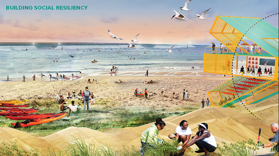
Additionally, the project co-creates social value. The project will help to prevent beach erosion and protect property values. The project also will improves access to the shoreline an recreational opportunities such as boating and fishing.

Also, an on-land Water Hub will be constructed on shore for visitoring groups, recreation, and educational programs. The Harbor School and Billion Oyster Project will create educational opportunities for local schools to learn about ecological stewardship and how they can help to protect Staten Island’s coastline. Implementation of the project also provides educational opportunities for research and skill development through project monitoring.
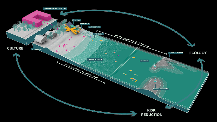
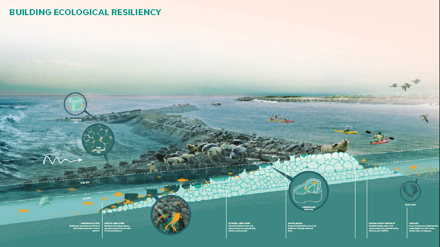
Fig: Graphic showing the project design and connection between risk reduction, ecology, and culture (Image retrieved from http://www.rebuildbydesign.org/our-work/all-proposals/winning-projects/ny-living-breakwaters)

Fig: Graphic showing more specifics about the project’s landscape architecture design (Image retrieved from http://www.rebuildbydesign.org/our-work/all-proposals/winning-projects/ny-living-breakwaters)

Fig: Rendering of the Living Breakwaters project featuring contributions to social resilience (Image retrieved from http://www.rebuildbydesign.org/our-work/all-proposals/winning-projects/ny-living-breakwaters)

Sources

Atlas. (n.d.). Creating protective infrastructure to reduce coastal risk, enhance aquatic habitat, and foster social resilience. Retrieved from https://www.the-atlas.com/project?id=374#.

New York State. (n.d.). Learn more about the Living Breakwaters project. Retrieved from https://stormrecovery.ny.gov/learn-more-about-living-breakwaters-project.

Rebuild by Design. (n.d.). Living Breakwaters. Retrieved from http://www.rebuildbydesign.org/our-work/all-proposals/winning-projects/ny-living-breakwaters.

New York, New York: Gowanus Canal Sponge Park

City: New York
Country / US State / US Territory: New York
Type of Solution: Canal
Climate Impact: Extreme Precipitation and Flooding
Social Value Created: Water Security and Quality; Public Health and Safety; Public Space; Active Living and Recreation
Cost: $1.5 million
Funding Source: Public health; access to public space; water quality; recreation; redevelopment and brownfields

In 2010, the canal was named an EPA Superfund site, and the Sponge Park project emerged as a solution that would not only remediate the site and prevent future pollution but also improve access to a number of public spaces. Currently, the NYC area does not meet federal water quality standards for swimming, fishing, and wildlife habitats due to its inability to prevent pollution, particularly sewer overflows during heavy rain events. The water quality poses a health hazard to community members.

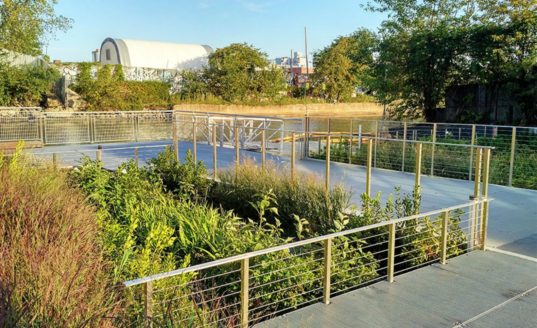
Gowanus Canal Sponge Park was built to manage stormwater, helping to slow, absorb, and filter polluted surface water runoff. Street runoff is captured and stored in underground tanks, which are then filtered by artificial wetlands and then released into the canal. The park is estimated to capture and treat 1 million gallons of storm water annually. This project will help to improve water quality in the surrounding waterways for recreational use and protect wildlife habitat.

The New York City Department of Environmental Protection (DEP) and Department of Design and Construction also built 70 curbside rain gardens in South Brooklyn. These additional rain gardens can manage 133,000 gallons of stormwater runoff and will capture an estimated 6 million gallons of stormwater runoff annually. Long-term, the project aims to create 11.4 acres of revitalized canal space, 7.9 acres of public spaces and 3.5 acres of remediated wetland basins.

Fig: Gowanus Canal Sponge Park (Photo retrieved from https://www.the-atlas.com/project?id=249#)

Sources

Atlas. (n.d.). Gowanus Canal Sponge Park. Retrieved from https://www.the-atlas.com/project?id=249#.

New York, New York: Build it Back Program

City: New York
Country / US State / US Territory: New York
Type of Solution: City Government Program
Climate Impact: Seal Level Rise; Hurricanes and Storm Surge; Extreme Precipitation and Flooding
Social Value Created: Affordable and Safe Housing; Social Justice and Equity for Vulnerable Communities; Public Health and Safety

The Built It Back Program was started after Hurricane Sandy struck in 2012. The Program provided homeowners, landlords, and tenants in low- and middle-income neighborhoods affected by the storm with funds sustainably rebuild homes. The goal of the program is to help vulnerable communities rebuild their homes and be better prepared for future hurricanes.

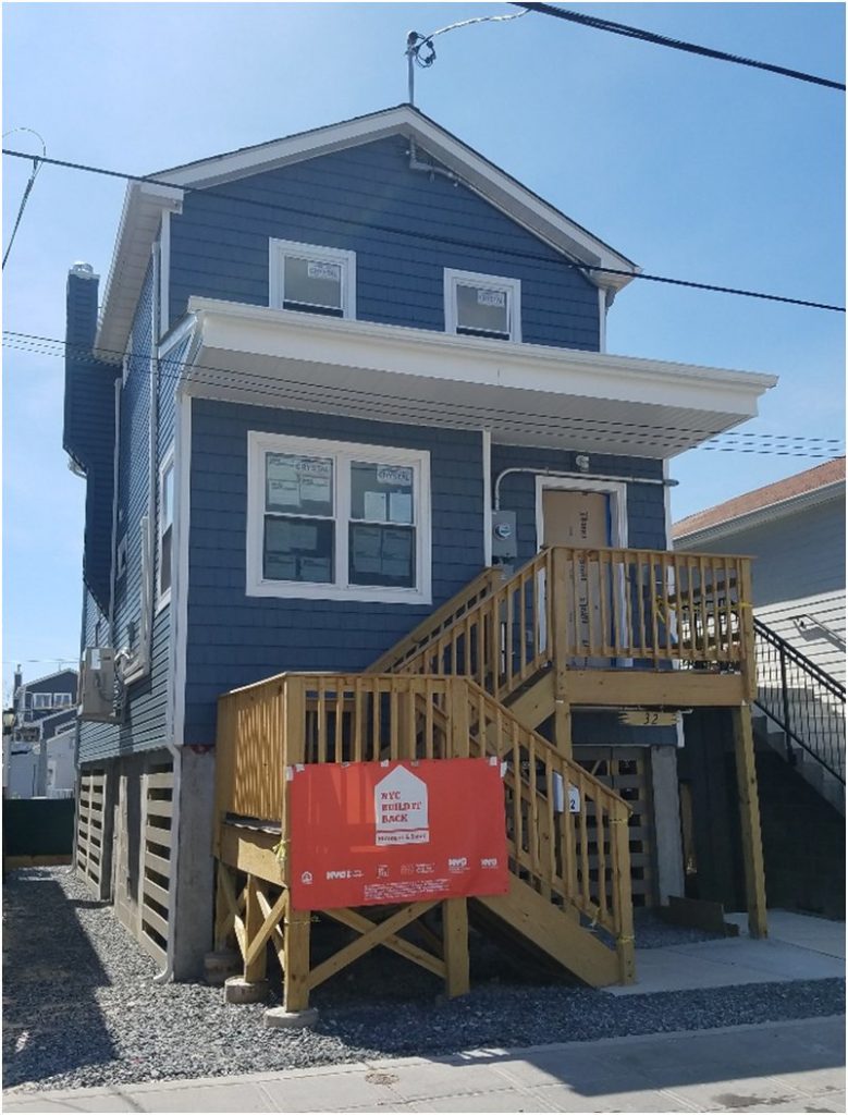
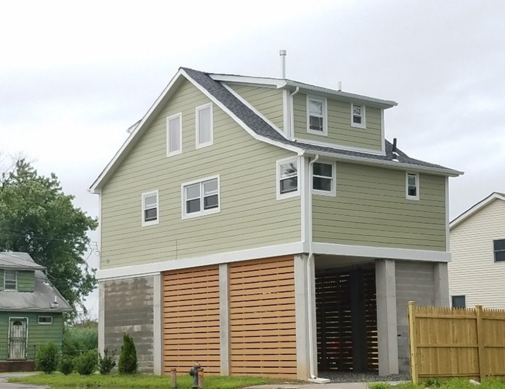
Homes must be rebuilt above Base Flood Elevation level and must be certified by Enterprise Green Communities, a certification for sustainable and energy efficient buildings, to improve communities’ resilience to flooding and Sea Level Rise. In addition to assistance in reconstructing homes, the Program funded legal counseling and temporary housing for residents affected.

The Program received 20,000 applications, and 16,000 completed the initial eligibility review. As of June 2018, the program has helped 12,500 households through reimbursement checks, construction starts, and acquisitions

Fig: A house that has been rebuilt as part of the Build It Back Program, showcasing the elevated design (Photo retrieved from https://twitter.com/NYCBuilditBack)

Fig: A house on Staten Island that has been rebuilt as part of the Build It Back Program (Photo retrieved from https://twitter.com/NYCBuilditBack)

Sources

The City of New York. (2018). NYC Build It Back Stronger and Safer: Welcome to NYC Housing Recovery. Retrieved from http://www.nyc.gov/html/recovery/html/home/home.shtml.

The Adaptation Clearinghouse. (2016). New York City Build It Back Program. Retrieved from http://www.adaptationclearinghouse.org/resources/new-york-city-build-it-back-program.html.

Boston, Massachusetts: Everett Street Pilot Demonstration Project

City: Boston
Country / US State / US Territory: Massachusetts
Type of Solution: Streets and Parking Lots
Climate Impact: Extreme Temperatures and Urban Heat Island Effect; Air Quality; Extreme Precipitation and Flooding
Social Value Created: Water Security and Quality; Public Spaces; Community Engagement; Public Education; Urban Beautification

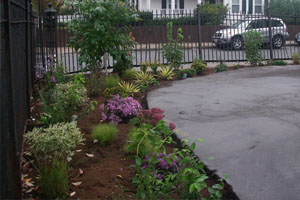
The Everett Street Pilot demonstration project was completed as part of the Blue Cities Initiative. The project transformed an asphalt parking lot adjacent to the German International School of Boston into a valuable public space. Green infrastructure filters the air, improving air quality, mitigates extreme temperatures and the urban heat island effect, and helps to slow and capture runoff, preventing flooding.

The parking lot incorporated two rain gardens, permeable pavement, and a stormwater tree pit. Trees produce more shade, reducing health risks from the extreme temperatures and improving resident comfort. The landscape is also more aesthetically appealing, contributing to urban beautification, and provides more greenspace for the community to access.

The Charles River Watershed Association (CRWA) coordinated student and community member volunteers to help with landscaping and planting trees for the project, engaging community members and educating them on the connection between green infrastructure, stormwater management, and water quality.

Fig: Green infrastructure along Everett Street. Source: https://www.crwa.org/blue-cities/demonstration-projects/everett-street-pilot

Boston, Massachusetts: Architectural College Green Alley Initiative

City: Boston
Country / US State / US Territory: Massachusetts
Type of Solution: Green Infrastructure
Climate Impact: Social Value Created: Education; water security and quality

The Boston Architectural College (BAC) completed a green alley demonstration project on its campus. The green alley uses permeable paving that allows water to infiltrate into the ground, filtering pollutants out of the water and recharging the groundwater, contributing to water security and quality. BAC plans to connect the Green Alley to the geothermal well system on campus to support the campus’ use of renewable energy and achieve the net zero energy goal.

The green alley also serves education purposes, educating faculty, staff, and students, as well as for the general public, on the benefits and design of green infrastructure.