Streets and Parking Lots

Houston, Texas: Lower Footprint Biofiltration

City: Houston
Country / US State / US Territory: Texas
Type of Solution: Streets and Parking Lots
Climate Impact: Hurricanes and Storm Surge; Extreme Precipitation and Flooding; Air Quality
Social Value Created: Diverse Transportation; Urban Beautification; Public Health and Safety; Water Security and Quality
Cost: $9.6 million
Funding:

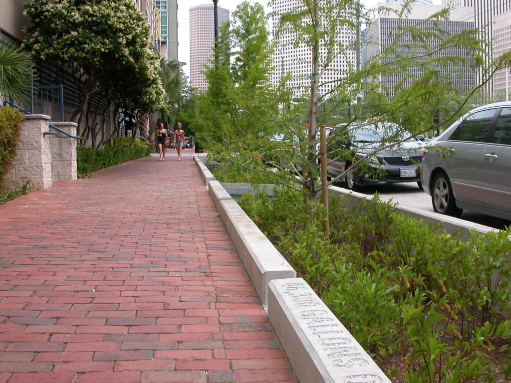
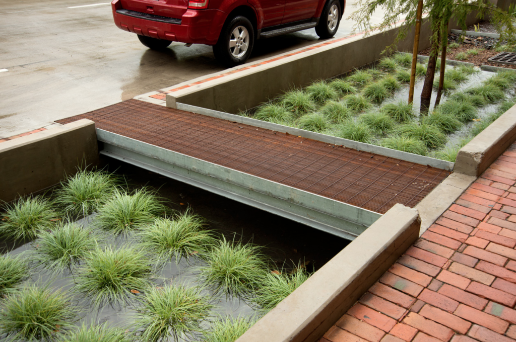
Bagby Street, a ten-block corridor in a dense, urban neighborhood underwent a redevelopment project. The project improved stormwater management to reduce flooding risks during hurricanes and severe storms. Green infrastructure systems were used to store and filter runoff, reducing flooding risk and improving water quality. The system has a smaller footprint than typical biofiltration systems, requiring only 1/20th of the space. 33% of stormwater runoff is captured by the system, removing 75% bacteria, 73% phosphorous, 93% oil and grease, 43% nitrogen, and 85% total suspended solids. Trees were also planted to aid with stormwater management, increasing the number of trees by 165%.

Additionally, the project improved traffic congestion and walkability, as well as the overall aesthetic appeal of the road, contributing to diverse transportation, public health and safety, and urban beautification. The smaller footprint design was essential for managing stormwater given the limited space available for green infrastructure. Private development also increased as a result of the project, totaling to $25 million in new development.

Fig: Sidewalk area with rain garden biofiltration system (Photo retrieved from http://www.uta.edu/faculty/nickfang/downloads/UTA_LID_2014/05_Batts_Penland_2014.pdf)

Fig: A portion of the biofiltration system (Photo retrieved from https://www.the-atlas.com/project?id=341#)

Sources: Atlas. (n.d.). Lower footprint biofiltration to increase efficiency in right of way stormwater capture. Retrieved from https://www.the-atlas.com/project?id=341#.

Chicago, Illinois: Urban Forest Initiative

City: Chicago
Country / US State / US Territory: Illinois
Type of Solution: Streets and Parking Lots
Climate Impact: Extreme Temperatures and Urban Heat Island Effect; Air Quality; Extreme Precipitation and Flooding; Invasive Species and Pests
Social Value Created: Public Education and Awareness; Community Engagement

The Chicago Regional Trees Initiative is working to increase the tree canopy in the city area. Increasing the tree canopy will help to mitigate extreme temperatures and the urban heat island (UHI) effect, as well as to improve stormwater management to prevent flooding during heavy precipitation events.

Additionally, pest resistant species are being selected to reduce vulnerability to invasive species, such as the Emerald Ash Borer. The city has lost 13 million ash trees already from the Emerald Ash Borer. Members of the initiative help to teach communities how to plan and care for trees, increasing community education and engaging community members.

Further, the initiative is working on incorporating vulnerability into its plans for tree plantings. The Urban Forestry Climate Change Response Framework vulnerability assessment is referenced by the initiative. The framework examines social factors of adaptive capacity, examining aspects such as the value of trees to residents, volunteer base size, and presence of incentives to increase public participation and interest. This framework also recommends a community vulnerability workshop to assist in evaluating vulnerability, educating community members and engaging them in the project.

Fig: Chicago Regional Trees Initiative members teaching residents how to properly plant and care for trees

Sources:
Brandt, L.; Scott, L.; Derby Lewis, A.; Darling, L.; Fahey R. 2016. Lessons learned from the
Urban Forestry Climate Change Response Framework. Houghton, MI: Northern Institute of Applied Climate Science. 36 pp.

U.S. Climate Resilience Toolkit. (n.d.). Fortifying Chicago’s urban forest. Retrieved from https://toolkit.climate.gov/case-studies/fortifying-chicagos-urban-forest.

Chicago, Illinois: Pilsen Sustainable Streets

City: Chicago
Country / US State / US Territory: Illinois
Type of Solution: Streets and Parking Lots
Climate Impact: Extreme Temperatures and Urban Heat Island Effect; Extreme Precipitation and Flooding
Social Value Created: Public Health and Safety; Water Security and Quality; Diverse Transportation; Public Education; Public Education and Awareness; Community Wellbeing and Quality of Life

The Chicago Department of Transportation (CDOT) implemented the Pilsen Sustainable Streets project in 2012. The project uses permeable pavement and green infrastructure, such as bioswales and rain gardens, manage projected increases in heavy precipitation and flooding. Stormwater filtration helps to remove pollutants, improving water quality. The City of Chicago has a combined sewer system, making the ability to effectively manage stormwater essential to protecting public health.

Additionally, green infrastructure contributes to improved air quality and urban cooling, counteracting extreme temperatures and the urban heat island effect. The area of vegetative landscapes and tree canopy were increased by 131%, providing more shaded areas, lowering the temperature, and increasing stormwater filtration. Increased shade and lowered temperatures improves comfort of community members and improves public health.

The project also resulted in creation of social value. A pedestrian refuge island was installed in Cermak Road and curb-corner extensions were created to improve pedestrian safety. Community outreach and education is another key feature of the project. Educational kiosks, a walking tour brochure, and a guidebook are available for community members to learn about the sustainable best practices employed by the project. These kiosks are powered by solar and wind energy.

Fig: Example of green infrastructure used in Pilsen Sustainable Streets project (Retrieved from https://www.wightco.com/work/pilsen-sustainable-street/)

Fig: LED light pole and educational kiosk (Retrieved from https://iitbuildingscience.wordpress.com/2013/09/09/greenest-sustainable-street-in-america/)

Fig: Walking tour educational brochure (Retrieved from https://www.wightco.com/projects/cermak-road-streetscape)

Sources: The Adaptation Clearinghouse. (May 13, 2016). Pilsen Sustainable Streets (Chicago, Illinois Department of Transportation. Retrieved from http://www.adaptationclearinghouse.org/resources/pilsen-sustainable-streets-chicago-illinois-department-of-transporation.html

The City of Chicago. (October 9, 2012). Transportation: City Unveils “Greenest Street in America” in Pilsen Neighborhood. Retrieved from https://www.cityofchicago.org/city/en/depts/cdot/provdrs/conservation_outreachgreenprograms/news/2012/oct/cdot_opens_the_pilsensustainablestreet.html.

Rotenberk, L. (October 8, 2012). The greenest mile: Chicago pushes the limits on sustainable streets. Grist Magazine. Retrieved from https://grist.org/cities/the-greenest-mile-chicago-pushes-the-limits-on-sustainable-streets/

Boston, Massachusetts: Everett Street Pilot Demonstration Project

City: Boston
Country / US State / US Territory: Massachusetts
Type of Solution: Streets and Parking Lots
Climate Impact: Extreme Temperatures and Urban Heat Island Effect; Air Quality; Extreme Precipitation and Flooding
Social Value Created: Water Security and Quality; Public Spaces; Community Engagement; Public Education; Urban Beautification

The Everett Street Pilot demonstration project was completed as part of the Blue Cities Initiative. The project transformed an asphalt parking lot adjacent to the German International School of Boston into a valuable public space. Green infrastructure filters the air, improving air quality, mitigates extreme temperatures and the urban heat island effect, and helps to slow and capture runoff, preventing flooding.

The parking lot incorporated two rain gardens, permeable pavement, and a stormwater tree pit. Trees produce more shade, reducing health risks from the extreme temperatures and improving resident comfort. The landscape is also more aesthetically appealing, contributing to urban beautification, and provides more greenspace for the community to access.

The Charles River Watershed Association (CRWA) coordinated student and community member volunteers to help with landscaping and planting trees for the project, engaging community members and educating them on the connection between green infrastructure, stormwater management, and water quality.

Fig: Green infrastructure along Everett Street. Source: https://www.crwa.org/blue-cities/demonstration-projects/everett-street-pilot