New York, New York: Gowanus Canal Sponge Park

City: New York
Country / US State / US Territory: New York
Type of Solution: Canal
Climate Impact: Extreme Precipitation and Flooding
Social Value Created: Water Security and Quality; Public Health and Safety; Public Space; Active Living and Recreation
Cost: $1.5 million
Funding Source: Public health; access to public space; water quality; recreation; redevelopment and brownfields

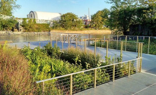
In 2010, the canal was named an EPA Superfund site, and the Sponge Park project emerged as a solution that would not only remediate the site and prevent future pollution but also improve access to a number of public spaces. Currently, the NYC area does not meet federal water quality standards for swimming, fishing, and wildlife habitats due to its inability to prevent pollution, particularly sewer overflows during heavy rain events. The water quality poses a health hazard to community members.

Gowanus Canal Sponge Park was built to manage stormwater, helping to slow, absorb, and filter polluted surface water runoff. Street runoff is captured and stored in underground tanks, which are then filtered by artificial wetlands and then released into the canal. The park is estimated to capture and treat 1 million gallons of storm water annually. This project will help to improve water quality in the surrounding waterways for recreational use and protect wildlife habitat.

The New York City Department of Environmental Protection (DEP) and Department of Design and Construction also built 70 curbside rain gardens in South Brooklyn. These additional rain gardens can manage 133,000 gallons of stormwater runoff and will capture an estimated 6 million gallons of stormwater runoff annually. Long-term, the project aims to create 11.4 acres of revitalized canal space, 7.9 acres of public spaces and 3.5 acres of remediated wetland basins.

Fig: Gowanus Canal Sponge Park (Photo retrieved from https://www.the-atlas.com/project?id=249#)

Sources

Atlas. (n.d.). Gowanus Canal Sponge Park. Retrieved from https://www.the-atlas.com/project?id=249#.

New York, New York: Build it Back Program

City: New York
Country / US State / US Territory: New York
Type of Solution: City Government Program
Climate Impact: Seal Level Rise; Hurricanes and Storm Surge; Extreme Precipitation and Flooding
Social Value Created: Affordable and Safe Housing; Social Justice and Equity for Vulnerable Communities; Public Health and Safety

The Built It Back Program was started after Hurricane Sandy struck in 2012. The Program provided homeowners, landlords, and tenants in low- and middle-income neighborhoods affected by the storm with funds sustainably rebuild homes. The goal of the program is to help vulnerable communities rebuild their homes and be better prepared for future hurricanes.

Homes must be rebuilt above Base Flood Elevation level and must be certified by Enterprise Green Communities, a certification for sustainable and energy efficient buildings, to improve communities’ resilience to flooding and Sea Level Rise. In addition to assistance in reconstructing homes, the Program funded legal counseling and temporary housing for residents affected.

The Program received 20,000 applications, and 16,000 completed the initial eligibility review. As of June 2018, the program has helped 12,500 households through reimbursement checks, construction starts, and acquisitions

Fig: A house that has been rebuilt as part of the Build It Back Program, showcasing the elevated design (Photo retrieved from https://twitter.com/NYCBuilditBack)

Fig: A house on Staten Island that has been rebuilt as part of the Build It Back Program (Photo retrieved from https://twitter.com/NYCBuilditBack)

Sources

The City of New York. (2018). NYC Build It Back Stronger and Safer: Welcome to NYC Housing Recovery. Retrieved from http://www.nyc.gov/html/recovery/html/home/home.shtml.

The Adaptation Clearinghouse. (2016). New York City Build It Back Program. Retrieved from http://www.adaptationclearinghouse.org/resources/new-york-city-build-it-back-program.html.

Miami, Florida: Citizen Science Sampling Campaign for King Tides

City: Miami
Country / US State / US Territory: Florida
Type of Solution: Awareness Campaign
Climate Impact: Sea Level Rise
Social Value Created: Public Education; Community Engagement; Social Justice and Equity for Vulnerable Communities; Public Health and Safety

During King Tides, groundwater rises and seeps up into low-lying communities. While currently these events only occur a few times a year, they could occur as frequently as 30 to 40 times a year by 2030. Florida International University (FIU) is leading a volunteer program to help map and collect data on these King Tides, helping to inform adaptation solutions.

Local community members volunteer for a few hours during these King Tides to take and record measurements in a phone application, recording the depth, length, and location of the King Tide. This method improve community awareness and helps to engage community members in solution development.

One of these sampling events, Sea Level Solutions Day, occurred on November 4, 2017. Over 75 citizen scientists volunteered, assisting in sampling in six different Miami neighborhoods. Samples were taken for traces of fecal coliform and other indicators of contamination.

Fig: Citizen scientist, Lesly Abreu, collecting flood water samples at Vizcaya Museum and Gardens for Sea Level Solutions (Photo retrieved from https://slsc.fiu.edu/solutions/outreach-and-engagement/citizen-science/sea-level-solutions-day/index.html)

Fig: Citizen scientist, Bryan Palacio, testing flood water samples for bacterial content (Photo retrieved from https://slsc.fiu.edu/solutions/outreach-and-engagement/citizen-science/sea-level-solutions-day/index.html)

Sources

Florida International University Sea Level Solutions Center. (n.d.). Citizen Science. Retrieved from https://slsc.fiu.edu/solutions/outreach-and-engagement/citizen-science/index.html.

Florida International University Sea Level Solutions Center. (n.d.). Sea Level Solutions Day. Retrieved from https://slsc.fiu.edu/solutions/outreach-and-engagement/citizen-science/sea-level-solutions-day/index.html.

New Delhi Times Bureau. (December 9, 2017). Miami citizens become scientists to study rising seas. Retrieved from https://www.newdelhitimes.com/miami-citizens-become-scientists-to-study-rising-seas/.

*Note: This case was documented from an interview with a city practitioner.

Washington, D.C.: Smart Roof Program

City: Washington
Country / US State / US Territory: D.C.
Type of Solution: Roof
Climate Impact: Extreme Temperatures and Urban Heat Island Effect
Social Value Created: Educational and Career Development Opportunities; Employment Opportunities; Public Health and Safety

Washington, D.C. has a Smart Roof Program that was implemented to counteract the Urban Heat Island (UHI) effect. The program integrated roof asset and energy management projects to retrofit roofs of 435 buildings, totalling 321 acres of roof area, including schools, police stations, fire stations, park and recreation centers, and office buildings.

Program objectives include energy conservation, stormwater management, heat reflection, solar energy production, carbon management, and leading through use of best practices and community involvement. The Washington, D.C. Department of General Services is projected to save $33 million over 20 years and will result in a reduction of 20,000 metric tons of CO2e annually. Additionally, the project addressed safety issues of the aging roofs.

The program focused on two types of roofs: vegetative (green) roofs and cool roofs. Vegetative roofs are used to teach students about botany, and solar PV installations on cool roofs are used as vocational education for students on renewable energy technologies through the DC Greenworks apprenticeship program. Projects were also used to support job creation and training in the local community.

Sources:
Bluefin. (n.d.). Success stories: SmartRoof Program makes Washington DC one of the greenest cities in America. Retrieved from http://www.bluefinllc.com/success-stories/smartroof-program-makes-washington-dc-one-of-the-greenest-city-in-america/.

Rast, Richard. (October, 2013). Washington D.C. Smart Roof Program. Bluefin.

The Adaptation Clearinghouse. (n.d.). Washington D.C. smart roof – roof asset and energy management program. Retrieved from http://www.adaptationclearinghouse.org/resources/washington-d-c-smart-roof-roof-asset-and-energy-management-program.html.

Valdivia, Chile: Parque Urbano Catrico

City: Valdivia
Country / US State / US Territory: Chile
Type of Solution:
Climate Impact: Extreme Precipitation and Flooding
Social Value Created: Public Spaces; Public Education and Awareness; Social Justice and Equity; Public Health and Safety

In Valdivia, wetland areas have been an issue for residents. Many low-income communities are located adjacent to wetland areas, which are generally sites for illicit activities and dumping. Additionally, many residents do not have accessible areas of greenspace.

Valdivia is undertaking projects to convert these wetland areas into parks that are more accessible and are better illuminated, which help to protect a valuable stormwater management asset. Converting these areas mitigates illicit activities and illegal dumping in these vulnerable communities.

One example of a park developed in a wetland area is Parque Urbano Catrico. The park is surrounded by low-income communities, and these communities are the first to have problems during extreme events. Thus, these communities are the first people engaged in the process. In the Parque Urban Catrico project, many residents are requesting grey infrastructure. However, the architects designing the process are working on educating residents on the benefits of green infrastructure, helping to improve public education and awareness.

Seattle, Washington: Elevated Floating Bridge

City: Seattle
Country / US State / US Territory: Washington
Type of Solution: Bridge
Climate Impact: Hurricanes and Extreme Storms
Social Value Created: Diverse Transportation; Public Health and Safety; Active Living and Recreation

The Washington State Department of Transportation (WSDOT) is completed reconstruction of the Evergreen Point (SR 250) floating bridge spanning Lake Washington in April 2016. The bridge is the longest floating bridge in the world. Floating bridges are support by large, water-right concrete pontoons. The bridge was reconstructed to withstand that anticipated increase in wind loads from more frequent extreme storms and hurricanes. Stronger winds may result in bridge failure by breaking the drawspan, anchor cables, or pontoons.

The new bridge design has also addressed anticipated increases in traffic congestion by increasing the width of the lands and adding a transit/High Occupancy Vehicle (HOV) lane. Additionally, there will be a new 14-foot-wide bicycle and pedestrian path that connects to recreational trails, improving recreation and increasing diversity of transportation options for commuters. The new design include flexibility for the City to add on a light rail in the future, also supporting diverse transportation options.

Sources:
Washington State Department of Transportation. (n.d.). SR 520 bridge replacement and HOV program – floating bridge facts. Retrieved from https://www.wsdot.wa.gov/Projects/SR520Bridge/About/BridgeFacts.htm.

Seattle, Washington: Elliott Bay Seawall Project

City: Seattle
Country / US State / US Territory: Washington
Type of Solution: Seawall and Living Shorelines
Climate Impact: Seal Level Rise
Social Value Created: Diverse Transportation; Public Health and Safety; Active Living and Recreation

The City of Seattle recently finished replacing an aging seawall located in Elliot Bay in 2017 that was built between 1916 and 1934. Due to risk of failure during an earthquake, a new sea wall is being constructed with a 75 year lifespan. Under advisement from the University of Washington’s Climate Impacts Group (CIG), the Seattle Department of Transportation (SDOT) is constructing a seawall using the low-probability, high-impact estimate for sea level rise, i.e. the worst projected scenario for 2100. The seawall not only protects against sea level rise, inundation, and coastal erosion, but it also supports a diverse transportation network.

The sea wall supports a highway, a ferry terminal, rail lines, biking, and walking. A pedestrian promenade and a two-way cycle track are being constructed to improve walkability and bikeability. Additionally, the seawall is designed to improve and recreate a natural aquatic shoreline habitat, such as glass blocks in the sidewalk to allow light penetration to the water below and salmon migration pathways. The project also includes reconstruction of two public piers and construction of new parks and recreational pathways.

Sources: pegNielsen. (April 23, 2014). More than just a seawall habitat: Enhancing habitat in the Elliott Bay and preserving public safety (Blog post). Retrieved from http://sdotblog.seattle.gov/2014/04/23/more-than-just-a-seawall-enhancing-habitat-in-elliott-bay-and-preserving-public-safety/.

Seattle Office of the Waterfront and Civic Projects. (n.d.). Seawall. Retrieved from https://waterfrontseattle.org/seawall.

The Adaptation Clearinghouse. (March 18, 2016). Seattle, Washington Department of Transportation (Seattle DOT) Elliott Bay Seawall Project. Retrieved from http://www.adaptationclearinghouse.org/resources/seattle-washington-department-of-transportation-seattle-dot-elliott-bay-seawall-project.html.

San Juan, Puerto Rico: Canyo Martin Pena and Enlace

City: San Juan
Country / US State / US Territory: Puerto Rico
Type of Solution: Community Group
Climate Impact: Extreme Precipitation and Flooding
Social Value Created: Public Education and Awareness; Safe and Affordable Housing; Public Health and Safety

Canyo Martin Pena and Enlace is an informational project established by the community to help mobilize community members to address mismanaged land. The community has experience flooding problems and water quality issues.

Dredging the canal would help to address flooding, community health issues, and improve water quality. Additionally, the community faces issues around land rights and the area is facing climate gentrification. Canyo Martina Pena and Enlace are also working to address these issues around housing, equity, and land titles as they work to address climate impacts.

San Francisco, California: Public Utilities Commission Green Infrastructure Projects

City: San Francisco
Country / US State / US Territory: California
Type of Solution: Green Infrastructure, Streets
Climate Impact: N/A
Social Value Created: Diverse Transportation; Public Health and Safety; Active Living and Recreation; Public Education; Urban Beautification; Social Cohesion; Public Spaces

The San Francisco Public Utilities Commission (SFPUC) is implementing various green infrastructure projects to improve stormwater management as part of its Urban Watershed Assessment. San Francisco has a combined sewer system, posing an increased risk to public health during heavy precipitation events if sewers overflow.

In addition to stormwater management, social value has been co-created by many of the projects. Many projects improve walkability and bikeability of streets, traffic calming and reduced congestion, and provide more spaces for community gatherings, which contributes to urban beautification and increased social cohesion.

Thus far, SFPUC has completed six green infrastructure projects. Eight additional projects are currently underway. These projects were identified in a participatory planning workshop held by SFPUC in 2007.

Cesar Chavez Streetscape Improvement is a demonstration project for the Better Streets Plan that was completed in the Mission neighborhood. 18 rain gardens were constructed along a half mile portion of a street. Trees and drought-tolerant landscaping were also planted to help manage stormwater. Additionally, traffic-calming bulb-outs were constructed and a bike lane was created to improve pedestrian and bicycle safe.

Newcomb Avenue Green Street is another green infrastructure project that has been completed to improve stormwater management. This project focused on creation of community gathering spaces and urban beautification in addition to traffic calming improvements. Additionally, the project helped to improve property values for residents.

Sources:
City and County of San Francisco Planning Department. (n.d.). Newcomb Avenue model block streetscape improvement project. Retrieved from http://sf-planning.org/newcomb-avenue-model-block-streetscape-improvement-project.

The Adaptation Clearinghouse. (2016). San Francisco Public Utilities Commission green infrastructure projects. Retrieved from http://www.adaptationclearinghouse.org/resources/san-francisco-public-utilities-commission-green-infrastructure-projects.html.

San Diego, California: Water Conservation Home Makeover at Chollas Creek

City: San Diego
Country / US State / US Territory: California
Type of Solution: Buildings and Housing
Climate Impact: Drought
Social Value Created: Community Engagement; Public Education; Public Health and Safety; Food Security and Nutrition; Water Security and Quality; Social Justice and Equity for Vulnerable Communities
Cost: $524,000

The Water Conservation Home Markover is a pilot project that helped neighborhoods facing issues with water and food security, many of which were Spanish speaking residents, with water conservation renovations. These renovations helped to reduce water consumption, as well as improve stormwater management. Homes were retrofitted with gray water systems, low-flow fixtures, and sink aerators. Additionally, rail barrels were installed and residents were provided with a pallet of drought tolerant landscaping plants and a low-water fruit tree, providing additional access to fresh, healthy foods.

The project also support community education. Participating residents are quarterly sent reports detailing the amount of water saved, energy saved, and carbon sequestration resulting from the project. Additionally, local schools feature the project in classroom lessons and take field trips to see the projects. An outdoor climate action center was also donated to the Millennial Tech Middle School by local landscape architects, providing a space for students to learn about drought tolerant landscaping.

Sources:
Atlas. (n.d.). Water Conservation Home Makeover at Chollas Creek. Retrieved from https://www.the-atlas.com/project?id=350.