Seattle, Washington: Redevelopment Project

City: Seattle
Country / US State / US Territory: Washington
Type of Solution: Vacant Properties and Lots
Climate Impact: Extreme Precipitation and Flooding
Social Value Created: recreation; public gathering space; social cohesion; connectivity; employment; benefits vulnerable communities

The City of Seattle recently redeveloped undertook a nine-acre redevelopment project to repurpose an underutilized parking lot and the surrounding area. The Thornton Creek restoration is one component of the restoration project. Thornton Creek was previously been forced below the surface as the urban area developed.

The restoration project aimed to restore the creek to manage stormwater runoff from 680 acres. Impervious surfaces were also reduced by 78%, improving ground water infiltration and thereby reducing runoff. Native species were used for 85% of the project’s landscaping, reducing water consumption for landscaping and reducing maintenance needs. The project design also improves stormwater filtration to remove pollutants from stormwater runoff, removing 40-80% of total suspended solids from 91% of runoff in the 680 acre drainage basin.

Thornton Place is a combined residential and commercial space created in the redevelopment. The project added 530 units of mixed-income housing and 50,000 square feet of retail space, including 143 units of assisted-living housing for seniors. Thornton Place also includes a 14-screen cinema and a plaza area for public gatherings. Additionally, pedestrian links were created to link adjacent commercial and residential neighborhoods, improving walkability. Transit access was also improve by the design, increasing mobility and diversity of transportation.

Sources:
Benfield, K. (June 6, 2011). How to turn a parking lot into an ideal green community. The Atlantic. Retrieved from https://www.theatlantic.com/national/archive/2011/06/how-to-turn-a-parking-lot-into-an-ideal-green-community/239973/.

Benfield, K. (June 7, 2011). A seattle redevelopment that is greener than green. Grist Magazine. Retrieved from https://grist.org/urbanism/2011-06-06-seattle-urbanism-transit-state-of-the-art-green-mixed-planning/.

San Juan, Puerto Rico: Resilience Hubs

City: San Juan
Country / US State / US Territory: Puerto Rico
Type of Solution: N/A
Climate Impact: Extreme Precipitation and Flooding
Social Value Created: Connectivity; Public Space

Resilience Hubs have begun to emerge in Puerto Rico. After Hurricane Maria, community members had to rely on themselves for recovery. Conventional methods of disaster management are not as effective in a community with limited access and connectivity to other countries.

Thus, the focus in Puerto Rico is to improve community connectivity and social resilience in order to empower community members to lead their own recovery. Resilience Hubs provide community members with supplies, communications, and public space to gather and reconnect with other community members after a disaster. This approach to disaster management allows these community members to take responsibility for their own protection and build capacity for both times of crisis and for normal development.

Phoenix, Arizona: Civic Space Park

City: Phoenix
Country / US State / US Territory: Arizona
Type of Solution: Park
Climate Impact: Extreme Temperatures and Urban Heat Island Effect; Air Quality; Extreme Precipitation and Flooding
Social Value Created: Public Space; Social Cohesion; Diverse Transportation; Connectivity; Active Living and Recreation; Arts and Culture

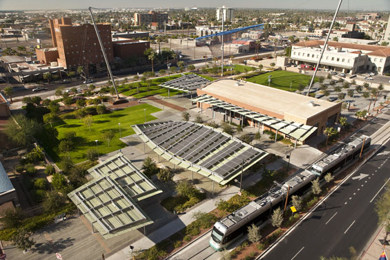
Phoenix, Arizona is a classic example of urban sprawl. The city is already facing issues with extreme temperatures, which is further amplified by the urban heat island effect. Civic Space Park is a 2.7 acre park located in Phoenix that includes green space with trees to mitigate extreme temperatures and provide shade for residents. Solar panels producing 75 kilowatts of renewable energy provide additional shade. Also, the green infrastructure improves stormwater management, which is helpful during monsoon season.

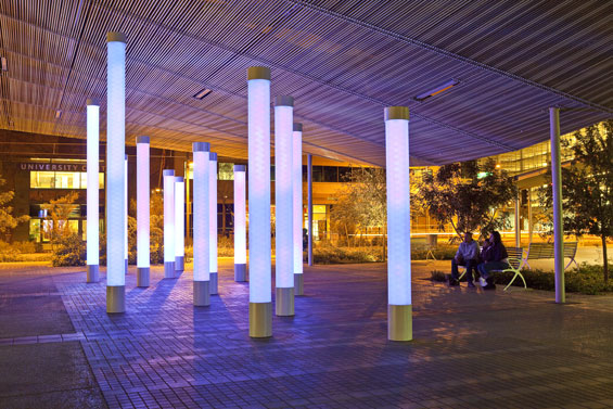
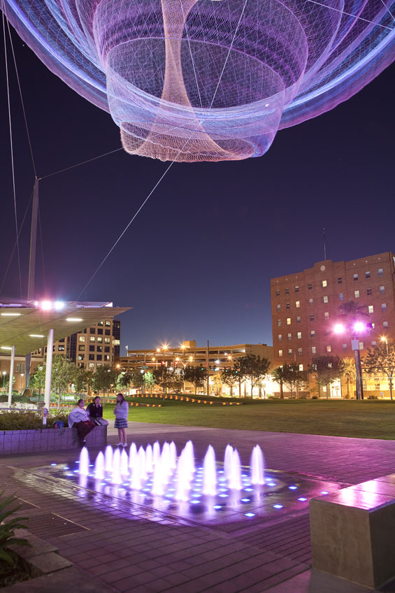
Not only is the park helpful in managing climate risks, but the park is a public space contributing the social cohesion and providing a number of other social benefits. The park features a number of artistic featurings, including a nighttime lighting show simulating lightning during a monsoon and an art installation, titled, “Her Secret is Patience.” This title arose from a phase used by Ralph Waldo Emerson that was inspired by elements of Arizona nature. There is also an interactive water feature, providing a playspace for children and adults.

The park promotes recreation and leisure, providing a turf landscape in the southwest corner of the park with pedestrian-scale retaining walls, game tables, benches, and densely spaced shade trees. The site is also located adjacent to the METRO Light Rail, increasing access to the park through improved connectivity and promoting diverse transportation.

Fig: Birds eye view of Civic Space Park (Photo retrieved from http://worldlandscapearchitect.com/civic-space-park-phoenix-usa-aecom/#.W1HvvdJKiUk)

Fig: LED lights with nighttime lighting show (Photo retrieved from http://worldlandscapearchitect.com/civic-space-park-phoenix-usa-aecom/#.W1HvvdJKiUk)

Fig: Interactive water feature with the “Her Secret is Patience” art installation above (Image retrieved from http://worldlandscapearchitect.com/civic-space-park-phoenix-usa-aecom/#.W1HvvdJKiUk)

Source: AECOM. (July 23, 2013). Civic Space Park, Phoenix USA. World Landscape Architecture. Retrieved from

*Note: This case was documented from an interview with a city practitioner.

Los Angeles, California: Green Alley

City: Los Angeles
Country / US State / US Territory: California
Type of Solution: Alleyway
Climate Impact: Extreme Temperatures and Urban Heat Island Effect; Air Quality; Extreme Precipitation and Flooding
Social Value Created: Connectivity; Diverse Transportation; Public Health and Safety; Community Engagement; Social Cohesion; Arts and Culture; Public Education and Awareness

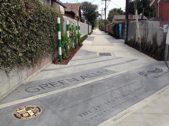
Los Angeles has over 900 of miles of alleys that are often used for dumping and experience high instances of crime. The Trust for Public Land Climate Smart Cities program is a national program for assisting cities in projects to mitigate and adapt to climate change. The Avalon Green Alley Demonstration project repurposed a mile of underutilized alleyways in South Los Angeles into green alleys.

The Trust for Public Land Climate Smart Cities collaborated with the City of Los Angeles, UCLA, and Arizona State University to create green alleys in South Los Angeles. These green alleys improve air quality and contribute to urban cooling, mitigating extreme temperatures and the urban heat island effect.

The green alley also helps to filter pollutants from stormwater runoff and control stormwater, mitigating flooding and recharging the groundwater. Additionally, the repurposed alleyways provide recreational space and improve the walkability and bikeability of the area. The green alley creates a safe passageway between various key destinations in the area, including a grocery store and nearby schools. The safe passageway improves community connectivity.

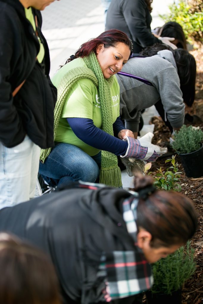
A volunteer group, Equipo Verde (Green Team), manages the green alley, organizing volunteer days, picking up garbage, and landscaping and planting trees. The group improves community engagement and educates the local community on the importance of managing these alleyways.

Fig: The Green Alley Demonstration Project completed by The Trust for Public Land (Retrieved from https://www.tpl.org/green-alleys#sm.0000ca4mkgzx8en8zd02b2m3nuov7)

Fig: Members of Equipo Verde working on the landscaping in the green alley (Retrieved from https://www.tpl.org/verde#sm.0000ca4mkgzx8en8zd02b2m3nuov7)

Sources: The Trust for Public Land. (March 17, 2016). Meet the Equipo Verde: allies for alleys. Retrieved from https://www.tpl.org/verde#sm.0000ca4mkgzx8en8zd02b2m3nuov7.

The Trust for Public Land. (n.d.). Green alleys. Retrieved from https://www.tpl.org/green-alleys#sm.0000ca4mkgzx8en8zd02b2m3nuov7.

Atlanta, Georgia: BeltLine Project

City: Atlanta
Country / US State / US Territory: Georgia
Type of Solution: Railways
Climate Impact: Extreme Temperatures and Urban Heat Island Effect; Air Quality; Extreme Precipitation and Flooding
Social Value Created: Diverse Transportation; Connectivity; Water Security and Quality; Active Living and Playspaces

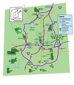
Fig: Map of the Atlanta BeltLine (Retrieved from https://beltline.org/about/the-atlanta-beltline-project/atlanta-beltline-overview/)
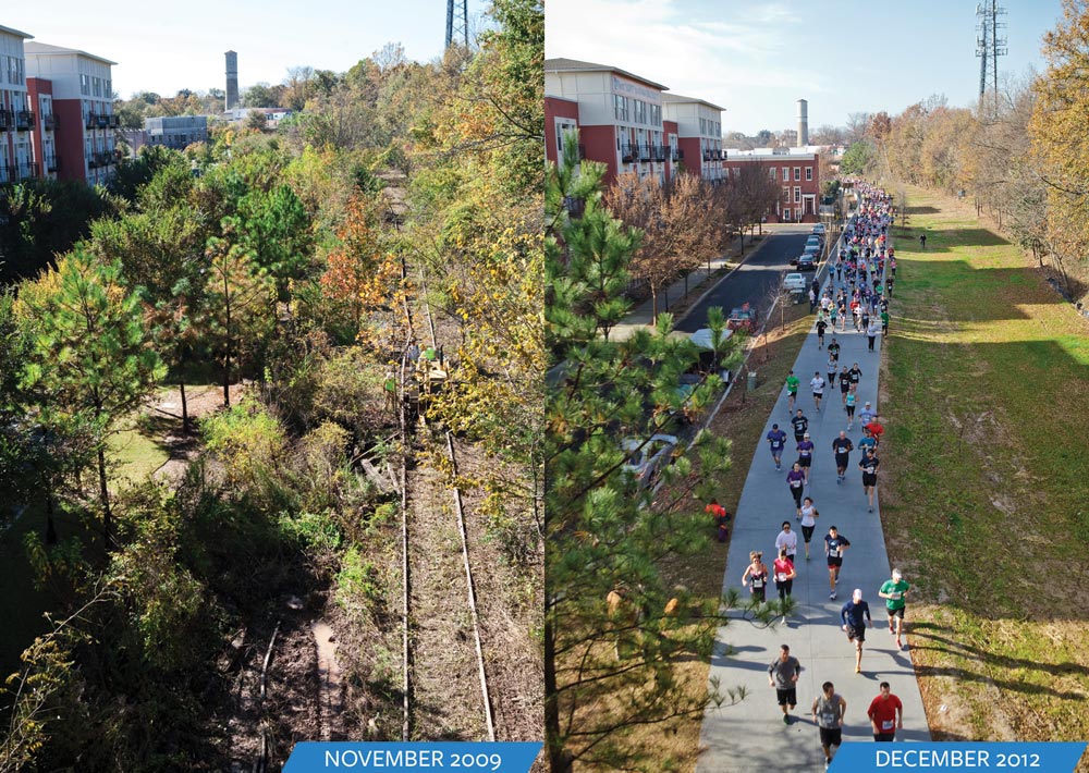
The Atlanta BeltLine project is a rails to trails project that is converting 22 miles of abandoned railway beds into recreational trails for biking and pedestrians, as well as a streetcar line. The project will restore 700 acres of greenspace and create an additional 1,300 acres of greenspace. The $4.8 billion project begun in 2006 and is expected to be completed in 2030.

Greenspace improves air quality and contributes to urban cooling, counteracting extreme temperatures and the urban heat island effect. Additionally, the green infrastructure slows and captures stormwater during heavy rain events, presenting flooding.

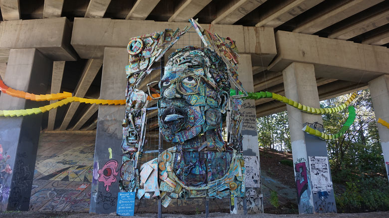
The BeltLine project also creates social value for the community. The BeltLine project increases diversity of transportation and improves connectivity between 45 neighborhoods of varying socioeconomic statuses and ethnicities. The greenspace will also help to filter water, improving water quality. Another unique feature of the BeltLine project is an outdoor public art-exhibit, displaying the work of more than 70 artists over the course of 9 miles of the BeltLine, contributing to the city’s arts and culture.

Fig: Before and after completion of the Eastside Trail portion of the BeltLine (Retrieved from https://beltline.org/places-to-go/eastside-trail/)

Fig: William Massey’s “The Art of Reconciliation” sculpture, an example of art displayed on the BeltLine trail (Retrieved from https://www.wheretraveler.com/atlanta/art-beltline)

Sources: Historic Fourth Ward Park Conservancy. (n.d.). Clear Creek Basin. Retrieved from http://www.h4wpc.org/clear-creek-basin/.

The Adaptation Clearinghouse. (n.d.). Case study of the Atlanta BeltLine – adaptation aspects. Retrieved from http://www.adaptationclearinghouse.org/resources/case-study-of-the-atlanta-beltline-adaptation-aspects.html.

WhereTraveler. (n.d.). Art on the beltline. Retrieved from https://www.wheretraveler.com/atlanta/art-beltline.