Seal Level Rise

New York, New York: Living Breakwaters

City: New York
Country / US State / US Territory: New York
Type of Solution: Seawalls and Living Shorelines
Climate Impact: Seal Level Rise; Hurricanes and Storm Surge; Extreme Precipitation and Flooding
Social Value Created: Educational and Career Development Opportunities; Active Living and Recreation; Community Engagement; Social Cohesion; Arts and Culture
Cost: $60 million
Funding Source: U.S. Department of Housing and Urban Development Rebuild by Design competition

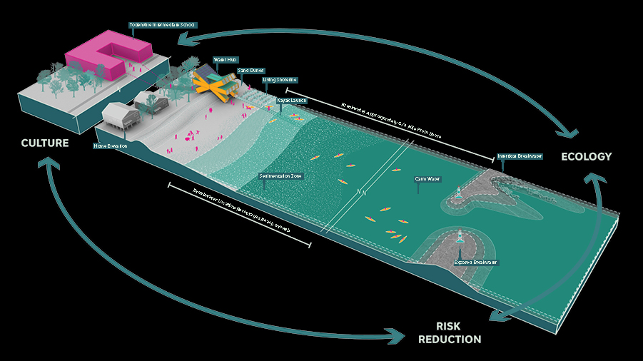
Living Breakwaters is a project aimed at helping to reduce wave energy, lowering flooding risks during extreme storm events. The project was developed by SCAPE landscape Architecture for the Rebuild Design Competition, a competition held by the U.S. Department of Housing and Urban Development (HUD) to improve coastal resilience in response to Hurricane Sandy.

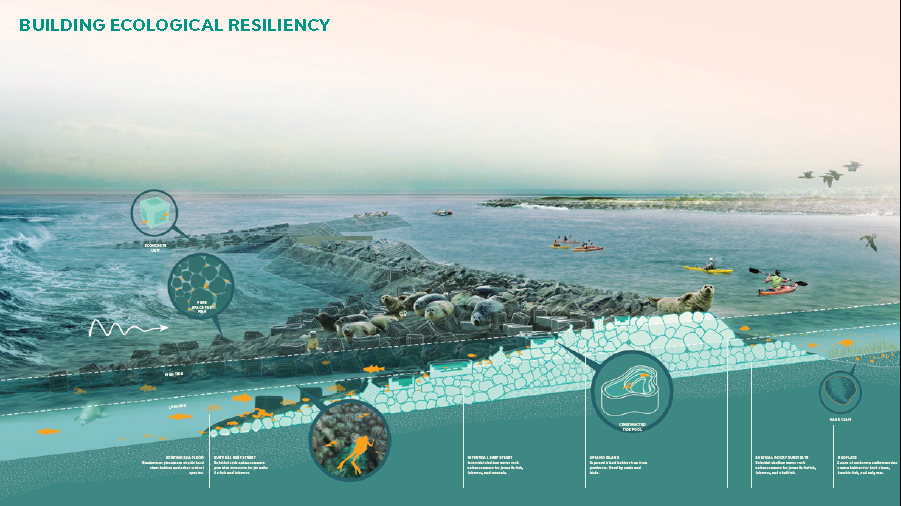
The Living Breakwaters approach uses structures to restore and enhance marine habitats, as well as improve biodiversity. Structures include reef ridges, reef streets, crenulated crests, and bio-enhancing concrete. This habitat mimics historic oyster reefs, which helps to restore the oyster population.

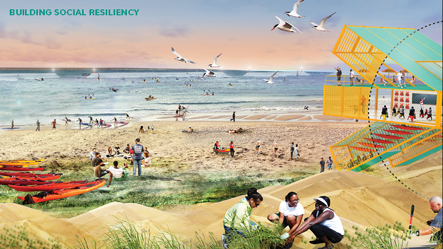
Additionally, the project co-creates social value. The project will help to prevent beach erosion and protect property values. The project also will improves access to the shoreline an recreational opportunities such as boating and fishing.

Also, an on-land Water Hub will be constructed on shore for visitoring groups, recreation, and educational programs. The Harbor School and Billion Oyster Project will create educational opportunities for local schools to learn about ecological stewardship and how they can help to protect Staten Island’s coastline. Implementation of the project also provides educational opportunities for research and skill development through project monitoring.

Fig: Graphic showing the project design and connection between risk reduction, ecology, and culture (Image retrieved from http://www.rebuildbydesign.org/our-work/all-proposals/winning-projects/ny-living-breakwaters)

Fig: Graphic showing more specifics about the project’s landscape architecture design (Image retrieved from http://www.rebuildbydesign.org/our-work/all-proposals/winning-projects/ny-living-breakwaters)

Fig: Rendering of the Living Breakwaters project featuring contributions to social resilience (Image retrieved from http://www.rebuildbydesign.org/our-work/all-proposals/winning-projects/ny-living-breakwaters)

Sources

Atlas. (n.d.). Creating protective infrastructure to reduce coastal risk, enhance aquatic habitat, and foster social resilience. Retrieved from https://www.the-atlas.com/project?id=374#.

New York State. (n.d.). Learn more about the Living Breakwaters project. Retrieved from https://stormrecovery.ny.gov/learn-more-about-living-breakwaters-project.

Rebuild by Design. (n.d.). Living Breakwaters. Retrieved from http://www.rebuildbydesign.org/our-work/all-proposals/winning-projects/ny-living-breakwaters.

New York, New York: Build it Back Program

City: New York
Country / US State / US Territory: New York
Type of Solution: City Government Program
Climate Impact: Seal Level Rise; Hurricanes and Storm Surge; Extreme Precipitation and Flooding
Social Value Created: Affordable and Safe Housing; Social Justice and Equity for Vulnerable Communities; Public Health and Safety

The Built It Back Program was started after Hurricane Sandy struck in 2012. The Program provided homeowners, landlords, and tenants in low- and middle-income neighborhoods affected by the storm with funds sustainably rebuild homes. The goal of the program is to help vulnerable communities rebuild their homes and be better prepared for future hurricanes.

Homes must be rebuilt above Base Flood Elevation level and must be certified by Enterprise Green Communities, a certification for sustainable and energy efficient buildings, to improve communities’ resilience to flooding and Sea Level Rise. In addition to assistance in reconstructing homes, the Program funded legal counseling and temporary housing for residents affected.

The Program received 20,000 applications, and 16,000 completed the initial eligibility review. As of June 2018, the program has helped 12,500 households through reimbursement checks, construction starts, and acquisitions

Fig: A house that has been rebuilt as part of the Build It Back Program, showcasing the elevated design (Photo retrieved from https://twitter.com/NYCBuilditBack)

Fig: A house on Staten Island that has been rebuilt as part of the Build It Back Program (Photo retrieved from https://twitter.com/NYCBuilditBack)

Sources

The City of New York. (2018). NYC Build It Back Stronger and Safer: Welcome to NYC Housing Recovery. Retrieved from http://www.nyc.gov/html/recovery/html/home/home.shtml.

The Adaptation Clearinghouse. (2016). New York City Build It Back Program. Retrieved from http://www.adaptationclearinghouse.org/resources/new-york-city-build-it-back-program.html.

Miami, Florida: Wagner Creek Restoration

City: Miami
Country / US State / US Territory: Florida
Type of Solution: Habitat Restoration
Climate Impact: Seal level rise; Hurricanes and Storm Surge; Extreme Precipitation and Flooding
Social Value Created: Public Education; Community Engagement; Community Wellbeing and Quality of Life; Urban Beautification
Cost: $18.4 million
Funding Source: Public Space Challenge grant

The Nature Conservancy (TNC) partnered with Greater Miami and the Beaches on a project to revitalize Wagner Creek. Over the years, Wagner Creek has been a site of illegal dumping, leaking pipe systems, and stormwater runoff from nearby auto-repair shops, making it one of the most polluted water bodies in Florida. The project will use green infrastructure improve stormwater management in response to flooding from heavy precipitation events and storm surge, as well as to remove pollutants and improve water quality.

Green infrastructure also provides shade, helping to cool the urban environment and mitigate extreme temperatures and the urban heat island effect. Additionally, the project aims to improve community well-being and contribute to urban beautification.

During the design phase of the project, TNC held a public visioning workshop that engaged stakeholders with various backgrounds. Stakeholders identified different services the project could provide and were given stickers to prioritize these services, such as larger/smaller parking lots, parks, tree plantings, and improve water quality for recreation. Then, the University of Miami Landscape Architecture department assisted with developing designs that could be implemented, incorporating climate change projections and other datasets, contributing to the advancement of education. A number of parks are planned as part of the project, and these parks will serve an estimated 100,000 people that live and work in the area.

Fig: Wagner Creek (Photo retrieved from https://www.nature.org/ourinitiatives/regions/northamerica/unitedstates/florida/explore/florida-wagner-creek-restoration.xml)

Fig: Residents prioritizing services during vision workshop (Photo retrieved from https://communitynewspapers.com/brickell/the-nature-conservancy-launches-effort-to-revitalize-the-banks-of-wagner-creek/)

Sources:

Heffernan, J. (November 25, 2017). The Nature Conservancy launches effort to revitalize the banks of Wagner Creek. Miami’s Community Newspapers. Retrieved from https://communitynewspapers.com/brickell/the-nature-conservancy-launches-effort-to-revitalize-the-banks-of-wagner-creek/.

The Nature Conservancy. (November 8, 2017). The Nature Conservancy to revitalize Wagner Creek. Retrieved from https://www.nature.org/ourinitiatives/regions/northamerica/unitedstates/florida/newsroom/florida-revitalizing-miamis-wagner-creek.xml.

The Nature Conservancy. (n.d.). The greening of Wagner Creek. Retrieved from https://www.nature.org/ourinitiatives/regions/northamerica/unitedstates/florida/explore/florida-wagner-creek-restoration.xml.

*Note: This case was documented from an interview with a city practitioner.

Miami, Florida: Citizen Science Sampling Campaign for King Tides

City: Miami
Country / US State / US Territory: Florida
Type of Solution: Awareness Campaign
Climate Impact: Sea Level Rise
Social Value Created: Public Education; Community Engagement; Social Justice and Equity for Vulnerable Communities; Public Health and Safety

During King Tides, groundwater rises and seeps up into low-lying communities. While currently these events only occur a few times a year, they could occur as frequently as 30 to 40 times a year by 2030. Florida International University (FIU) is leading a volunteer program to help map and collect data on these King Tides, helping to inform adaptation solutions.

Local community members volunteer for a few hours during these King Tides to take and record measurements in a phone application, recording the depth, length, and location of the King Tide. This method improve community awareness and helps to engage community members in solution development.

One of these sampling events, Sea Level Solutions Day, occurred on November 4, 2017. Over 75 citizen scientists volunteered, assisting in sampling in six different Miami neighborhoods. Samples were taken for traces of fecal coliform and other indicators of contamination.

Fig: Citizen scientist, Lesly Abreu, collecting flood water samples at Vizcaya Museum and Gardens for Sea Level Solutions (Photo retrieved from https://slsc.fiu.edu/solutions/outreach-and-engagement/citizen-science/sea-level-solutions-day/index.html)

Fig: Citizen scientist, Bryan Palacio, testing flood water samples for bacterial content (Photo retrieved from https://slsc.fiu.edu/solutions/outreach-and-engagement/citizen-science/sea-level-solutions-day/index.html)

Sources

Florida International University Sea Level Solutions Center. (n.d.). Citizen Science. Retrieved from https://slsc.fiu.edu/solutions/outreach-and-engagement/citizen-science/index.html.

Florida International University Sea Level Solutions Center. (n.d.). Sea Level Solutions Day. Retrieved from https://slsc.fiu.edu/solutions/outreach-and-engagement/citizen-science/sea-level-solutions-day/index.html.

New Delhi Times Bureau. (December 9, 2017). Miami citizens become scientists to study rising seas. Retrieved from https://www.newdelhitimes.com/miami-citizens-become-scientists-to-study-rising-seas/.

*Note: This case was documented from an interview with a city practitioner.

Seattle, Washington: Elliott Bay Seawall Project

City: Seattle
Country / US State / US Territory: Washington
Type of Solution: Seawall and Living Shorelines
Climate Impact: Seal Level Rise
Social Value Created: Diverse Transportation; Public Health and Safety; Active Living and Recreation

The City of Seattle recently finished replacing an aging seawall located in Elliot Bay in 2017 that was built between 1916 and 1934. Due to risk of failure during an earthquake, a new sea wall is being constructed with a 75 year lifespan. Under advisement from the University of Washington’s Climate Impacts Group (CIG), the Seattle Department of Transportation (SDOT) is constructing a seawall using the low-probability, high-impact estimate for sea level rise, i.e. the worst projected scenario for 2100. The seawall not only protects against sea level rise, inundation, and coastal erosion, but it also supports a diverse transportation network.

The sea wall supports a highway, a ferry terminal, rail lines, biking, and walking. A pedestrian promenade and a two-way cycle track are being constructed to improve walkability and bikeability. Additionally, the seawall is designed to improve and recreate a natural aquatic shoreline habitat, such as glass blocks in the sidewalk to allow light penetration to the water below and salmon migration pathways. The project also includes reconstruction of two public piers and construction of new parks and recreational pathways.

Sources: pegNielsen. (April 23, 2014). More than just a seawall habitat: Enhancing habitat in the Elliott Bay and preserving public safety (Blog post). Retrieved from http://sdotblog.seattle.gov/2014/04/23/more-than-just-a-seawall-enhancing-habitat-in-elliott-bay-and-preserving-public-safety/.

Seattle Office of the Waterfront and Civic Projects. (n.d.). Seawall. Retrieved from https://waterfrontseattle.org/seawall.

The Adaptation Clearinghouse. (March 18, 2016). Seattle, Washington Department of Transportation (Seattle DOT) Elliott Bay Seawall Project. Retrieved from http://www.adaptationclearinghouse.org/resources/seattle-washington-department-of-transportation-seattle-dot-elliott-bay-seawall-project.html.

San Francisco, California: Baylands Restoration

City: San Francisco
Country / US State / US Territory: California
Type of Solution: Habitat Restoration
Climate Impact: Seal Level Rise; Hurricanes and Storm Surge; Extreme Precipitation and Flooding
Social Value Created: Community Engagement; Employment Opportunities; Water Security and Quality; Property Values; Active Living and Recreation; Urban Beautification

San Francisco has set a goal to restore 100,000 acres of the bay’s tidal marshes. A 2015 study projects that most of the existing marshes will be damaged or destroyed by 2100. The City has identified restoration of marshes as a strategy for managing sea level rise, as it provides the community with other socially value co-benefits unlike other sea level rise solutions.

Through restoration initiatives and innovative strategies, marshes can be restored and enhanced to prepare for sea level rise and coastal flooding. Additionally, the marshes help to filter pollutants out of runoff to improve water quality, and they provide habitat for many at-risk species and species critical to the economy, such as Dungeness crab and salmon. Further, restoration projects help to control coastal erosion of water front properties.

Sonoma Land Trust acquired 1,000 acres of tidal marshes in the Sears Point Wetland along the northern shore of San Francisco Bay. For the project, 285 feet of an existing levee was breached to restore previous marsh land, creating a “habitat” levee using marsh mounds, or raise “islands”. 500 marsh mounds were constructed, each of which are 6 feet tall and 50-75 feet wide, using reclaimed sediment. These mounds support marsh accretion and provide cover for nesting birds from the rising tides and waves during storms. The “habitat” levee both protects the adjacent a nearby highway and railroad and provides additional wildlife habitat.

The project also includes the development of a 2.5 mile section of the Bay Trail, a recreational trail running through the marshes. This addition will provide users with views of Mt. Tamalpais, Mt. Diablo, and the San Francisco skyline, as well as include new benches, interpretive signs, and parking.

South Bay Salt Pond Restoration Project is another project underway, seeking to restore 15,100 acres of former commercial salt ponds to functional tidal marshes. The Project is will manage coastal flooding, as well as improve wildlife habitat and increase public recreational access. A 400 foot berm will be constructed to help control flooding. 16 islands, each 15,000 square feet, will also be constructed. Levees will also be lowered and breeched to restore 130 acres of tidal pools.

In addition to flooding control measures, public recreational trails will be realigned and resurfaced to improve public access, and two overlooks and four interpretive panels will be installed.

Environmental Protection Agency. (n.d.). South Bay Salt Pond Tidal Marsh Restoration at Pond A17 Project. Retrieved from https://www.epa.gov/sfbay-delta/south-bay-salt-pond-tidal-marsh-restoration-pond-a17-project.

Small-Lorenz, S. L., Stein, B. A., Schrass, K., Holstein, D. N., & Mehta, A. V. (2016). Natural defenses in action: harnessing nature to protect our communities. National Wildlife Foundation, Washington, D.C. Retrieved from https://www.nwf.org/~/media/PDFs/Global-Warming/Reports/NWF_Natural-Defenses-in-Action_Report.pdf.

Sonoma Land Trust. (June 6, 2014). Sonoma Land Trust and Ducks Unlimited kick off construction of Sears Point 960-Acre Wetland Restoration Project on San Pablo Bay. Retrieved from https://www.sonomalandtrust.org/news_room/press_releases/1406-sears-point.html.

Sonoma Land Trust. (n.d.). Seas Point Wetland Restoration Project groundbreaking FAQs. Retrieved from https://sonomalandtrust.org/news-room/jenner-information-kit/faq/.

South Bay Salt Pond Restoration Project. (n.d.). Project description. Retrieved from http://www.southbayrestoration.org/Project_Description.html.

Wood, J., Pitkin, M., Meisler, J., DiPietro, D., Graffis, A., & Fris, R. (January 17, 2018). Saving tidal marshes in the San Francisco Bay. U.S. Climate Resilience Toolkit. Retrieved from https://toolkit.climate.gov/case-studies/saving-tidal-marshes-san-francisco-bay.

Miami Florida, Citizens Oversight Board for Miami Forever Bond

City: Miami
Country / US State / US Territory: Florida
Type of Solution: Awareness Campaign / Community Outreach and Education Program
Climate Impact: Sea Level Rise; Hurricanes and Extreme Storms; Extreme Precipitation and Flooding
Social Value Created: Community Engagement; Social Justice and Equity for Vulnerable Communities

Miami faces flooding risks due to sea level rise and inundation, extreme precipitation, and hurricanes and storm surge. Miami received a $400 million general obligation bond (GOB), and $192 million of the bond was dedicated to projects to manage sea level rise and flooding. GOBs are typically used for non-bankable projects, which are projects where there is not a consistent stream of revenue generated. Projects will include solutions such as drainage systems and anti-flooding pumps, raised roads, and sea walls.

The Citizens Oversight Board was created to help oversee these projects and allow for residents to have input into the projects. Local community non-profit organizations, Catalyst Miami and Miami Climate Alliance, provided recommended criteria for board members selected. For example, the board members must reflect the overall composition / demographics of the city, composed of a diverse group of residents.

The Citizens Oversight Board review process includes examination of projects’ social, environmental, and economic benefits. Projects aim help to address socioeconomic inequality issues affecting vulnerable communities, as well.

Fig: Graphic showing a drainage system and anti-flooding pumps, raised road, and seawall (Photos Retrieved from https://www.miamiforever.org/)

Fig: Flyer distributed by Miami Climate Alliance asking community members to request use of the recommended criteria for the selection Citizen Oversight Board members. (Photo Retrieved from https://allevents.in/miami-dade%20county/miami-forever-bond-community-town-hall/2127379124215298 )

Sources:
City of Miami. [City of Miami Gov]. (September 22, 2017). City of Miami Forever General Obligation Bond [Video File]. Retrieved from http://miamigov.com/miamiforever/#faq.

Flechas, J. (March 23, 2018). Miami will spend $400 million on drainage, housing and parks. How can residents have a say? Miami Herald. Retrieved from https://www.miamiherald.com/news/local/community/miami-dade/article206618409.html.

Miami Forever. Investing in Infrastructure. Retrieved from https://www.miamiforever.org/.

Stein, K. (November 9, 2017). What’s next on the $400 million Miami Forever Bond. WLRN. Retrieved from http://wlrn.org/post/whats-next-400-million-miami-forever-bond.

Urban Environment League of Greater Miami (UEL). (November 4, 2017). Taking a look at the Miami Forever Bond. UEL. Retrieved from http://uel.org/2017/11/04/taking-a-look-at-the-miami-forever-bond/

*Note: This case was documented from an interview with a city practitioner.

Miami, Florida: King Tide Outreach Program

City: Miami
Country / US State / US Territory: Florida
Type of Solution: Awareness Campaign
Climate Impact: Sea level rise and inundation, extreme precipitation and flooding, hurricanes and storm surge
Social Value Created: Public Education and Awareness; Community Engagement; Social Justice and Equity for Vulnerable Communities

Many coastal areas are currently privately owned. Miami is low lying, so both coastal and non-coastal areas will flood due to sea level rise, heavy precipitation events, and hurricanes and storm surge. The King Tide Outreach Program is an awareness campaign launched by the City of Miami. Community non-profits partnered with the City of Miami to hold the campaign.

Last fall, the King Tide Outreach Program focused on educating Shore Crest, a mixed income and diverse neighborhood. Many residents are renters and are unaware of the causes of flooding. Residents have had issues with being able to go to work during flooding events.

The campaign engaged in a number of outreach activities, including social media, door to door messaging, and distribution of digital flyers. The City of Miami used Facebook and Twitter messages to communicate information to followers. The Facebook page has 6,423 followers, and the Twitter page has 111,000 followers. A Youtube video titled, “City of Miami – King Tides in Shorecrest,” was created as another educational communication during a Citizen Science collection day. The video has received 1,325 views thus far.

Prior to each King Tide event, messages were posted on New Door to directly reach City of Miami residents. An estimated 15,500 residents were reached for Citywide King Tide messages, and an estimated 125 residents were reached in the targeted Shorecrest/Haynsworth Village messages.

The Upper Eastside NET office served as an outreach post for Shorecrest residents, providing King Tide information and resources. Between 10 to 15 residents contacted the NET Offices for more information about the King Tides. Additionally, four community meetings were held and seven variable message signs were placed around the city to warn of King Tides.

Fig: Example of digital flyer distributed via Twitter, showing safety information on the front (left) and a map of affected areas on the back (left) (Image retrieved from https://twitter.com/CityofMiami/status/926777359327547392)

Sources

*Note: This case was documented from an interview with a city practitioner.

Miami, Florida: Eyes on the Rise Toolkit

City: Miami
Country / US State / US Territory: Florida
Type of Solution: Awareness Campaign / Community Outreach and Education Program
Climate Impact: Seal Level Rise; Hurricanes and Storm Surge; Extreme Precipitation and Flooding
Social Value Created: Public Education; Community Engagement; Social Justice and Equity for Vulnerable Communities

The Eyes on the Rise Toolkit is a Florida International University project that is aimed at informing citizens of South Florida about the potential impact of sea level rise in their neighborhoods. The Toolkit is an application that allows citizens to enter their location to see a sea level rise simulation and show elevation data.

Citizens are also provided with data and resources, including flooding reports, flood insurance data, tide measurement, elevation, and groundwater levels. Citizens can also use the application to report a flood. The Toolkit is aimed to help improve community knowledge systems, increasing community awareness and engage vulnerable communities in sea level rise adaptation.

Fig: Eyes on the Rise Toolkit application interface (Photo retrieved from http://citizeneyes.org/app/)

Sources: Eyes on the Rise. (n.d.). About the app. Retrieved from http://www.eyesontherise.org/about-the-app/.

*Note: This case was documented from an interview with a city practitioner.

Miami, Florida: CLEAR Miami

City: Miami
Country / US State / US Territory: Florida
Type of Solution: Volunteer / Community Group Program
Climate Impact: Seal Level Rise; Hurricanes and Storm Surge; Extreme Heat and Urban Heat Island Effect; Infectious Disease
Social Value Created: Public education and awareness, community engagement, social cohesion, benefits vulnerable communities

Catalyst Miami is a community organization that has conventionally focused on providing social services, such as health coaching and financial planning. Recently, the group has begun to engage vulnerable communities in local climate initiatives.

In 2016, Catalyst Miami launched its CLEAR Miami (Community Leadership on the Environment, Advocacy, and Resilience) program. CLEAR Miami is a 12 week program that teaches residents how to participate in the climate planning process, including the basics of climate change science, types of adaptation strategies, communication skills for public speaking, and how to create an asset map for their neighborhoods.

Community members learn about the risk of Seal Level Rise and Inundation, hurricanes and storm surge, extreme heat and the urban heat island effect, and the spread of infectious disease. The program focuses on financially vulnerable populations given their disproportionate level of risks to climate impacts. Those who participate in the program are provided dinner and childcare for free.

The Southeast Florida Climate Compact is working on updating an adaptation plan and developing a mitigation plan. Catalyst Miami is working on engaging residents in this planning process to ensure equitable solutions are chosen.

Fig: The first CLEAR Miami graduates (Photo retrieved from https://catalystmiami.org/climate-resilience-local-engagement/)

Fig: CLEAR Miami Youth graduates talking about why they advocate for climate change (Photo retrieved from https://catalystmiami.org/climate-resilience-local-engagement/)

Sources: Delahunty, M. (2016). Catalyst Miami launches pioneering climate resilience training in South Florida. Catalyst Miami. Retrieved from

United States Water Alliance. (2017). An equitable water future: a national briefing paper. Retrieved from http://uswateralliance.org/sites/uswateralliance.org/files/publications/uswa_waterequity_FINAL.pdf

*Note: This case was documented from an interview with a city practitioner.