City: Seattle Country / US State / US Territory: Washington Type of Solution: Bridge Climate Impact: Hurricanes and Extreme Storms Social Value Created: Diverse Transportation; Public Health and Safety; Active Living and Recreation
The Washington State Department of Transportation (WSDOT) is completed reconstruction of the Evergreen Point (SR 250) floating bridge spanning Lake Washington in April 2016. The bridge is the longest floating bridge in the world. Floating bridges are support by large, water-right concrete pontoons. The bridge was reconstructed to withstand that anticipated increase in wind loads from more frequent extreme storms and hurricanes. Stronger winds may result in bridge failure by breaking the drawspan, anchor cables, or pontoons.
The new bridge design has also addressed anticipated increases in traffic congestion by increasing the width of the lands and adding a transit/High Occupancy Vehicle (HOV) lane. Additionally, there will be a new 14-foot-wide bicycle and pedestrian path that connects to recreational trails, improving recreation and increasing diversity of transportation options for commuters. The new design include flexibility for the City to add on a light rail in the future, also supporting diverse transportation options.
City: Seattle Country / US State / US Territory: Washington Type of Solution: Seawall and Living Shorelines Climate Impact: Seal Level Rise Social Value Created: Diverse Transportation; Public Health and Safety; Active Living and Recreation
The City of Seattle recently finished replacing an aging seawall located in Elliot Bay in 2017 that was built between 1916 and 1934. Due to risk of failure during an earthquake, a new sea wall is being constructed with a 75 year lifespan. Under advisement from the University of Washington’s Climate Impacts Group (CIG), the Seattle Department of Transportation (SDOT) is constructing a seawall using the low-probability, high-impact estimate for sea level rise, i.e. the worst projected scenario for 2100. The seawall not only protects against sea level rise, inundation, and coastal erosion, but it also supports a diverse transportation network.
The sea wall supports a highway, a ferry terminal, rail lines, biking, and walking. A pedestrian promenade and a two-way cycle track are being constructed to improve walkability and bikeability. Additionally, the seawall is designed to improve and recreate a natural aquatic shoreline habitat, such as glass blocks in the sidewalk to allow light penetration to the water below and salmon migration pathways. The project also includes reconstruction of two public piers and construction of new parks and recreational pathways.
Sources: pegNielsen. (April 23, 2014). More than just a seawall habitat: Enhancing habitat in the Elliott Bay and preserving public safety (Blog post). Retrieved from http://sdotblog.seattle.gov/2014/04/23/more-than-just-a-seawall-enhancing-habitat-in-elliott-bay-and-preserving-public-safety/.
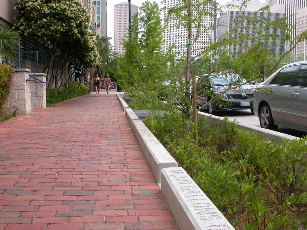
City: San Francisco Country / US State / US Territory: California Type of Solution: Green Infrastructure, Streets Climate Impact: N/A Social Value Created: Diverse Transportation; Public Health and Safety; Active Living and Recreation; Public Education; Urban Beautification; Social Cohesion; Public Spaces
The San Francisco Public Utilities Commission (SFPUC) is implementing various green infrastructure projects to improve stormwater management as part of its Urban Watershed Assessment. San Francisco has a combined sewer system, posing an increased risk to public health during heavy precipitation events if sewers overflow.
In addition to stormwater management, social value has been co-created by many of the projects. Many projects improve walkability and bikeability of streets, traffic calming and reduced congestion, and provide more spaces for community gatherings, which contributes to urban beautification and increased social cohesion.
Thus far, SFPUC has completed six green infrastructure projects. Eight additional projects are currently underway. These projects were identified in a participatory planning workshop held by SFPUC in 2007.
Cesar Chavez Streetscape Improvement is a demonstration project for the Better Streets Plan that was completed in the Mission neighborhood. 18 rain gardens were constructed along a half mile portion of a street. Trees and drought-tolerant landscaping were also planted to help manage stormwater. Additionally, traffic-calming bulb-outs were constructed and a bike lane was created to improve pedestrian and bicycle safe.
Newcomb Avenue Green Street is another green infrastructure project that has been completed to improve stormwater management. This project focused on creation of community gathering spaces and urban beautification in addition to traffic calming improvements. Additionally, the project helped to improve property values for residents.
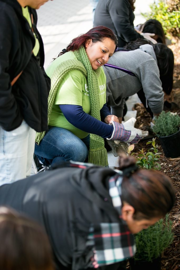
City: Phoenix Country / US State / US Territory: Arizona Type of Solution: Volunteer / Community Group Climate Impact: Extreme Temperatures and Urban Heat Island Effect; Air Quality; Extreme Precipitation and Flooding Social Value Created: Social Justice and Equity for Vulnerable Communities; Community Engagement; Public Education; Diverse Transportation; Public Health and Safety; Urban Beautification; Community Wellbeing and Quality of Life
The City of Phoenix is participating in the national Resilience AmeriCorps program. The local program is called Resilient PHX. Volunteers assist low-income communities with projects to build community capacity. Resilient PHX has already completed a number of projects, such as Grandview Message Boards, Grand Avenue Curb Cut/Rain Garden, and Triangle Tree Planting.
Three message boards were installed in the Grandview Neighborhood to improve communication of climate risks, such as the risks of extreme heat in vulnerable communities, specifically low-income residents, elderly residents, and renters.
Another project was the Grand Avenue Curb Cut/Rain Garden. The curb cut/rain garden improves stormwater management to prevent flooding risks during heavy precipitation events. In addition to improved stormwater management, the project created more greenspace for residents and improved aesthetics, walkability, and shade coverage.
Lastly, the Triangle Tree Planting project was a community outreach program that engaged residents in tree planting and taught residents tree maintenance in an effort to mitigate extreme heat and the heat island effect. Trees increase shade coverage, which also contributes the the walkability of the area.
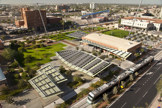
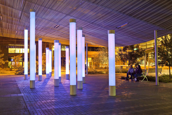
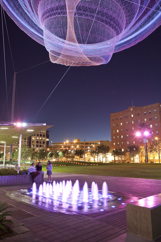
City: Phoenix Country / US State / US Territory: Arizona Type of Solution: Park Climate Impact: Extreme Temperatures and Urban Heat Island Effect; Air Quality; Extreme Precipitation and Flooding Social Value Created: Public Space; Social Cohesion; Diverse Transportation; Connectivity; Active Living and Recreation; Arts and Culture
Phoenix, Arizona is a classic example of urban sprawl. The city is already facing issues with extreme temperatures, which is further amplified by the urban heat island effect. Civic Space Park is a 2.7 acre park located in Phoenix that includes green space with trees to mitigate extreme temperatures and provide shade for residents. Solar panels producing 75 kilowatts of renewable energy provide additional shade. Also, the green infrastructure improves stormwater management, which is helpful during monsoon season.
Not only is the park helpful in managing climate risks, but the park is a public space contributing the social cohesion and providing a number of other social benefits. The park features a number of artistic featurings, including a nighttime lighting show simulating lightning during a monsoon and an art installation, titled, “Her Secret is Patience.” This title arose from a phase used by Ralph Waldo Emerson that was inspired by elements of Arizona nature. There is also an interactive water feature, providing a playspace for children and adults.
The park promotes recreation and leisure, providing a turf landscape in the southwest corner of the park with pedestrian-scale retaining walls, game tables, benches, and densely spaced shade trees. The site is also located adjacent to the METRO Light Rail, increasing access to the park through improved connectivity and promoting diverse transportation.
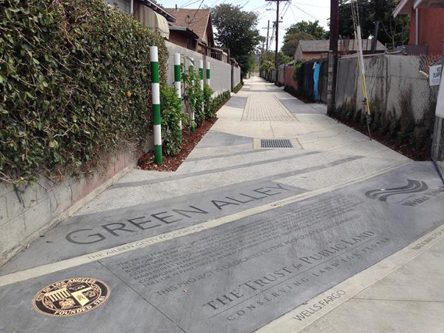
City: Los Angeles Country / US State / US Territory: California Type of Solution: Alleyway Climate Impact: Extreme Temperatures and Urban Heat Island Effect; Air Quality; Extreme Precipitation and Flooding Social Value Created: Connectivity; Diverse Transportation; Public Health and Safety; Community Engagement; Social Cohesion; Arts and Culture; Public Education and Awareness
Los Angeles has over 900 of miles of alleys that are often used for dumping and experience high instances of crime. The Trust for Public Land Climate Smart Cities program is a national program for assisting cities in projects to mitigate and adapt to climate change. The Avalon Green Alley Demonstration project repurposed a mile of underutilized alleyways in South Los Angeles into green alleys.
The Trust for Public Land Climate Smart Cities collaborated with the City of Los Angeles, UCLA, and Arizona State University to create green alleys in South Los Angeles. These green alleys improve air quality and contribute to urban cooling, mitigating extreme temperatures and the urban heat island effect.
The green alley also helps to filter pollutants from stormwater runoff and control stormwater, mitigating flooding and recharging the groundwater. Additionally, the repurposed alleyways provide recreational space and improve the walkability and bikeability of the area. The green alley creates a safe passageway between various key destinations in the area, including a grocery store and nearby schools. The safe passageway improves community connectivity.
A volunteer group, Equipo Verde (Green Team), manages the green alley, organizing volunteer days, picking up garbage, and landscaping and planting trees. The group improves community engagement and educates the local community on the importance of managing these alleyways.
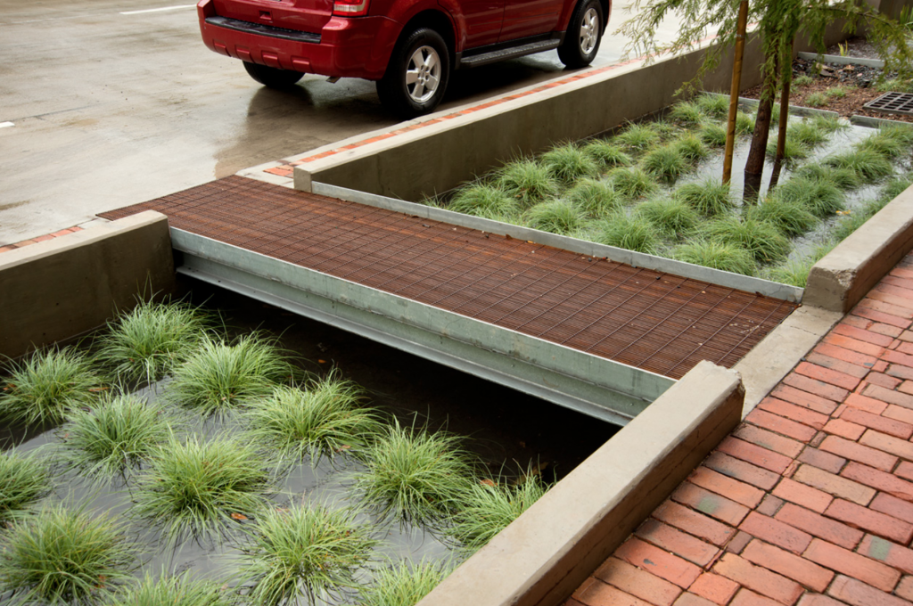
City: Houston Country / US State / US Territory: Texas Type of Solution: Streets and Parking Lots Climate Impact: Hurricanes and Storm Surge; Extreme Precipitation and Flooding; Air Quality Social Value Created: Diverse Transportation; Urban Beautification; Public Health and Safety; Water Security and Quality Cost: $9.6 million
Funding:
Bagby Street, a ten-block corridor in a dense, urban neighborhood underwent a redevelopment project. The project improved stormwater management to reduce flooding risks during hurricanes and severe storms. Green infrastructure systems were used to store and filter runoff, reducing flooding risk and improving water quality. The system has a smaller footprint than typical biofiltration systems, requiring only 1/20th of the space. 33% of stormwater runoff is captured by the system, removing 75% bacteria, 73% phosphorous, 93% oil and grease, 43% nitrogen, and 85% total suspended solids. Trees were also planted to aid with stormwater management, increasing the number of trees by 165%.
Additionally, the project improved traffic congestion and walkability, as well as the overall aesthetic appeal of the road, contributing to diverse transportation, public health and safety, and urban beautification. The smaller footprint design was essential for managing stormwater given the limited space available for green infrastructure. Private development also increased as a result of the project, totaling to $25 million in new development.
Sources: Atlas. (n.d.). Lower footprint biofiltration to increase efficiency in right of way stormwater capture. Retrieved from https://www.the-atlas.com/project?id=341#.
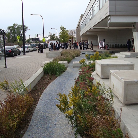
City: Chicago Country / US State / US Territory: Illinois Type of Solution: Streets and Parking Lots Climate Impact: Extreme Temperatures and Urban Heat Island Effect; Extreme Precipitation and Flooding Social Value Created: Public Health and Safety; Water Security and Quality; Diverse Transportation; Public Education; Public Education and Awareness; Community Wellbeing and Quality of Life
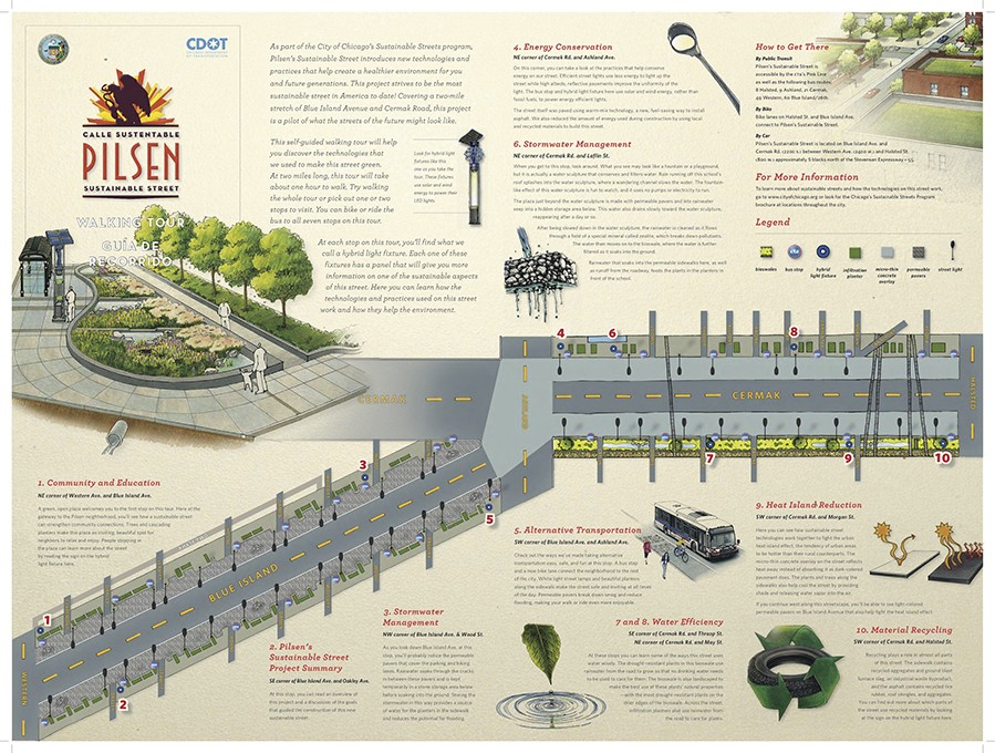
The Chicago Department of Transportation (CDOT) implemented the Pilsen Sustainable Streets project in 2012. The project uses permeable pavement and green infrastructure, such as bioswales and rain gardens, manage projected increases in heavy precipitation and flooding. Stormwater filtration helps to remove pollutants, improving water quality. The City of Chicago has a combined sewer system, making the ability to effectively manage stormwater essential to protecting public health.
Additionally, green infrastructure contributes to improved air quality and urban cooling, counteracting extreme temperatures and the urban heat island effect. The area of vegetative landscapes and tree canopy were increased by 131%, providing more shaded areas, lowering the temperature, and increasing stormwater filtration. Increased shade and lowered temperatures improves comfort of community members and improves public health.
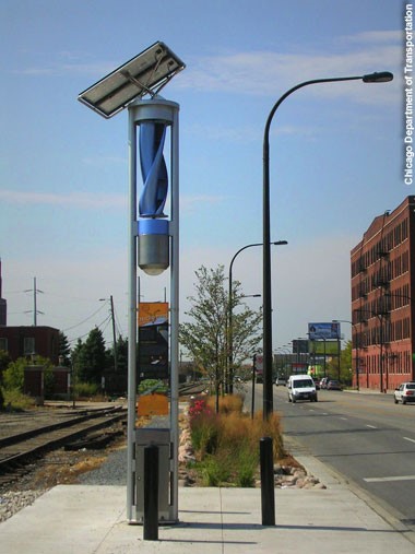
The project also resulted in creation of social value. A pedestrian refuge island was installed in Cermak Road and curb-corner extensions were created to improve pedestrian safety. Community outreach and education is another key feature of the project. Educational kiosks, a walking tour brochure, and a guidebook are available for community members to learn about the sustainable best practices employed by the project. These kiosks are powered by solar and wind energy.
City: Atlanta Country / US State / US Territory: Georgia Type of Solution: Vacant Commercial Properties and Lots Climate Impact: Extreme Temperatures and Urban Heat Island Effect; Air Quality; Extreme Precipitation and Flooding Social Value Created: Social Cohesion; Quality of Life; Public Health and Safety; Diverse Transportation; Historic Preservation; Public Spaces; Active Living and Playspaces
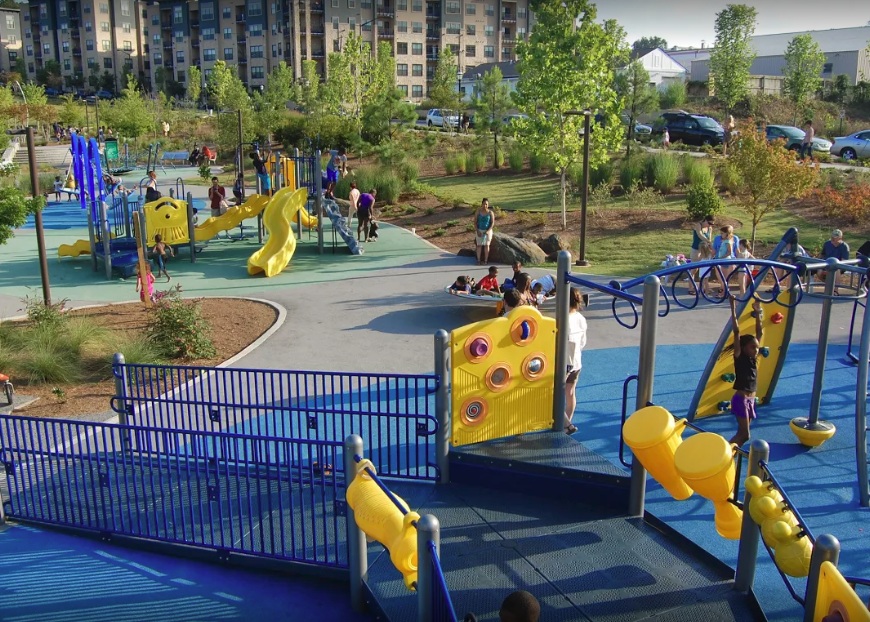
A former industrial and commercial property has been revitalized to become a 17-acre urban park, Historic Fourth Ward Park. The park is adjacent to the Atlanta BeltLine project, a rails to trails project that is restoring 22 miles of abandoned railway beds into recreational trails and a streetcar line. The $ project was completed in 2011, and the use of green infrastructure opposed to traditional gray infrastructure drainage system the city is estimated to have saved $15 million.
The park is located in an area that historically has experienced flooding and sewer overflows during storms. The green infrastructure system, consisting of bioretention, underground cisterns, and pervious surfaces, will help to improve stormwater management, with the capacity to capture runoff for a 100-year storm. Preventing sewer overflows helps to counteract the spread of waterborne diseases, contributing to public health.
One of the park’s features is a two-acre stormwater detention pond, Clear Creek Basin, which has already helped to reduce flooding in the surrounding neighborhoods. The Basin not only reduces flooding, but it also acts as a water reserve providing 425 gallons per minute even during a drought. The Basin was designed to use plantings and landscaping strategies used in wetlands.
Additionally, the greenspace improves air quality and contributes to urban cooling, mitigating extreme temperatures and the urban heat island effect. Trees and play structures increase shade, improving the comfort of community members and their overall quality of life.
In addition to improved stormwater management, a previously underutilized space is now creating social value for the community. The park provides community gathering space, contributing to social cohesion. In the park there is a playground and splash pad for children to play, which helps to keep children physically active, improving children’s health. The park also provides recreational paths for biking and walking, contributing to diversity of transportation.
Sources:
The Environmental Protection Agency. (2017). Green infrastructure in parks: a guide to collaboration, funding, and community engagement. Retrieved from http://www.adaptationclearinghouse.org/resources/green-infrastructure-in-parks-a-guide-to-collaboration-funding-and-community-engagement.html
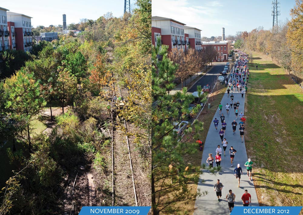
City: Atlanta Country / US State / US Territory: Georgia Type of Solution: Railways Climate Impact: Extreme Temperatures and Urban Heat Island Effect; Air Quality; Extreme Precipitation and Flooding Social Value Created: Diverse Transportation; Connectivity; Water Security and Quality; Active Living and Playspaces
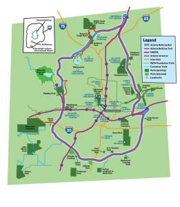
Fig: Map of the Atlanta BeltLine (Retrieved from https://beltline.org/about/the-atlanta-beltline-project/atlanta-beltline-overview/)The Atlanta BeltLine project is a rails to trails project that is converting 22 miles of abandoned railway beds into recreational trails for biking and pedestrians, as well as a streetcar line. The project will restore 700 acres of greenspace and create an additional 1,300 acres of greenspace. The $4.8 billion project begun in 2006 and is expected to be completed in 2030.
Greenspace improves air quality and contributes to urban cooling, counteracting extreme temperatures and the urban heat island effect. Additionally, the green infrastructure slows and captures stormwater during heavy rain events, presenting flooding.
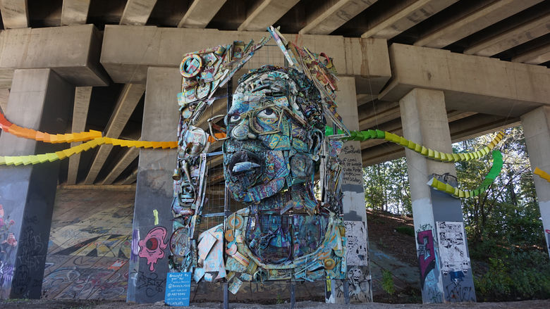
The BeltLine project also creates social value for the community. The BeltLine project increases diversity of transportation and improves connectivity between 45 neighborhoods of varying socioeconomic statuses and ethnicities. The greenspace will also help to filter water, improving water quality. Another unique feature of the BeltLine project is an outdoor public art-exhibit, displaying the work of more than 70 artists over the course of 9 miles of the BeltLine, contributing to the city’s arts and culture.